

Coldest Air So Far This Season Arrives Saturday
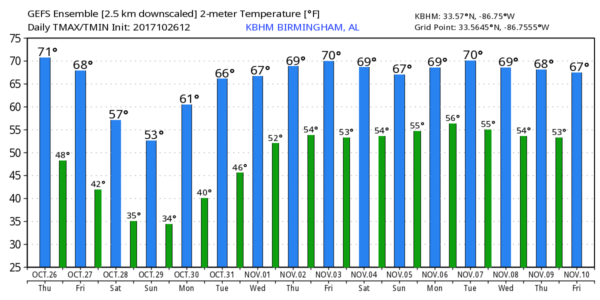
FINE FALL DAY: As advertised, temperatures have responded nicely to a strong October sun today with readings in the low 70s for most places at mid-afternoon. Tonight will be clear and not as cold as recent nights; lows will be in the upper 40s and low 50s early tomorrow.
RAIN RETURNS: Clouds increase tomorrow ahead of a cold front; there is only a small risk of an afternoon shower over the western half of the state. A few scattered showers are possible tomorrow evening between 6 and 9 p.m… mainly over the western half of Alabama, but the most widespread rain will come late tomorrow night into Saturday morning. The window for the most widespread rain comes from 10:00 p.m. tomorrow through 12:00 noon Saturday. Rain will linger over East Alabama Saturday afternoon. Rain amounts of 1/2 to 1 inch are likely.
A few strong storms are possible over Southwest Alabama tomorrow night, where SPC maintains a “marginal risk” of severe storms…
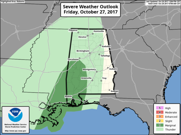
Note on the latest update Tuscaloosa and Birmingham have been removed from the marginal risk.
WINTER-LIKE DAY SATURDAY: In addition to the rain, Saturday will be a cold, blustery day with temperatures settling into the 48-51 degree range, and holding there through the afternoon with wind chill index values closer to 40. The average high for October 28 (for Birmingham) is 72. Look for gradual clearing Saturday night, and by early Sunday we drop down into the mid 30s. Frost is not especially likely Sunday morning as the wind will stay up through the night.
Sunday will be a mostly sunny, cool day with a high in the upper 50s.
FOOTBALL WEATHER: For the high school games across North/Central Alabama Friday night, we will need to mention the risk of scattered showers over the western half of the state. Otherwise, stadiums east of I-65 should be dry with the bulk of the rain holding off until the late night hours. The sky will be cloudy with temperatures falling from the upper 60s at kickoff to near 60 by the final whistle.
The annual Magic City Classic (Alabama State vs Alabama A&M) kicks off Saturday at 2:30 at Legion Field… it will be cloudy, breezy, and cold with temperatures hovering in the upper 40s during the game. Most of the rain should end by kickoff, but some drizzle could linger at times.
UAB plays Southern Mississippi at Hattiesburg Saturday (6:00p CT kickoff)… the weather will be breezy and cold with temperatures falling from 55 at kickoff, into the upper 40s by the fourth quarter. Rain over South Mississippi should end well before kickoff.
Jacksonville State will host Southeast Missouri State Saturday (3:00p CT kickoff)… it looks like most of the rain will be over by kickoff, otherwise cloudy, breezy, and cold with some drizzle and temperatures in the upper 40s and wind chill index values close to 40 degrees.
FROST/FREEZE THREAT MONDAY MORNING: The wind will be near calm early Monday, and we project lows in the 28-34 degree range for most communities along with widespread frost. For some, it will bring the first freeze of the season.
NEXT WEEK: Look for a slow warming trend beginning Monday afternoon, and by mid-week highs return to the low 70s. A few showers are possible Wednesday night or Thursday, but nothing heavy or widespread. See the Weather Xtreme video for maps, graphics, and more details.
TROPICS: A disturbance near the coast of Central America still has a medium chance of becoming a tropical depression over the next few days as it moves northeast; it will merge with a cold front and bring the threat of heavy rain to parts of the upper Atlantic coast of the U.S. by Sunday/Monday. The rest of the Atlantic basin is quiet.
BEACH FORECAST: Click here to see the AlabamaWx Beach Forecast Center page. The Beach Forecast is partially underwritten by the support of Brett/Robinson Vacation Rentals in Gulf Shores and Orange Beach. Click here to see Brett/Robinson’s Hot Deals now!
WEATHER BRAINS: Don’t forget you can listen to our weekly 90 minute netcast anytime on the web, or on iTunes. This is the show all about weather featuring many familiar voices, including our meteorologists here at ABC 33/40.
CONNECT: You can find me on all of the major social networks…
Facebook
Twitter
Google Plus
Instagram
Pinterest
Snapchat: spannwx
I enjoyed seeing the kids in the Sumter County Head Start program this morning in Livingston… be looking for them on the Pepsi KIDCAM today at 5:00 on ABC 33/40 News! The next Weather Xtreme video will be posted here by 7:00 a.m. tomorrow…
Category: Alabama's Weather, ALL POSTS, Weather Xtreme Videos
About the Author (Author Profile)
James Spann is one of the most recognized and trusted television meteorologists in the industry. He holds the AMS CCM designation and television seals from the AMS and NWA. He is a past winner of the Broadcast Meteorologist of the Year from both professional organizations.Subscribe
If you enjoyed this article, subscribe to receive more just like it.


