

Scattered Showers; Warm Weekend
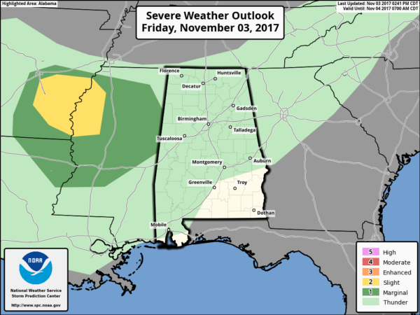
RADAR CHECK: Showers are widely scattered across Alabama this afternoon, otherwise we have a layer of broken clouds with temperatures mostly in the 70s. There is a risk of stronger storms to the west over North Mississippi in coming hours; some of those could drift into Alabama late tonight, but they should be weakening and no severe weather is expected in our state.
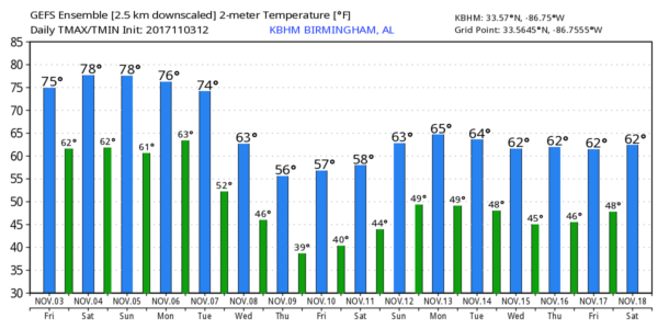
THE WEEKEND: Tomorrow will be a day with more clouds than sun, and a few widely scattered showers are possible. But, most of the day should be dry, and the high will be in the 77-80 degree range. Sunday looks warm and dry with a high close to 80 with a mix of sun and clouds.
FOOTBALL WEATHER: For high school games across North/Central Alabama tonight, the sky will be mostly cloudy with potential for a few widely scattered rain showers. Temperatures will fall from near 72 degrees at kickoff into the mid to upper 60s by the final whistle.
Alabama will host LSU tomorrow night (7:00p CT kickoff) at Bryant Denny Stadium in Tuscaloosa… the sky will be mostly cloudy with just the chance of a brief shower during the game. About 75 degrees at kickoff, upper 60s by the fourth quarter.
Auburn is on the road; they travel to College Station, TX to take on Texas A&M tomorrow (11:00a CT kickoff)… the weather will be warm and dry. The sky will be partly to mostly cloudy, temperatures will rise from near 80 at kickoff, into the mid 80s by the final whistle.
UAB will host the Rice Owls tomorrow at Legion Field (2:00p CT kickoff)… the sky will be occasionally cloudy, and a brief passing shower is possible during the game. It will be warm day; temperatures close to 80 at kickoff, falling back into the 70s by the fourth quarter.
NEXT WEEK: Monday will be a warm, dry day with potential for high in the low 80s. Then, a cold front will bring a chance of showers Tuesday afternoon and Tuesday night. Much cooler air rolls into the state Wednesday with some risk of showers, mainly during the morning hours. The high Wednesday will drop to near 60 degrees. Some light rain is possible Thursday as a wave forms on the stalled front over South Alabama; the latest GFS suggests we won’t get out of the 50s Thursday afternoon. And, Friday looks cool and dry with a high in the low 60s. See the Weather Xtreme video for maps, graphics, and more details.
TROPICS: A disturbance over the Central Atlantic will move north in coming days with only a low chance of development. The rest of the Atlantic basin is quiet.
BEACH FORECAST: Click here to see the AlabamaWx Beach Forecast Center page. The Beach Forecast is partially underwritten by the support of Brett/Robinson Vacation Rentals in Gulf Shores and Orange Beach. Click here to see Brett/Robinson’s Hot Deals now!
WEATHER BRAINS: Don’t forget you can listen to our weekly 90 minute netcast anytime on the web, or on iTunes. This is the show all about weather featuring many familiar voices, including our meteorologists here at ABC 33/40.
CONNECT: You can find me on all of the major social networks…
Facebook
Twitter
Google Plus
Instagram
Pinterest
Snapchat: spannwx
Look for my next Weather Xtreme video here Monday morning by 7:00 a.m… Brian Peters will have the video updates tomorrow and Sunday. Enjoy the weekend!
Category: Alabama's Weather, ALL POSTS, Weather Xtreme Videos
About the Author (Author Profile)
James Spann is one of the most recognized and trusted television meteorologists in the industry. He holds the AMS CCM designation and television seals from the AMS and NWA. He is a past winner of the Broadcast Meteorologist of the Year from both professional organizations.Subscribe
If you enjoyed this article, subscribe to receive more just like it.


