

Wet/Stormy Tonight/Tomorrow; Cold Christmas Day
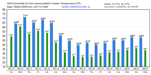
FOGGY START: All 67 Alabama counties are under a Dense Fog Advisory early this morning; visibility is very restricted… in come cases under 1/4 of a mile. After the fog dissipates, today will be mostly cloudy with some risk of showers this afternoon… and temperatures will rise into the mid 60s.
WET/STORMY TONIGHT AND TOMORROW: An upper low lifting out of the Southwest U.S. will bring rain and thunderstorms to Alabama late tonight and tomorrow. We will have potential for heavy rain at times, and also strong storms. SPC has North/Central Alabama under a “marginal risk” tomorrow as instability values will rise.
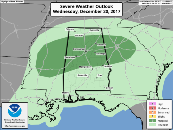
The main window for strong to severe storms will come from 6:00 a.m. until 3:00 p.m. tomorrow. The main threat with heavier storms will come from strong, gusty winds, although there is a low end threat of a couple of small, isolated tornadoes with rising SRH (storm relative helicity). Rain amounts of 1-2″ are likely across the central counties of the state, with amounts of 2-3″ for the Tennessee Valley of North Alabama.
THURSDAY/FRIDAY: The wave will be east of Alabama Thursday, and the day looks dry and mild. We will forecast a mix of sun and clouds with a high near 70 degrees, almost 15 degrees above average for mid to late December. Clouds thicken Thursday night, and rain should move back into the state Friday ahead of an Arctic front. Some thunder will be possible Friday afternoon, but severe storms, for now, are not expected.
THE WEEKEND: Saturday looks cool and wet. Rain will fall much of the day with temperatures falling through the 50s; some North Alabama communities could wind up in the 40s by afternoon. Then, by Sunday, the highest chance of rain shifts down into the southern part of the state.
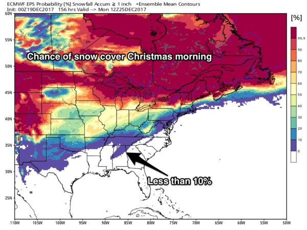
CHRISTMAS DAY: We are getting good model agreement now; both the American (GFS) and European (ECMWF) global models are showing dry and cold conditions for Alabama Christmas Day. The sky partly to mostly sunny with temperatures having a hard time getting out of the 30s. This, of course, could change, but odds of a “White Christmas” for Alabama look very low as usual.
REST OF NEXT WEEK: Cold air stays in place; we will need to keep an eye on the next system due in at the end of the week. For the moment, models suggest it will be warm enough for just rain across our state.
BEACH FORECAST: Click here to see the AlabamaWx Beach Forecast Center page. The Beach Forecast is partially underwritten by the support of Brett/Robinson Vacation Rentals in Gulf Shores and Orange Beach. Click here to see Brett/Robinson’s Hot Deals now!
WEATHER BRAINS: Don’t forget you can listen to our weekly 90 minute netcast anytime on the web, or on iTunes. This is the show all about weather featuring many familiar voices, including our meteorologists here at ABC 33/40.
CONNECT: You can find me on all of the major social networks…
Facebook
Twitter
Google Plus
Instagram
Pinterest
Snapchat: spannwx
I have a weather program this morning at Shades Mountain Elementary in Hoover… be looking for the next Weather Xtreme video here by 4:00 this afternoon. Enjoy the day!
Category: Alabama's Weather, ALL POSTS, Weather Xtreme Videos
About the Author (Author Profile)
James Spann is one of the most recognized and trusted television meteorologists in the industry. He holds the AMS CCM designation and television seals from the AMS and NWA. He is a past winner of the Broadcast Meteorologist of the Year from both professional organizations.Subscribe
If you enjoyed this article, subscribe to receive more just like it.


