

Cold, Colder, Frigid!
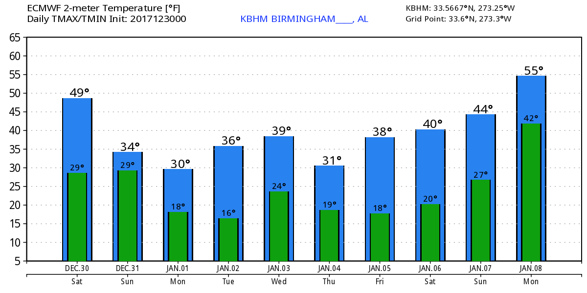
Much of the Southeast US is cloudy this morning as we prepare for an extended period of really cold weather. Birmingham hit 53 degrees for the high yesterday, and that is likely to be the warmest day we see for the next 8 to 10 days. Additional clouds today along with yet another shot of cold air arriving will hold the afternoon high to the upper 40s.
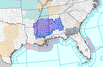
Precipitation is forecast to break out to the southwest of the Birmingham area during the early morning hours tomorrow morning. The precipitation is likely to be confined generally along and south of a line from Jackson, MS, to Tuscaloosa, AL. A narrow band of a light wintry mix – sleet, freezing rain, light rain – on the northern boundary of the rain area has prompted the issuance of a winter weather advisory for portions of Central Mississippi and West Central Alabama. Primary time frame for this wintry mix will be between 3 am and 6 pm Sunday. Some travel issues are likely in the area of the advisory mostly in the form of icing on bridges and other elevated roadways. It’s nice to see the GFS and the ECMWF in pretty close agreement on the pattern, closer than they have been over the last week. Drier and colder air should push into the area during the afternoon Sunday bringing an end to the precipitation as it moves southeastward.
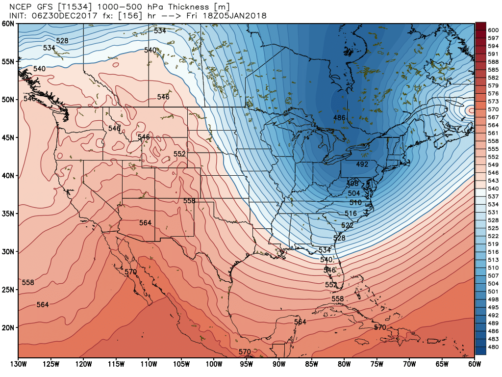
The pattern of a broad upper trough over the eastern two-thirds of the US will continue with passing short waves that will continually feed and reinforce the cold air. Morning low temperatures for Monday through Friday are likely to be in the teens which is the reasoning behind the issuance of a hard freeze watch from Sunday night through Wednesday morning. Afternoon highs are not expected to do much better with highs primarily in the middle and upper 30s – the warmer days could see highs in the lower 40s. All of this is very, very cold when you consider the average high for early January is about 54.
Because of the extended period of cold, people need to consider some cold weather preparation. This could include preparing any exposed water pipes and taking steps to make sure pets will have warm housing. The extended cold also means checking on elderly friends and relatives who are often impacted by the cold more than other age groups.
Toward the end of next weekend and into the first of next week, the GFS is showing signs of a little relief from the cold as an upper ridge moves from the Rockies on Saturday into the eastern US on Monday. That warming does not last long as another digging trough carves out the trough over the East again by the 10th of January. Yet another ridge brings relief around the 12th of January. That ridge lasts for a couple of days but another strong trough is forecast to move eastward from the Rockies by the 14th. Screaming message from voodoo country is the active nature to the overall weather pattern. It sure looks like it is going to be a roller coaster ride for the first portion of January.
Both Auburn and Alabama will be playing inside enclosed stadiums, so there is no worry about the weather during the games. But getting there and home may see some issues. For those headed to Atlanta for the Peach Bowl with Auburn facing the UCF Knights with an 11:45 am CST kickoff, it looks like travel will be just fine. New Year’s Eve will be cold with a high of only 41, and game day will be even colder with a high of only 34.
For the Sugar Bowl in New Orleans where Alabama and Clemson face-off at 7:45 pm CST, if your plans call for travel during the day Sunday, you’ll want to add some extra time to your trip to account for the impacts of slick spots on bridges and overpasses in West Central Alabama and Southeast Mississippi. There will be a chance for rain in New Orleans for New Year’s Eve with a high of 57. New Year’s Day should also see sunshine with a high around 39.
Beach Forecast: Click here to see the AlabamaWx Beach Forecast Center page. The Beach Forecast is partially underwritten by the support of Brett/Robinson Vacation Rentals in Gulf Shores and Orange Beach. Click here to see Brett/Robinson’s Hot Deals now!
WeatherBrains: Don’t forget you can listen to our weekly 90 minute netcast anytime on the web, or on iTunes. This is the show all about weather featuring many familiar voices, including our meteorologists here at ABC 33/40.
Special thanks to Bill Murray for filling in for me yesterday while I covered the morning weather duties on ABC 3340. I’ll be handling the weekend weather shifts, so you can catch the latest forecast at 6 and 10 pm today on ABC 3340. I expect to have the next Weather Xtreme Video posted here first thing Sunday morning. Have a great day and Godspeed.
-Brian-
Category: Alabama's Weather, ALL POSTS, Weather Xtreme Videos
About the Author (Author Profile)
Brian Peters is one of the television meteorologists at ABC3340 in Birmingham and a retired NWS Warning Coordination Meteorologist. He handles the weekend Weather Xtreme Videos and forecast discussion and is the Webmaster for the popular WeatherBrains podcast.Subscribe
If you enjoyed this article, subscribe to receive more just like it.


