

Warming Continues; Wet Monday
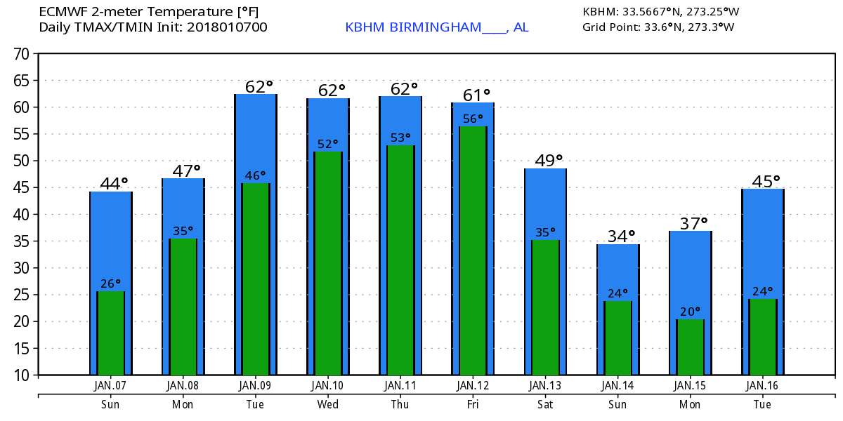
High cirrus clouds, somewhat thicker than we saw yesterday, were streaming into the Southeast US ahead of a developing low pressure in the Texas Panhandle. The day will be dry with sunshine more muted than yesterday and highs are expected to reach the upper 40s.
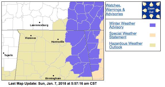
The upper storm system over the Texas Panhandle today will do a somewhat uncharacteristic dive to the Gulf Coast on Sunday as the surface low moves southeastward into Southeast Louisiana. This will produce rain over a good portion of the Southeast US Sunday night into Monday. There is a risk for some wintry precipitation over Northeast Alabama and Northwest Georgia from about 11 pm Sunday night through about 9 am Monday morning. This has prompted the issuance of winter weather advisories for counties along the Alabama/Gerogia border from Chattanooga to Oxford/Anniston area. The biggest threat appears to be a very light coating of ice on exposed surfaces which includes bridges and elevated roadways. If you are traveling to Atlanta for the championship game on Monday, you should allow a little extra time for traffic issues. Temperatures should warm above freezing during the mid morning hours.
Tuesday the upper low dives further southeastward into the eastern Gulf taking the surface low to the Bahamas. Ridging just to our west will help us warm up with highs Monday around 50 and Tuesday in the upper 50s.
Wednesday the next upper level storm system will be taking shape over New Mexico with a surface low forming in eastern Colorado. We should remain dry Wednesday with highs in the 60s – now won’t that feel good!!
Thursday the upper trough will approach the Mississippi River and our surface flow comes around to the south increasing moisture with the potential for some patchy rain or showers. The GFS MOS guidance prints out a high of 71 for Thursday, and while I would like to see it that warm, I think highs in the 60s is more likely.
Late Thursday into early Friday, a secondary surface low is forecast to form along the approaching front and bring us additional rain which is forecast to move out by late Friday afternoon paving the way for a dry weekend that will also be colder again as another trough sets up over the eastern US. This should drive temperatures lower again with lows below freezing and highs mainly in the 40s.
The initial pattern as we look forward into voodoo country stays cold through the 17th of January, but by the 18th the upper flow has gone zonal across the southern tier of the US. The zonal pattern morphs into a rather substantial ridge on the 20th of January. But the pattern remains active with a very strong upper trough coming into the Central US by the 22nd. And the upper air chart for the 22nd looks pretty mean with potential for severe weather along with winter weather for the northern US. Just what it looks like, because you know this whole patter could be completely changed in the next model run.
Football Weather: For fans headed to Atlanta for Monday’s national championship game, there is a window Monday morning when some freezing rain is possible across North Georgia with potential for a little bridge icing. This should be a temporary issue, and temperatures should be above freezing in Atlanta by late morning. Rain is likely through Monday night, so take some rain gear if you plan on walking to Mercedes Benz Stadium. The high in Atlanta Monday will be in the lower 40s.
Beach Forecast: Click here to see the AlabamaWx Beach Forecast Center page. The Beach Forecast is partially underwritten by the support of Brett/Robinson Vacation Rentals in Gulf Shores and Orange Beach. Click here to see Brett/Robinson’s Hot Deals now!
WeatherBrains: Don’t forget you can listen to our weekly 90 minute netcast anytime on the web, or on iTunes. This is the show all about weather featuring many familiar voices, including our meteorologists here at ABC 33/40.
Thanks so much for tuning into the Weather Xtreme Video. James Spann will be back with the next scheduled edition by 7 am or so on Monday. Have a great day and Godspeed.
-Brian-
Category: Alabama's Weather, ALL POSTS, Weather Xtreme Videos
About the Author (Author Profile)
Brian Peters is one of the television meteorologists at ABC3340 in Birmingham and a retired NWS Warning Coordination Meteorologist. He handles the weekend Weather Xtreme Videos and forecast discussion and is the Webmaster for the popular WeatherBrains podcast.Subscribe
If you enjoyed this article, subscribe to receive more just like it.


