

Winter Weather Advisory Far North Alabama
FEELS LIKE SPRING: Temperatures have soared into the low 70s in some spots across Alabama this afternoon, mainly where there have been breaks in the overcast. On radar some rain is falling over the western side of the state, but nothing too heavy or widespread. Showers will increase across Alabama tonight, ahead of a very sharp Arctic cold front now over western Arkansas. Some thunder is possible, but there is no risk of severe thunderstorms. Rain amounts overnight should be in the 1/2-3/4″ range for most places.
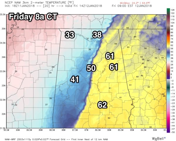
TEMPERATURES PLUNGE TOMORROW: The Arctic front will move through our state tomorrow morning. Those in Central and East Alabama will begin the day in the 60s, but temperatures will drop 20-30 degrees in about one hour after the front’s passage… be prepared! Rain will end from west to east during the day, and over far North Alabama, rain will change to a “wintry mix” of sleet, freezing rain, and snow before ending. NWS Huntsville continues a “winter weather advisory” for Franklin, Colbert, Lauderdale, Limestone, Madison, and Jackson counties tomorrow… where light accumulation is possible.
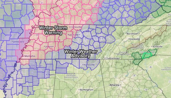
Advisories are also in effect to the north over Middle Tennessee, including Nashville, and much of West Tennessee is under a winter storm warning, where accumulations are expected to be higher (1-3″ of snow possible in the warning area)
*Look for icy travel over far North Alabama (the counties in the advisory area) and much of Tennessee tomorrow due to incoming Arctic air and the sleet/snow/freezing rain mix.
*A few flurries are possible south of the advisory over parts of North Alabama tomorrow, but no accumulation or travel impact. The big story for most of the state is the incoming frigid air.
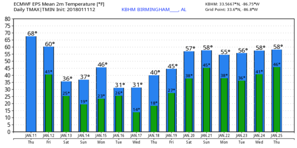
THE ALABAMA WEEKEND: Very cold, and dry. Morning clouds will give way to afternoon sunshine Saturday with a high in the upper 30s; a brisk north wind of 12-25 mph will make it feel colder. Then we drop down into the upper teens by daybreak Sunday with a clear sky and diminishing wind. The day Sunday will be sunny with a high between 37 and 40 degrees.
NEXT WEEK: Monday will be a sunny day with a high in the 40s, but a clipper brings down even colder air Tuesday. New model data hints much of North Alabama will be below freezing all day Tuesday, and by early Wednesday morning we will be in the 10-15 degree range across North/Central Alabama. The weather stays cold and dry for the rest of the week.
Next chance of showers will come around Sunday January 21, or Monday January 22. See the Weather Xtreme video for maps, graphics, and more details.
BEACH FORECAST: Click here to see the AlabamaWx Beach Forecast Center page. The Beach Forecast is partially underwritten by the support of Brett/Robinson Vacation Rentals in Gulf Shores and Orange Beach. Click here to see Brett/Robinson’s Hot Deals now!
WEATHER BRAINS: Don’t forget you can listen to our weekly 90 minute netcast anytime on the web, or on iTunes. This is the show all about weather featuring many familiar voices, including our meteorologists here at ABC 33/40.
CONNECT: You can find me on all of the major social networks…
Facebook
Twitter
Google Plus
Instagram
Pinterest
Snapchat: spannwx
Look for the next Weather Xtreme video here by 7:00 a.m. tomorrow…
Category: Alabama's Weather, ALL POSTS, Weather Xtreme Videos
About the Author (Author Profile)
James Spann is one of the most recognized and trusted television meteorologists in the industry. He holds the AMS CCM designation and television seals from the AMS and NWA. He is a past winner of the Broadcast Meteorologist of the Year from both professional organizations.Subscribe
If you enjoyed this article, subscribe to receive more just like it.


