

Frigid Weekend; Snow Possible Next Tuesday
COLD/LIGHT SNOW: As advertised, cold, Arctic air has returned to Alabama, and radar shows some light snow continuing over the northern half of the state. We have reports of flurries as far south as Livingston and Demopolis. A winter weather advisory continues for the far northern part of Alabama, up in the Tennessee Valley, where icy travel is possible tonight. The counties in the advisory are Franklin, Colbert, Lauderdale, Lawrence, Limestone, Madison, and Jackson…

Flurries and a little sleet are possible down into Central Alabama over the next few hours, but there will be no impact. Strong northwest winds have dried road surfaces. Precipitation will end tonight from west to east.
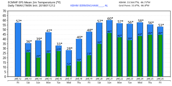
FRIGID WEEKEND: The sky becomes partly sunny tomorrow with a high in the 36-39 degree range. Sunday will feature a morning low in the upper teens, followed by a high around around 40 with a good supply of sunshine.
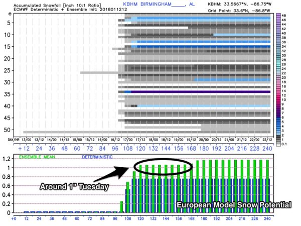
WINTER MISCHIEF NEXT WEEK? Monday will be dry with a high in the upper 40s, but a clipper type system will arrive Tuesday with a fresh supply of very cold air. Global models are suggesting some Gulf moisture could become involved in this, with potential for some light accumulating snow over a decent part of Alabama. The GFS even hints some snow could fall as far south as Mobile, Fairhope, and Gulf Shores by Tuesday night or early Wednesday morning.
The ensemble mean from the reliable European global model is showing about one inch of snow for North/Central Alabama, with potential for heavier amounts in a few spots to the south, where moisture will be deeper. Needless to say, it is way too early for a specific forecast on snow amounts and impact, but just be aware of the potential.
Wednesday and Thursday will feature very cold mornings with low between 10 and 15 degrees; a good chance we stay below freezing all day Wednesday. Then, a warming trend begins later in the week. See the Weather Xtreme video for maps, graphics, and more details.
BEACH FORECAST: Click here to see the AlabamaWx Beach Forecast Center page. The Beach Forecast is partially underwritten by the support of Brett/Robinson Vacation Rentals in Gulf Shores and Orange Beach. Click here to see Brett/Robinson’s Hot Deals now!
WEATHER BRAINS: Don’t forget you can listen to our weekly 90 minute netcast anytime on the web, or on iTunes. This is the show all about weather featuring many familiar voices, including our meteorologists here at ABC 33/40.
CONNECT: You can find me on all of the major social networks…
Facebook
Twitter
Google Plus
Instagram
Pinterest
Snapchat: spannwx
I had a great time today visiting with the 3rd graders at Hemphill Elementary in Birmingham… be looking for them on the Pepsi KIDCAM today at 5:00 on ABC 33/40 News! My next Weather Xtreme video will be posted here Monday morning by 7:00 a.m…. Brian Peters will have the video updates tomorrow and Sunday. Enjoy the weekend!
Category: Alabama's Weather, ALL POSTS, Weather Xtreme Videos
About the Author (Author Profile)
James Spann is one of the most recognized and trusted television meteorologists in the industry. He holds the AMS CCM designation and television seals from the AMS and NWA. He is a past winner of the Broadcast Meteorologist of the Year from both professional organizations.Subscribe
If you enjoyed this article, subscribe to receive more just like it.


