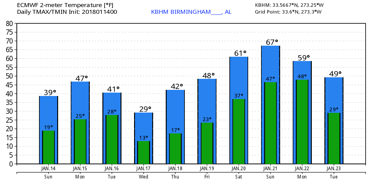
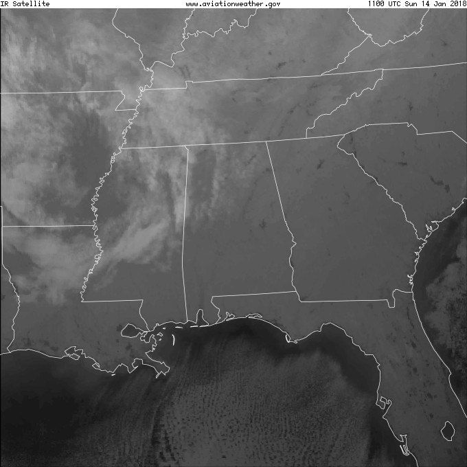
It’s cold once again this morning as temperatures in the teens were reported across nearly all of the northern half of Alabama. The regional satellite view for the Southeast US showed some high and middle clouds surging eastward into Alabama this morning while South Alabama remained in clear weather. Looks like we’ll see some sunshine though it will be filtered through those middle and high clouds today as highs struggle to reach the 40-degree mark.
Monday we warm up a little with highs near 50 as the upper air pattern goes zonal across the Southeast US. But we have our eye on the next surge of cold air as a strong upper trough situated from Wisconsin across the Dakotas gets ready to dive into the eastern US. That trough plunges into the Southeast US on Tuesday and edges by us by midday on Wednesday. Amazingly, we see some pretty good consistency in the GFS and European models. Both are forecasting precipitation in the form of snow chances behind the front. The European is somewhat more aggressive with the snow, but neither system is suggesting anything more a dusting to perhaps an inch. The surface pattern with a low well northeast of us over the eastern Great Lakes with a front trailing into the Southeast US together with a strong trough slightly behind the surface front is the kind of pattern that can bring fairly good snow chances but rarely brings more than light amounts of snow. Tuesday also appears to be another one of those days in which the temperature will be trending in the wrong direction. The morning low will be around 30 degrees. But after a brief rise in temperatures during the morning hours from sunrise to 10 or 11 am, temperatures will be falling with readings potentially reaching the middle and upper 20s by 6 pm.
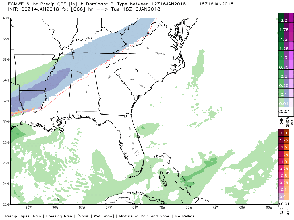
While the forecast for snow is pretty confident with the latest data, the actions on school closings is anybody’s guess. As I noted in the paragraph above, these kinds of weather systems do not typically result in any serious snow amounts. With my forecast calling for amounts to be generally less than an inch, I am expecting to see primarily minor travel issues. The snow should be tapering off in the evening as we head toward the midnight hour.
The trough passes Wednesday morning, so we’re going to see yet another shot of deep freeze kind of weather with morning lows on Wednesday and Thursday in the teens – most likely in the range from 13 to 17 degrees. Because the surface high will be settling into the Southeast with the center located near Muscle Shoals come Thursday morning, it’s possible we could see some of those normally colder locations hit single digit lows of 7 to 9 degrees.
Another short wave moves through the flow come Thursday, so that by Friday we come under the eastern edge of a weak upper ridge. The highs Thursday and Friday will climb into the 40s, perhaps reaching 50 degrees by Friday afternoon.
Another strong upper trough digs into the Four Corners area on Saturday helping to pump up the ridge over the eastern portion of the US so high temperatures by Saturday should soar into the lower 60s. Along with a return to southerly flow across the Southeast US bringing moisture back into the picture, we have a good chance for rain with the approach of a surface front on Sunday.
Looking out into voodoo country, the upper trough passes on Monday with a brief cool down but another extreme. From the 24th of January through the end of the period, the GFS maintains an upper ridge over the eastern third of the country while the traveling weather systems are pushed further north across the Great Lakes. This pattern if it verifies should keep us in the Southeast fairly warm from the 24th through the 29th.
Beach Forecast: Click here to see the AlabamaWx Beach Forecast Center page. The Beach Forecast is partially underwritten by the support of Brett/Robinson Vacation Rentals in Gulf Shores and Orange Beach. Click here to see Brett/Robinson’s Hot Deals now!
WeatherBrains: Don’t forget you can listen to our weekly 90 minute netcast anytime on the web, or on iTunes. This is the show all about weather featuring many familiar voices, including our meteorologists here at ABC 33/40.
Special thanks to Bill Murray for handling the duties for the Weather Xtreme Video yesterday so my wife and I could enjoy an overnight trip to Montgomery where we attended the Jeanne Robertson show at the Montgomery Performing Arts Theater. Jeanne is a professional speaker who always tries to find humor in what goes on around her, even when the breaks her femur! James Spann will have the next Weather Xtreme Video here on Monday morning. Depending on how the snow situation develops, you may be able to catch me Tuesday chasing snowflakes around Central Alabama. Have a great day and Godspeed.
-Brian-