

Occasional Rain Over The Weekend
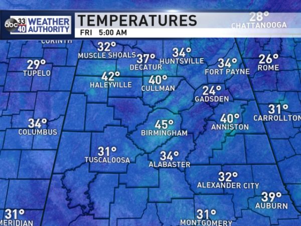
ONE MORE DRY DAY: Temperatures are all over the board this morning; a reminder that “one number” sometimes doesn’t work well in a forecast on a clear, calm morning. Birmingham reports 45 degrees just before daybreak, but some places are over 20 degrees colder. This is due to UHI (Urban Heat Island) effect, and local variations of wind and cloud cover.
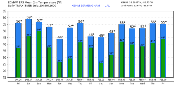
We expect a partly to mostly sunny sky today with a high at or just over 60 this afternoon. Enjoy it; it will be the last day with a 60 degree high for a while. Clouds thicken tonight.
THE WEEKEND: A wave of low pressure will form in the northern Gulf of Mexico, and we will have some rain at times tomorrow as moisture levels continue to rise. But, it won’t rain all day… the most widespread rain should come tomorrow night into Sunday morning as the low passes to the south. Then, rain should end from west to east Sunday afternoon. Rain amounts of around 1/2″ are expected for the northern half of the state, with heavier totals down south near the coast. No risk of severe weather, and probably no thunder in a stable airmass. Highs tomorrow and Sunday will be in the 57-60 degree range.
NEXT WEEK: The first half of the week will be dry and colder. Coldest day will be Tuesday with a high only in the mid 40s; early morning temperatures will drop down into the low and mid 20s early Tuesday and Wednesday morning. Some of the normally colder spots could reach the upper teens.
Clouds return Thursday ahead of a cold front, and some rain is likely by Thursday afternoon and Thursday night. Rain should end from west to east Friday of next week as colder air rolls into the state. Can’t totally rule out a few flurries Friday morning as the cold air enters the state, but global model data for now shows no sign of any impact if by chance that happens.
The following weekend (February 3/4) looks cold and dry. See the Weather Xtreme video for maps, graphics, and more details.
BEACH FORECAST: Click here to see the AlabamaWx Beach Forecast Center page. The Beach Forecast is partially underwritten by the support of Brett/Robinson Vacation Rentals in Gulf Shores and Orange Beach. Click here to see Brett/Robinson’s Hot Deals now!
WEATHER BRAINS: Don’t forget you can listen to our weekly 90 minute netcast anytime on the web, or on iTunes. This is the show all about weather featuring many familiar voices, including our meteorologists here at ABC 33/40.
CONNECT: You can find me on all of the major social networks…
Facebook
Twitter
Google Plus
Instagram
Pinterest
Snapchat: spannwx
I have a weather program this morning at Vincent Elementary in Shelby County… look for the next Weather Xtreme video here by 4:00 this afternoon. Enjoy the day!
Category: Alabama's Weather, ALL POSTS, Weather Xtreme Videos
About the Author (Author Profile)
James Spann is one of the most recognized and trusted television meteorologists in the industry. He holds the AMS CCM designation and television seals from the AMS and NWA. He is a past winner of the Broadcast Meteorologist of the Year from both professional organizations.Subscribe
If you enjoyed this article, subscribe to receive more just like it.


