

Dry But Colder Today; Rain Returns Thursday
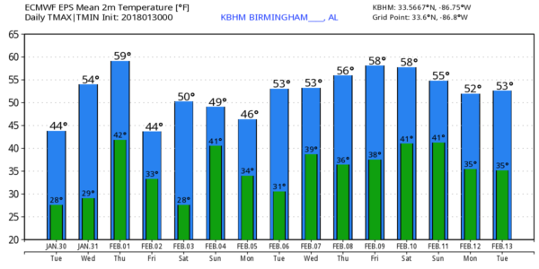
COLDER: Many communities across North/Central Alabama hit the 60 degree mark yesterday, but today will be about 15 degrees colder with highs in the 44-47 degree range despite sunshine in full supply. Tonight will feature another freeze; we drop down into the mid 20s early tomorrow morning. But, expect a nice warm-up tomorrow afternoon as temperatures rise into the mid to upper 50s. The air remains dry tomorrow and the sky will stay mostly sunny.
RAIN RETURNS: Clouds surge back into the state Thursday ahead of a cold front, and we expect periods of light rain Thursday afternoon and Thursday night. Rain amounts should be under 1/2″ and there is no chance of severe storms. Probably no thunder. We reach the upper 50s Thursday afternoon ahead of the front.
FRIDAY/SATURDAY: Friday will feature a clearing sky, and again we will deal with a glancing blow of an Arctic airmass; the high Friday will be in the mid 40s with a cool north breeze. With a clear sky and light wind, Friday night will be cold… we project a low in the mid 20s early Saturday. But, we warm back into the low 50s Saturday afternoon with a partly sunny sky. No doubt Saturday is your day if you need to get something done outdoors this weekend.
MORE RAIN SUNDAY: Clouds return to the state Saturday night, and Sunday will be a wet day with occasional rain. Once again, no instability so no risk of severe storms, and probably no thunder. Rain amounts Sunday should be 1/2 inch or less, with temperatures struggling to reach the low 50s. Rain will end Sunday night, and a snowflake isn’t totally out of the question over far North Alabama as colder air moves in, but temperatures will be above freezing and there should not be any impact.
NEXT WEEK: Monday and Tuesday will be cool and dry with highs in the 45-50 degree range, then a wave brings a chance of rain back to the state Wednesday. It is important to note there is no evidence of any significant snow or ice issues, or any long lasting bitterly cold Arctic air outbreaks for Alabama using ensemble model output for the next 7 to 10 days… see the Weather Xtreme video for maps, graphics, and more details.
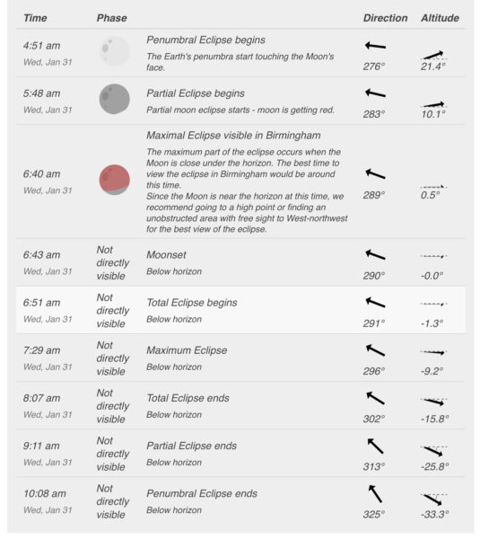
SUPER BLUE MOON PARTIAL ECLIPSE: We will have a partial “Super Blue Moon” eclipse early tomorrow morning… The sky should be clear in Alabama. For Birmingham, the partial eclipse begins at 5:48; eclipse max comes at 6:40, right before moonset, which comes at 6:43. Meaning, the moon will be very low on the horizon; you need to be on a ridge, or higher terrain, to see the partial eclipse. It is a “blue moon” because it is the second full moon in a calendar month, and a “super moon” because the moon is at perigee, or a point in its orbit at which it is closest to Earth. This makes the moon appear up to 14 percent larger and 30 percent brighter than usual.
BEACH FORECAST: Click here to see the AlabamaWx Beach Forecast Center page. The Beach Forecast is partially underwritten by the support of Brett/Robinson Vacation Rentals in Gulf Shores and Orange Beach. Click here to see Brett/Robinson’s Hot Deals now!
WEATHER BRAINS: Don’t forget you can listen to our weekly 90 minute netcast anytime on the web, or on iTunes. This is the show all about weather featuring many familiar voices, including our meteorologists here at ABC 33/40.
CONNECT: You can find me on all of the major social networks…
Facebook
Twitter
Google Plus
Instagram
Pinterest
Snapchat: spannwx
I have weather programs today at White Plains Elementary and Weaver Elementary in Calhoun County… look for the next Weather Xtreme video here by 4:00 this afternoon. Enjoy the day!
Category: Alabama's Weather, ALL POSTS, Weather Xtreme Videos
About the Author (Author Profile)
James Spann is one of the most recognized and trusted television meteorologists in the industry. He holds the AMS CCM designation and television seals from the AMS and NWA. He is a past winner of the Broadcast Meteorologist of the Year from both professional organizations.Subscribe
If you enjoyed this article, subscribe to receive more just like it.


