

Mild Temperatures; A Few Showers
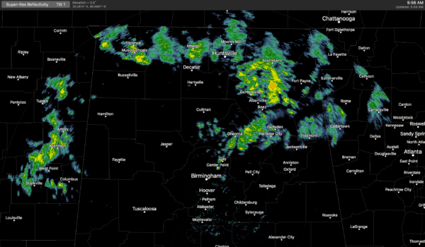
RADAR CHECK: Showers are over the northern third of Alabama this morning… moving eastward. Better coverage of rain is up over the Tennessee Valley at daybreak.
Today will be mostly cloudy and mild, and we will continue to mention a chance of showers, with the best coverage north of I-20. The high today should be in the mid to upper 60s. Not much change tomorrow; another mostly cloudy and mild day with a shower possible, but not especially likely, as an upper ridge over the Gulf of Mexico noses in here from the south. A good chance we reach the low 70s tomorrow afternoon as the mild February pattern continues.
FRIDAY AND THE WEEKEND: A surface front will approach from the north, and will bring an increase in coverage of showers late Friday afternoon, Friday night, and into Saturday. Once again, the highest coverage of showers will be over the northern third of the state, but we will see some rain at times over the central counties of the state. The front will become stationary somewhere over North Alabama Saturday; where the front stops will determine temperatures…. north of the front highs Saturday will be in the 50s, to the south we will see mid to upper 60s.
This won’t be like the big deluge we dealt with last Saturday; just be ready for a few showers. Sunday looks drier, although we will still need to mention at least a chance of widely scattered showers over North Alabama. Sunday’s high will be in the 60s.
The upper ridge over the Gulf of Mexico will keep South Alabama mostly dry over the weekend with only isolated showers there.
NEXT WEEK AND BEYOND: The overall pattern just won’t change much. An upper trough over the western U.S., with ridging over the Gulf of Mexico. Next week will be mild with some risk of showers on a daily basis. Higher coverage of showers will remain over the northern third of the state, with generally dry conditions over South Alabama thanks to the ridge. Any showers over the southern counties should be pretty widely spaced. Highs will be in the 60s and 70s.
Global model guidance suggests the mild temperatures will hang on for the rest of February.

But, understand we always have cold snaps in Alabama in March and April… winter is far from over. The average date of the last freeze in Birmingham is April 1, based on data from 1981-2010. And yes, we have experienced big snows as late as the first week in April.
BEACH FORECAST: Click here to see the AlabamaWx Beach Forecast Center page.
WEATHER BRAINS: Don’t forget you can listen to our weekly 90 minute netcast anytime on the web, or on iTunes. This is the show all about weather featuring many familiar voices, including our meteorologists here at ABC 33/40.
CONNECT: You can find me on all of the major social networks…
Facebook
Twitter
Google Plus
Instagram
Pinterest
Snapchat: spannwx
I have a weather program this morning at Gardendale Elementary… be looking for the next Weather Xtreme video here by 4:00 this afternoon. Enjoy the day!
Category: Alabama's Weather, ALL POSTS, Weather Xtreme Videos
About the Author (Author Profile)
James Spann is one of the most recognized and trusted television meteorologists in the industry. He holds the AMS CCM designation and television seals from the AMS and NWA. He is a past winner of the Broadcast Meteorologist of the Year from both professional organizations.Subscribe
If you enjoyed this article, subscribe to receive more just like it.


