


WEATHER CONDITIONS AT THE MIDDAY HOUR
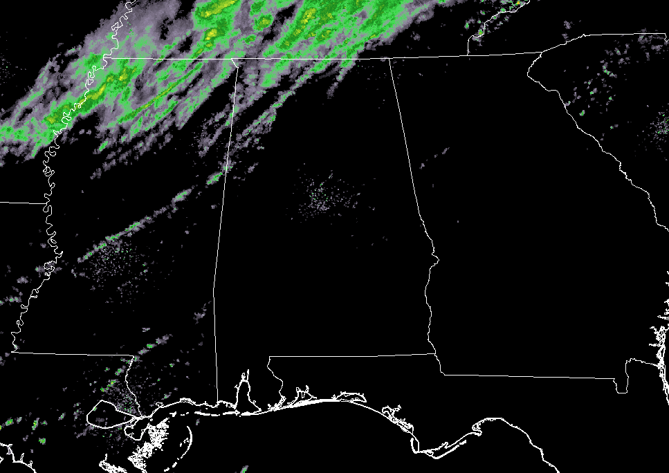
For most of Central Alabama, we have more clouds than sun, but temperatures have really warmed nicely with the exception of the extreme northern parts of the area. We are currently seeing temperatures ranging from the mid-50s in the northwestern parts, mid-60s to the lower 70s in the central parts, and the mid to upper 70s in the south. Radar is showing showers moving into the northwestern parts of the area, currently affecting parts of Lamar, Fayette, Marion, and Winston counties. These are moving eastward and should be affecting Walker and Cullman counties within the hour.
WEATHER FOR THE REST OF YOUR SATURDAY
Skies will continue to be mainly cloudy throughout the day with a chance of showers over the northern half of the area (north of I-20) We’ll have a big range of temperatures throughout the area, with highs in the mid-50s in the extreme northwest to the upper 70s to near 80 degrees in the extreme southeast. Birmingham’s high will be in the upper 60s. Those shower chances will continue throughout the late night and overnight hours, with the higher chances moving farther southward to be over and around I-59. Lows will range from the lower 40s to the lower 60s.
WE’LL CONTINUE TO HAVE SOME SHOWERS ON SUNDAY WITH TEMPERATURES GETTING CLOSER
The good news is that the cooler temperatures will be pushed back to the north out of the area, unfortunately rain chances continue throughout the daytime hours. Rain chances will lessen throughout the day, with only widely scattered showers expected. Once again, the better chances for rain will be in the northern 2/3rds of Central Alabama (north of I-85). Highs will be in the lower 60s to the lower 70s.
WARMER TEMPERATURES MOVE IN DURING NEXT WEEK, AND SO DO THE RAIN CHANCES
Monday and Tuesday will be the driest of the five days of the work week, as the upper ridge over the gulf strengthens and moves northward. Temperatures will be up in the mid-70s to the lower 80s on Monday, and up into the upper 70s to the mid-80s on Tuesday. There will be a very small chance of widely scattered showers on those two days, but increased shower chances move back in starting on Wednesday and persist through Friday. A cold front will stall out just north of the area and will keep our weather unsettled. Highs will range between the lower 70s to the lower 80s each day from Wednesday through Friday.
THE ALABAMAWX BEACH FORECAST CENTER
Click here to see the AlabamaWx Beach Forecast Center page.
ON THIS DAY IN WEATHER HISTORY
1987 – A couple of winter storms, one off the Atlantic coast and another over the south central U.S., produced snow and ice from the Mississippi Valley to the Mid Atlantic Coast Region. Freezing rain produced a coat of ice three inches thick in northern South Carolina, and 30,000 homes around Pee Dee were left without electricity. Parts of south central Kentucky were without electricity for three days following the storm, which was their worst in 35 years.
WEATHERBRAINS
Check out the show at www.WeatherBrains.com. You can also subscribe on iTunes. You can watch the show live at live.bigbrainsmedia.com. You will be able to see the show on the James Spann 24×7 weather channel on cable or directly over the air on the dot 2 feed.
E-FORECAST
Get the AlabamaWx Weather Blog’s Seven-Day Forecast delivered directly to your inbox by email twice daily. It is the most detailed weather forecast available in Central Alabama. Subscribe here… It’s free!
ADVERTISE WITH US
Don’t miss out! We can customize a creative, flexible and affordable package that will suit your organization’s needs. Contact Bill Murray at (205) 687-0782.


