

Wet Weekend Followed by Cold Again
Our satellite view this morning showed that clouds increased over a good portion of the Southeast US overnight, and temperatures this morning were not as cold as we saw the last several days. But it was still pretty chilly in the northeast portion of Alabama where Fort Payne was sitting at 32 and our SkyWatcher at Black Creek reported 33. Clouds will continue to thicken and lower as low pressure develops along a nearly stationary front located east to west across the Southeast US. Rain across Tennessee will slowly sink into Alabama and as the moisture increases ahead of the developing low pressure area, we should see rain coverage pickup significantly for a wet Saturday evening and Sunday morning.
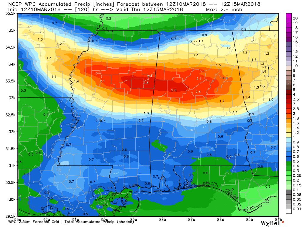
Rainfall amounts could be fairly heavy across Central Alabama with amounts of 1.5 to 2.5 inches possible across a sizable chunk of Central Alabama stretching from Pickens County across Tuscaloosa and Jefferson counties into Calhoun County (see map below).
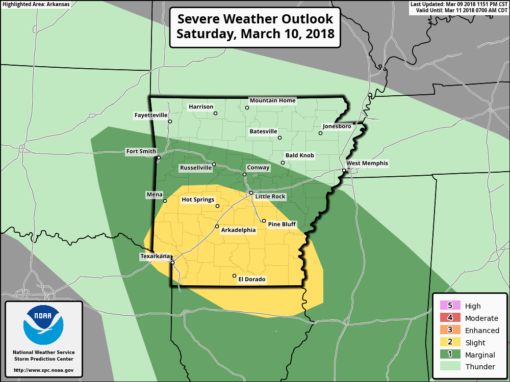
Risk of severe storms remains primarily to the west of Central Alabama across southern Arkansas and northern Louisiana. The main threat from this situation appears to be large hail and damaging wind, however, wind profiles later this evening do support the potential for an isolated tornado or two.
The closed low at 500 millibars over western South Dakota today will dig into southern Missouri by midday on Sunday as the surface low moves eastward across Alabama. This should bring an end to precipitation for us by Sunday evening. The closed low will continue to dig into the Carolinas bringing the flow aloft around to the northwest for us. After a high in the 60s on Sunday we’ll probably struggle to reach a high in the lower 50s on Monday.
The upper trough will remain in place through Thursday keeping our flow out of the northwest aloft while a surface high gradually settles into the Southeast US from the Dakotas by Thursday. This will mean another string of rather chilly mornings from Tuesday through Thursday with lows once again dipping to the freezing mark.
By Friday a ridge pushes into the eastern US in response to a deep trough digging into southern California. This should really warm us back up with the highs on Friday pushing toward the 70-degree mark. Ridging remains the main feature Saturday, but it looks like we could see another round of rain with the next system coming out of the Southwest US as it taps into Pacific moisture aloft with a good southerly flow at the surface. Temperatures will remain warm with highs near 70.
Looking into Week 2, or voodoo country, the big take-away is the idea that the pattern will remain active. We see a strong trough moving through the Ohio River Valley on March 19th, but this one does not dig into the eastern US as deeply as the one in the week ahead. That is followed by a very strong ridge around the 21st that should spell a couple of days of very warm temperatures. But another strong short wave moving across the Middle Mississippi Valley around March 22n/23rd promises a round of wet, possibly stormy, weather before another ridge sets up by the 25th of March.
Beach Forecast: Click here to see the AlabamaWx Beach Forecast Center page.
WeatherBrains: Don’t forget you can listen to our weekly 90 minute netcast anytime on the web, or on iTunes. This is the show all about weather featuring many familiar voices, including our meteorologists here at ABC 33/40.
Don’t forget the jump to Daylight Saving Time happens tonight at 2 am, so be sure to set your clocks ahead before you head to bed. I expect to have the next Weather Xtreme Video posted here first thing on Sunday morning. Godspeed.
-Brian-
.
Category: Alabama's Weather, ALL POSTS, Weather Xtreme Videos
About the Author (Author Profile)
Brian Peters is one of the television meteorologists at ABC3340 in Birmingham and a retired NWS Warning Coordination Meteorologist. He handles the weekend Weather Xtreme Videos and forecast discussion and is the Webmaster for the popular WeatherBrains podcast.Subscribe
If you enjoyed this article, subscribe to receive more just like it.


