


RADAR CHECK: A light mix of rain and snow is falling this morning over parts of the Tennessee Valley region of far North Alabama. Temperatures there are above freezing and there is no impact.
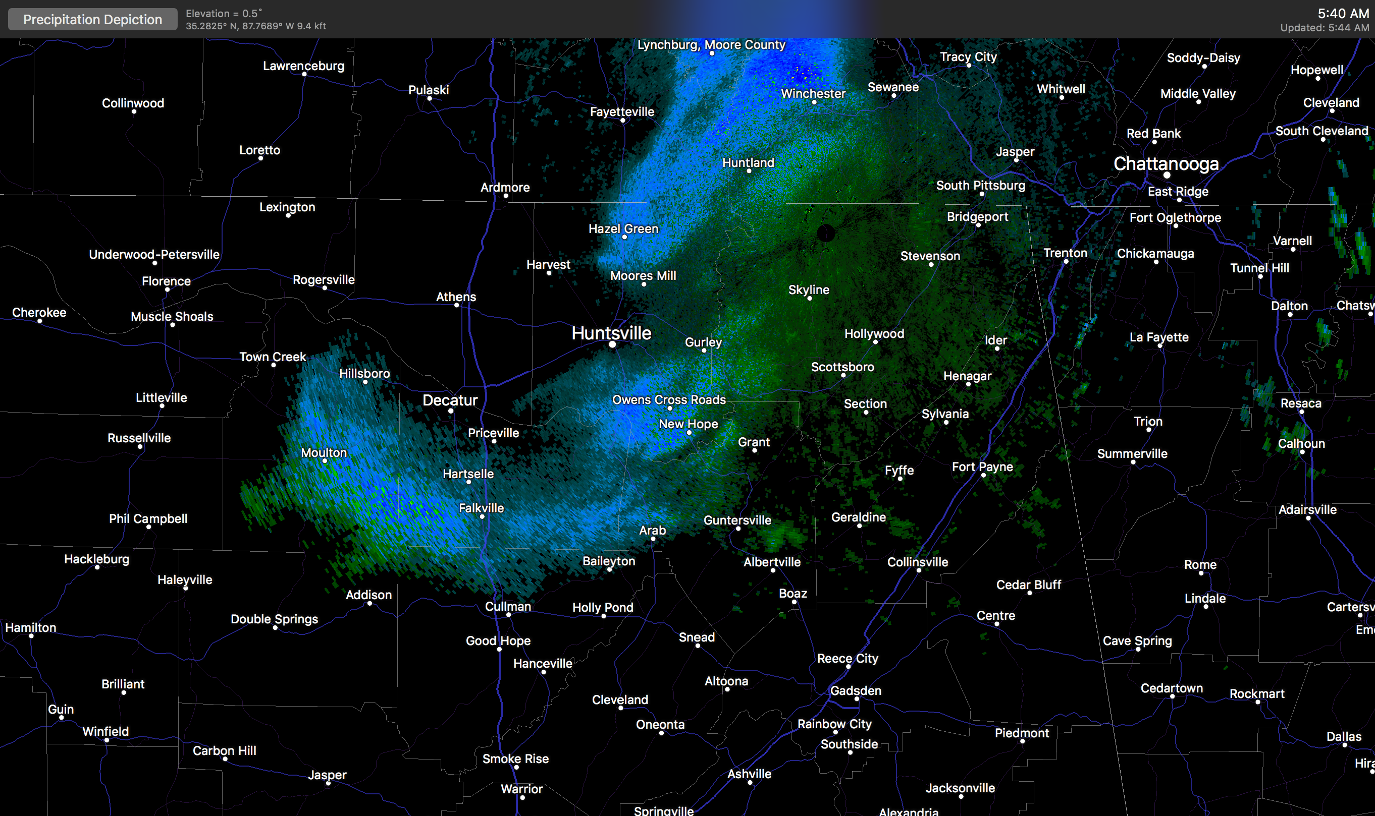
Precipitation will end later this morning, and the sky becomes mostly sunny later today as dry air takes over. A north wind of 15-25 mph will usher in colder air, and we won’t get past the mid 50s this afternoon.
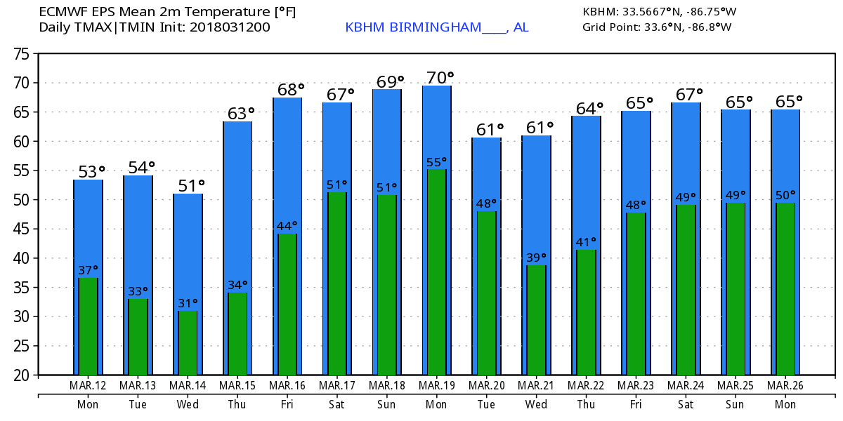
FREEZE WARNING: A freeze warning is in effect for much of North/Central Alabama for tonight and early tomorrow morning as temperatures are expected to drop to near 30 degrees. We also expect sub-freezing lows early Wednesday and Thursday mornings with lows in the 20s in many areas. Growers need to be ready to protect plants harmed by these kind of temperatures.
Our weather will be dry through mid-week with sunny days and clear nights; highs tomorrow and Wednesday will be in the 50s, but a warming trend begins Thursday afternoon with a high in the 60s. Friday will see some increase in clouds, but for now we will leave the forecast dry; the high Friday afternoon will be close to 70 degrees. Rain is possible by Friday night.
THE ALABAMA WEEKEND: Moist air returns to the state, and we expect mostly cloudy conditions over the weekend with a chance of showers and thunderstorms both days. With model inconsistency, it is too early to give specific timing on when the highest rain coverage will be. It won’t rain all weekend, but it certainly will rain at times with some thunder possible. For now we do not expect any problems with severe storms; rain amounts will be close to 1 inch over North Alabama, with lighter amounts for the southern counties of the state. Temperatures will be comfortable with afternoon highs in the low 70s.
NEXT WEEK: Mild and rather unsettled weather conditions will continue, at least for the first half of the week with a chance of showers and storms along with highs at or over 70 degrees… see the Weather Xtreme video for maps, graphics, and more details.
25 YEARS AGO TODAY: The great “Blizzard of 93” cranked up. That night heavy snow and wind gusts to 50 mph produced “white out” conditions across much of the state; 13 inches was the official snow total at Birmingham. Other totals included 20 inches at Walnut Grove, and 16 inches at Bessemer. Some snow drifts were almost three feet high. Some had no power for over a week, and everything was totally shut down in the middle of March.
We forecast 6-16 inches of snow, but few payed attention (and I don’t blame them since it was spring, after all)…
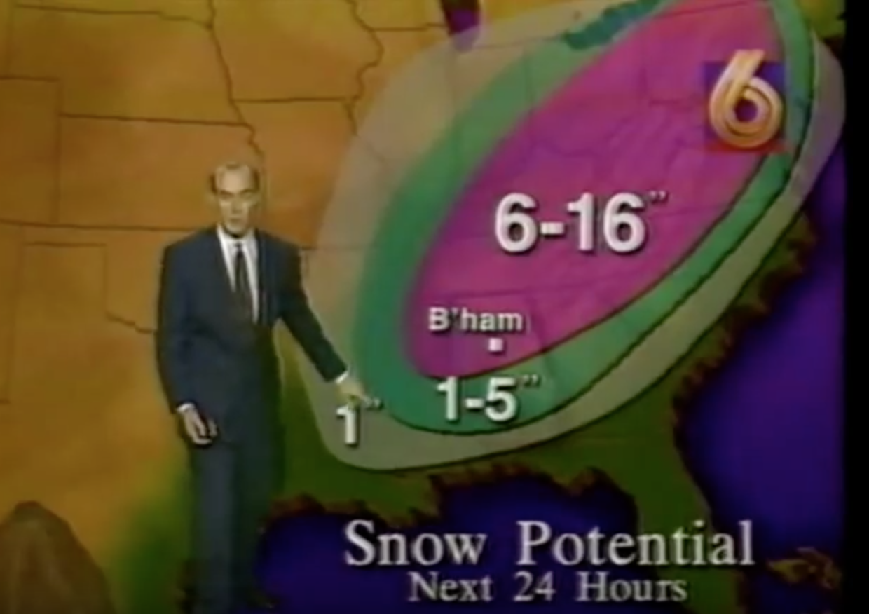
More on the 1993 blizzard later today.
BEACH FORECAST: Click here to see the AlabamaWx Beach Forecast Center page.
WEATHER BRAINS: Don’t forget you can listen to our weekly 90 minute netcast anytime on the web, or on iTunes. This is the show all about weather featuring many familiar voices, including our meteorologists here at ABC 33/40. We will produce this week’s show tonight at 8:30 CT… you can watch it live here.
CONNECT: You can find me on all of the major social networks…
Facebook
Twitter
Google Plus
Instagram
Pinterest
Snapchat: spannwx
I have a weather program this morning at Elvin Hill Elementary in Columbiana… look for the next Weather Xtreme video here by 4:00 this afternoon. Enjoy the day!


