

Freeze Warnings and Frost Advisory Issued for Early Thursday Morning; Protect Tender Vegetation
It is a chilly early morning across Central Alabama. Skies have cleared in most spots, allowing temperatures to fall into the 30s and lower 40s. Clouds have been slower to erode over Northeast Alabama, where they remain clouds across parts of Jackson and DeKalb Counties, but that clearing process should finish up around sunrise. A large patch of clouds moving out of Mississippi has kept places like Lamar, Fayette, Pickens and Tuscaloosa Counties a tad warmer. It is 43F at Tuscaloosa, 38f at Birmingham, 39F at Calera, 38F at Gadsden and 40F at Anniston.
A band of high clouds is moving across South Central Alabama, affecting places like Demopolis, Selma, and Montgomery.
The wind advisory for Central Alabama expired at 10 p.m. last night. Winds gusted to 30 mph at the Birmingham airport around 8:40 p.m. and gusts averaged between 20-30 mph nearly continuously from 11 a.m. until 11 p.m. They have calmed since then.
FROST ADVISORY AND FREEZE WARNINGS ISSUED FOR EARLY THURSDAY
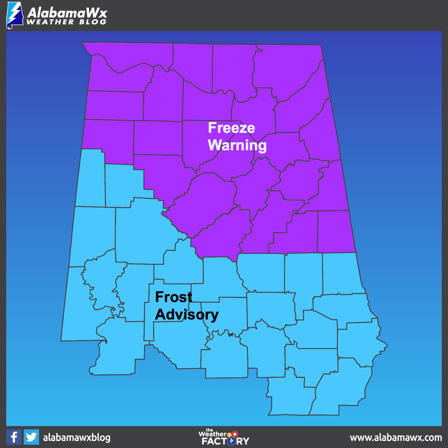
A freeze warning has been issued for the following Central Alabama counties: Blount, Calhoun, Cherokee, Clay, Cleburne, Etowah, Jefferson, Marion, Randolph, Shelby, St. Clair, Talladega, Walker and Winston Counties for Thursday morning.
The NWS Huntsville has also issued a Freeze Warning for the remaining counties in North Alabama including Colbert, Cullman, De Kalb, Franklin, Jackson, Lauderdale, Lawrence, Limestone, Madison, Marshall and Morgan.
Temperatures in the Freeze Warning area are expected to drop to between 26F and 32F by Thursday morning. This could kill crops and sensitive vegetation.
A Frost Advisory has been issued for Autauga, Barbour, Bibb, Bullock, Chambers, Chilton, Coosa, Dallas, Elmore, Fayette, Greene, Hale, Lamar, Lee, Lowndes, Macon, Marengo, Montgomery, Perry, Pickens, Pike, Russell, Sumter, Tallapoosa and Tuscaloosa for Thursday morning. Temperatures in the Frost Advisor area are expected to drop to between 32F and 36F by Thursday morning. This could kill crops and sensitive vegetation as well.
The warnings and advisory are in effect from 2 a.m. CDT until 8 a.m. CDT tomorrow morning.
Category: Alabama's Weather, ALL POSTS
About the Author (Author Profile)
Bill Murray is the President of The Weather Factory. He is the site's official weather historian and a weekend forecaster. He also anchors the site's severe weather coverage. Bill Murray is the proud holder of National Weather Association Digital Seal #0001 @wxhistorianSubscribe
If you enjoyed this article, subscribe to receive more just like it.


