

Here’s What to Expect For the Rest of Tonight
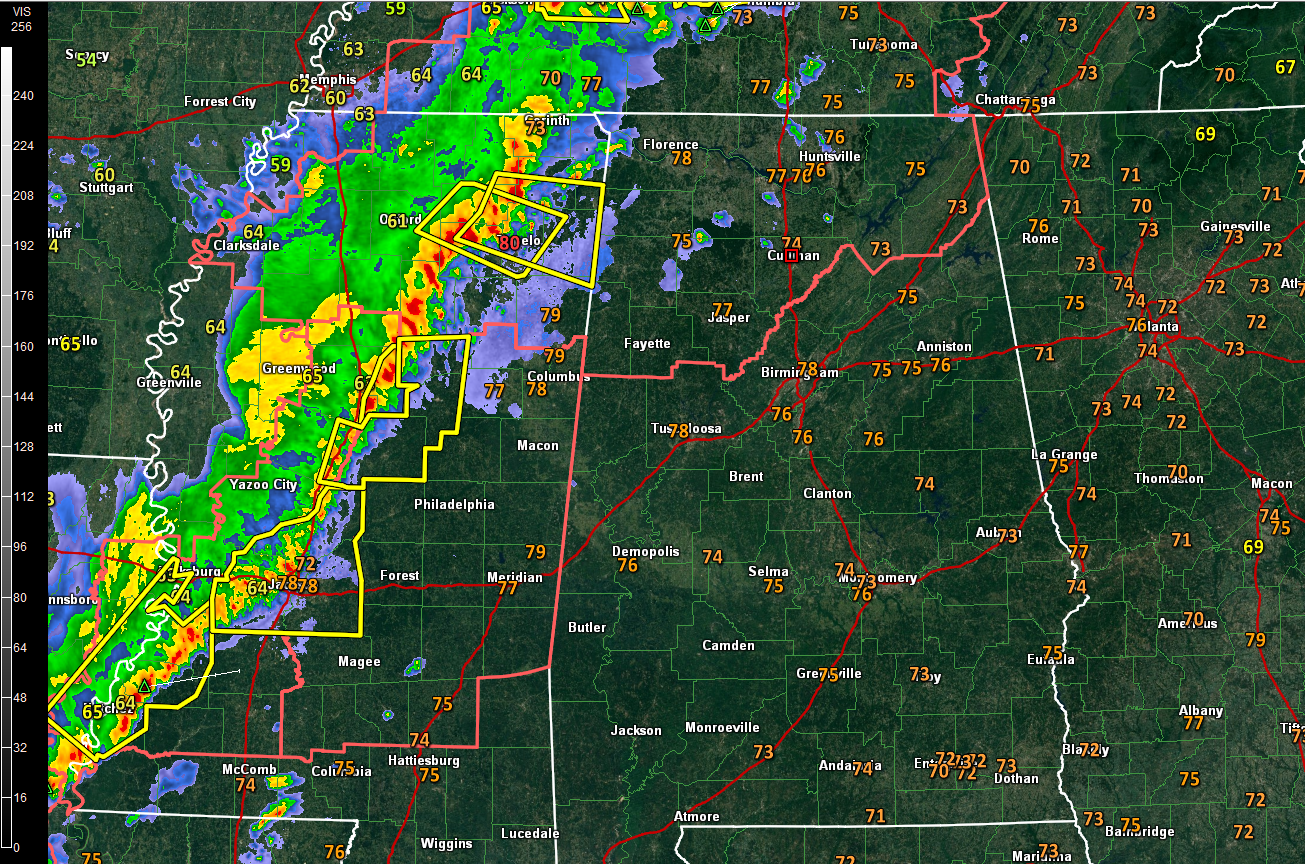
At 8:30 p.m., our line of thunderstorms is about 45 miles west of the Colbert/Franklin County border, about 7 5miles west of Hamilton and 80 miles west of Millport in Lamar County.
It is moving east at 45 mph.
Severe thunderstorm warnings extend all along the line, from just south of Memphis along the Mississippi River and back into Central Louisiana.
There has been some bowing of the line over northeastern Mississippi, raising the prospect that damaging winds are more likely with that segment. A severe thunderstorm warning is in effect for Tupelo now. A new warning just extended this damaging wind threat to the border of Franklin and Marion Counties.
Damage is being reported around New Albany, Mississippi.
A new warning was just issued for parts of Choctaw, Holmes, Attala and Webster counties in eastern Mississippi, including Kosciusko, Ackerman, and Durant. This puts the warnings within two counties of Lamar and Pickens Counties in Alabama.
The storms will arrive in…
…Red Bay between 9 p.m. and 10 p.m.
…Fayette by 10:30 to 11 p.m.
…Jasper by 11:30 p.m. to midnight
…Cullman by midnight to 12:30 a.m.
…Aliceville by 10:30-11 p.m.
…Tuscaloosa by 11:30 p.m. to midnight
…Birmingham by midnight to 1 a.m.
…Gadsden/Anniston between 1 a.m. and 2 a.m.
Damaging winds are the primary threat along with a smaller threat of large hail. There is a small, but not zero threat of a couple of tornadoes.
Dewpoints fell with the strong heating of the day this afternoon, but are recovering on the backs of the brisk southwesterly winds ahead of the cold front. Instabilities have correspondingly been low to moderate but could hold steady despite the loss of heating.
Wind shear is increasing as strong upper-level winds spread eastward ahead of the front.
There is a small amount of low-level helicity over Northwest Alabama, but surface winds are all veered to the southwest, which typically doesn’t support tornadoes. Lifted condensation levels are high as well because of the low dewpoints, which indicates a lower tornado threat as well. But the storms will still pack and mean punch and can kill with damaging winds, flipping mobile homes or bringing trees crashing down.
Mid-level lapse rates are high over Central Mississippi indicating a better chance of large hail with those storms later. As the storms get into slightly higher instability east of I-65 tonight, there could be some larger hail as well.
Unlike some of our recent low topped supercells, these storms have plenty of lightning.
A severe thunderstorm watch continues until 1 a.m. for 16 counties across North and Northwest Alabama.
The cold front is approaching Memphis at this hour. There is a sharp temperature gradient across the front, with readings dropping 20 degrees very quickly following its passage.
Category: Alabama's Weather, ALL POSTS
About the Author (Author Profile)
Bill Murray is the President of The Weather Factory. He is the site's official weather historian and a weekend forecaster. He also anchors the site's severe weather coverage. Bill Murray is the proud holder of National Weather Association Digital Seal #0001 @wxhistorianSubscribe
If you enjoyed this article, subscribe to receive more just like it.


