

Dry Through Friday; Storms Saturday
PLEASANT SPRING AFTERNOON: The sky has become partly to mostly sunny this afternoon with temperatures in the 67-70 degree range in most places; nothing show up on radar. Clouds will increase tonight, and a bit of light rain is possible over the southern half of the state… but where rain falls there amounts should be generally under one tenth of an inch.
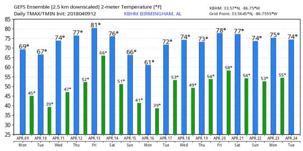
Tomorrow will be a mostly sunny day with a high in the 60s, below the average high of 73 for April 10.
CHILLY TEMPERATURES EARLY WEDNESDAY: We project a low early Wednesday in the 38-42 degree range… but some of the traditionally colder spots could see some frost with low to mid 30s. Then, during the day Wednesday, we expect sunshine in full supply with a high close to 70 degrees.
THURSDAY/FRIDAY: Our weather stays dry on these two days with warmer afternoons; highs will be close to 80 degrees with a good supply of sunshine. But, to the west, Friday looks like an active severe weather day for parts of East Texas, East Oklahoma, much of Arkansas, and North Louisiana… this is where SPC has a severe weather risk defined…

THE ALABAMA WEEKEND: Showers and storms will move into Alabama on Saturday as the weekend begins, and some of the storms could pack a punch. For now it looks like the main issue will come from strong straight line winds as the surface low should be far to the north over the Great Lakes. There are still some model differences, but it looks like the main window for rain and storms will come from 12:00 noon Saturday through 12:00 midnight Saturday night. Rain could possibly linger into Sunday morning.
Sunday looks like a cloudy, breezy, and much cooler day with some light rain still possible on the back side of the departing system. A good chance temperatures will hold in the 50s all day over the northern half of the state.
NEXT WEEK: The first half of the week looks dry with cold mornings. We will drop into the 37-41 degree range early Monday, but the coldest morning could very well come on Tuesday April 17 with most North/Central Alabama communities dropping into the 30s with a chance of frost. On the positive side, this looks like the last widespread frost of the season. See the Weather Xtreme video for maps, graphics, and more details.
BEACH FORECAST: Click here to see the AlabamaWx Beach Forecast Center page.
WEATHER BRAINS: Don’t forget you can listen to our weekly 90 minute netcast anytime on the web, or on iTunes. This is the show all about weather featuring many familiar voices, including our meteorologists here at ABC 33/40. We will produce this week’s show tonight at 8:30 CT… you can watch it live here.
CONNECT: You can find me on all of the major social networks…
Facebook
Twitter
Google Plus
Instagram
Pinterest
Snapchat: spannwx
I really enjoyed seeing the second graders at Pinson Elementary this morning… be looking for them on the Pepsi KIDCAM today at 4:00 on ABC 33/40 News! The next Weather Xtreme video will be posted here by 7:00 a.m. tomorrow…
Category: Alabama's Weather, ALL POSTS, Weather Xtreme Videos
About the Author (Author Profile)
James Spann is one of the most recognized and trusted television meteorologists in the industry. He holds the AMS CCM designation and television seals from the AMS and NWA. He is a past winner of the Broadcast Meteorologist of the Year from both professional organizations.Subscribe
If you enjoyed this article, subscribe to receive more just like it.


