Close To 80 By Thursday/Friday; Storms This Weekend
COOL NIGHT AHEAD: This has been a picture perfect spring day across the great state of Alabama; with sunshine in full supply temperatures are in the 68-72 degree range this afternoon. Tonight will be clear and cool; most places across North/Central Alabama will drop into the low 40s early tomorrow, but traditionally colder spots will dip down toward the mid 30s with some scattered light frost possible there.
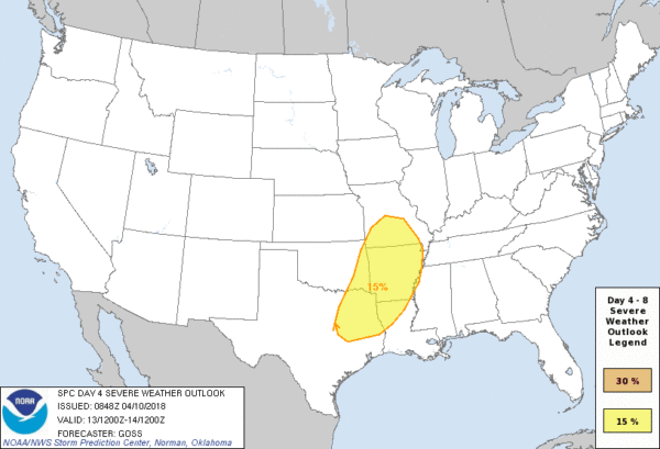
TOMORROW THROUGH FRIDAY: Our weather stays dry on these three days; the high tomorrow will be in the low 70s, followed by 80 degree warmth Thursday and Friday afternoon. The sky will be sunny tomorrow and Thursday; Friday will be partly sunny with a good south wind developing ahead of a storm system to the west. There is a severe weather risk Friday and Friday night over most of Arkansas and some of the adjacent states…
STORMS ARRIVE THIS WEEKEND: Confidence in a healthy round of rain and storms this weekend in Alabama is high, but there are still many questions about the details this far out. Global models are still not in good agreement; the American model (GFS) shows rain and storms rolling into the state Saturday morning, but the European global model (ECMWF) is much slower, showing most of the rain coming late Saturday afternoon, Saturday night, and into Sunday morning.
For now, we will lean toward the slower EC model and suggest the main 24 hour window for rain and storms will come from 12:00 noon Saturday through 12:00 noon Sunday. Understand it won’t rain for that entire 24 hour period, of course. We should be able to narrow down the time frame as the weekend gets closer. Rain amounts of 1-2 inches are likely.
Some of the storms over the weekend could be strong to severe. Again, with models in disagreement now it makes it very challenging to provide a clear assessment of the risk, but at this moment it looks like the primary threat will come from strong straight line winds, but a few isolated tornadoes can’t be totally ruled out based on forecast wind profiles. Some hail will be possible as well.
Once we get within 60 hours of the event details will be become clearer as we can look at it with the CAMs (convection allowing models). Much cooler air will follow the storms Sunday; temperatures should fall into the 50s by afternoon with a brisk north wind.
NEXT WEEK: The first half of the week will be dry with chilly mornings; lows will drop into the low 40s early Monday, and we will continue to monitor for frost potential early Tuesday (April 17) with a clear sky and light wind. See the Weather Xtreme video for maps, graphics, and more details.
ON THIS DATE IN 2009: An EF-3 tornado stayed on the ground for 33 miles through parts of Marshall, Jackson, and DeKalb Counties with many houses heavily damaged in the area along Lake Guntersville and in subdivisions to the east, with a few destroyed. Many mobile homes and boat houses were also destroyed along its path. Five people were injured, at least 20 boat houses were destroyed.
BEACH FORECAST: Click here to see the AlabamaWx Beach Forecast Center page.
WEATHER BRAINS: Don’t forget you can listen to our weekly 90 minute netcast anytime on the web, or on iTunes. This is the show all about weather featuring many familiar voices, including our meteorologists here at ABC 33/40.
CONNECT: You can find me on all of the major social networks…
Facebook
Twitter
Google Plus
Instagram
Pinterest
Snapchat: spannwx
I had a great time today visiting with the 6th graders at Goshen Elementary in Pike County… be looking for them on the Pepsi KIDCAM today at 5:00 on ABC 33/40 News! The next Weather Xtreme video will be posted here by 7:00 a.m. tomorrow…
Category: Alabama's Weather, ALL POSTS, WeatherBrains


