

A Quick 12:30 PM Update: Strong To Severe Storms Continue To Move Across Central Alabama
Radar Check At 12:22 PM

The line of strong to severe storms have entered the western parts of the area and are starting to move into the Cullman, Walker, and Tuscaloosa counties. We have several Severe Thunderstorm Warnings along the line with damaging winds being the main threat. There is a Tornado Warning in effect for parts of Greene and Pickens counties that could be extended into Tuscaloosa County.
Severe Weather Outlook For Today & Tonight

The western half of Central Alabama is defined in an Enhanced Risk (level 3 of 5) for severe storms throughout the remainder of your Saturday, with the exception of the locations closest to the Mississippi state line. The rest of the area is in a Slight Risk (level 2 of 5) for severe storms.
Threats for the enhanced risk areas include a few tornadoes (some of which could be strong) and damaging winds up to 70 MPH. Threats for the slight risk areas are damaging winds up to 60 MPH and a brief tornado or two. For the marginal risk areas, the threat is much smaller than the slight risk area, but not zero.
Timing For Strong To Severe Storms
The main window for strong to severe storms throughout the area will be from now until around 2:00 AM Sunday.
For the western parts of the area (Hamilton, Tuscaloosa, Demopolis), the window will be from 11:00 AM to 5:00 PM.
For the central parts of the area (Birmingham, Clanton, Selma), the window will be from 3:00 PM to 8:00 PM.
For the east-central parts of the area (Montgomery, Alexander City, Anniston), the window will be from 5:00 PM to 11:00 PM.
For the eastern parts of the area (Auburn, Troy, Eufaula), the window will be from 9:00 PM until 2:00 AM.
Once the leading stronger storms on the front of the line passes your location, your severe weather threat will have ended. We still have the risk for excessive rainfall, so Flash Flood Warnings may be issued.
Tornado Watch Issued For Parts Of Central Alabama
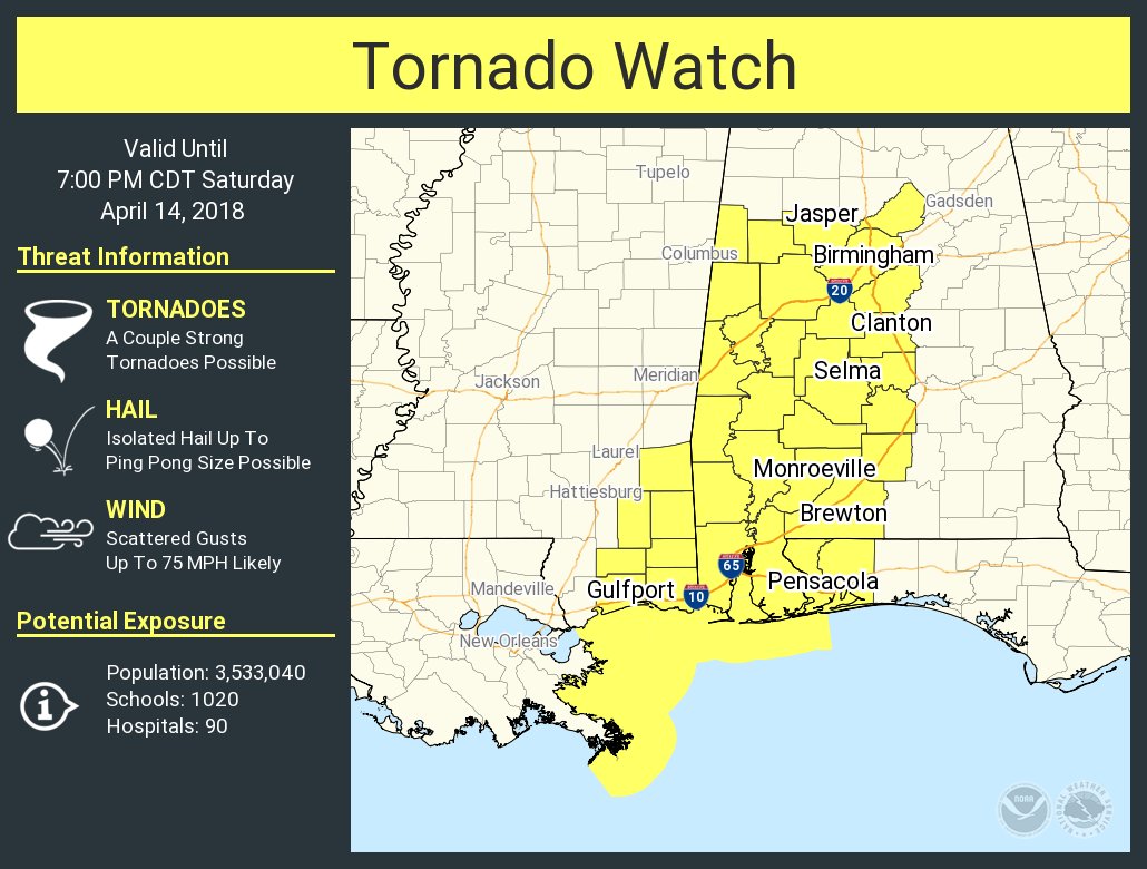
The Storm Prediction Center, in conjunction with NWS Birmingham has issued a Tornado Watch for a good portion of Central Alabama until 7:00 PM tonight. This watch includes the counties of Autauga, Bibb, Blount, Chilton, Dallas, Fayette, Greene, Hale, Jefferson, Lamar, Lowndes, Marengo, Perry, Pickens, Shelby, Sumter, Tuscaloosa, and Walker.
Continue to check back on AlabamaWx.com for any breaking updates on the ongoing weather situation.
Category: Alabama's Weather, ALL POSTS
About the Author (Author Profile)
Scott Martin is an operational meteorologist, professional graphic artist, musician, husband, and father. Not only is Scott a member of the National Weather Association, but he is also the Central Alabama Chapter of the NWA president. Scott is also the co-founder of Racecast Weather, which provides forecasts for many racing series across the USA. He also supplies forecasts for the BassMaster Elite Series events including the BassMaster Classic.Subscribe
If you enjoyed this article, subscribe to receive more just like it.


