

New Tornado Watch In The South; Old Watches Cancelled Or Expired
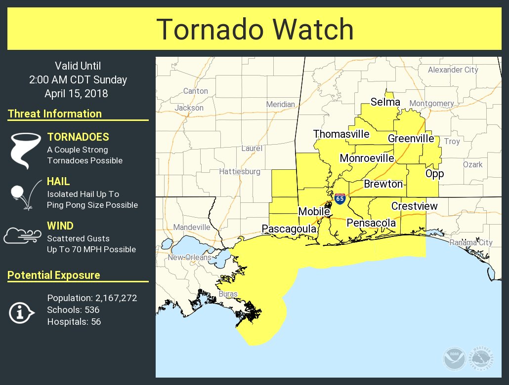
The Storm Prediction Center has issued a Tornado Watch for portions of Southern and a small part of Central Alabama, the Florida Panhandle, far southeast Mississippi, and the coastal waters effective this Saturday night and Sunday morning from 6:50 PM until 2:00 AM CDT. This new watch replaces the old watch for Dallas and Lowndes counties in the southern parts of Central Alabama.
Primary threats include a few tornadoes and a couple intense tornadoes possible, and scattered damaging wind gusts to 70 mph possible.
SUMMARY…Storms are expected to persist and gradually intensify along composite outflow across the region with a gradual east/northeastward acceleration this evening. Increasing low-level shear and the presence of a weak area of low pressure will maintain long/somewhat curved low-level wind profiles supportive of a quasi-linear convective mode with embedded supercells/mesovortices capable of a few tornadoes along with damaging winds.
REMEMBER…A Tornado Watch means conditions are favorable for tornadoes and severe thunderstorms in and close to the watch area. Persons in these areas should be on the lookout for threatening weather conditions and listen for later statements and possible warnings.
The previous Tornado Watch for Central Alabama was allowed to expire as the organized severe weather threat has diminished. A few strong or marginally severe storms still remain possible, but the threat for those will be rather low.
NWS Huntsville cancels a Flash Flood Watch that was in effect for Colbert, Cullman, Franklin, Lauderdale, Lawrence, Limestone, and Morgan counties until 1:00 AM Sunday. The threat of flash flooding has diminished as the heaviest rainfall is now south and east of the area. However, additional light to moderate rainfall could cause river and small stream levels to rise to minor flood stage.
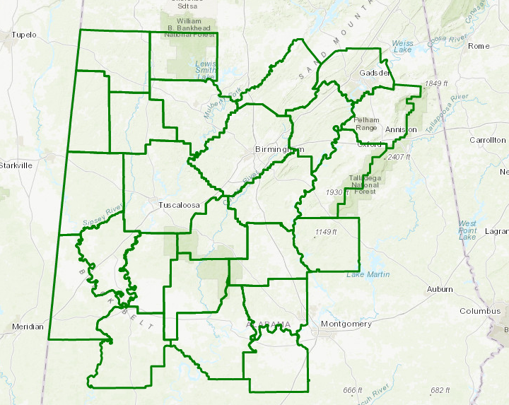
A Flash Flood Watch continues until 1:00 AM Sunday for Autauga, Bibb, Blount, Calhoun, Chilton, Coosa, Dallas, Etowah, Fayette, Greene, Hale, Jefferson, Lamar, Lowndes, Marengo, Marion, Perry, Pickens, Shelby, St. Clair, Sumter, Talladega, Tuscaloosa, Walker, and Winston counties. Rainfall amounts of 3 to 4 inches could lead to isolated flash flooding into tonight.
Category: Alabama's Weather, ALL POSTS
About the Author (Author Profile)
Scott Martin is an operational meteorologist, professional graphic artist, musician, husband, and father. Not only is Scott a member of the National Weather Association, but he is also the Central Alabama Chapter of the NWA president. Scott is also the co-founder of Racecast Weather, which provides forecasts for many racing series across the USA. He also supplies forecasts for the BassMaster Elite Series events including the BassMaster Classic.Subscribe
If you enjoyed this article, subscribe to receive more just like it.


