

Cooler but Still Gorgeous
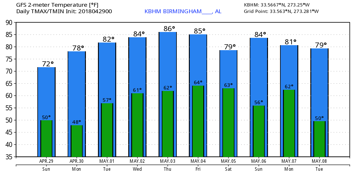
After hitting a high of 80 yesterday, we will be a little cooler today thanks to a frontal passage overnight, but the weather will still be gorgeous. Highs this afternoon should be about 10 degrees cooler with values reaching to around 70 – very nice indeed.
The upper air flow stays northwesterly overnight while a surface high centered near Chicago this morning settles to the southeast by Monday morning paving the way for good radiational cooling with lows dipping well into the 40s. Once again, this sets up conditions for some of the typically colder spots to reach the middle and upper 30s with the potential for patchy frost. Frost is not likely to be widespread enough for a frost advisory.
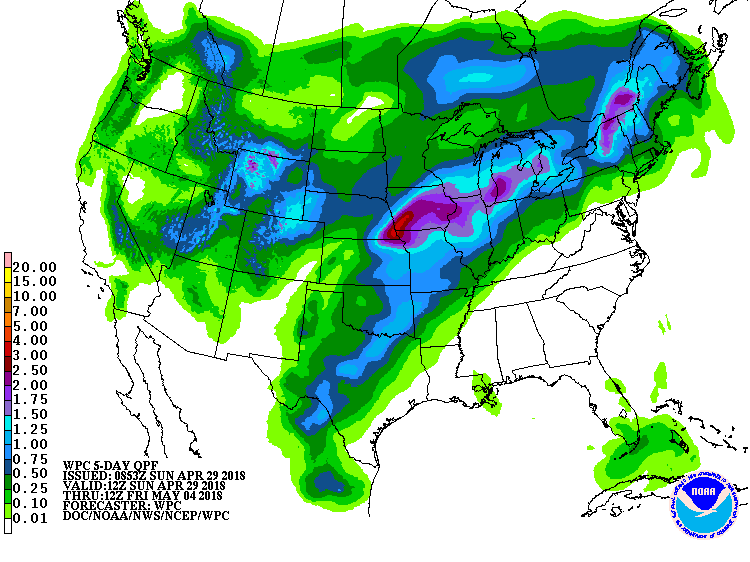
The upper flow by Monday afternoon begins to come under the influence of a ridge as it crosses the Mississippi River. At the surface the high will be centered over the Carolinas. It is this pattern of a ridge over the eastern US and the surface high centered near Bermuda but nosing westward across the Southeast US that will be the primary features for the week ahead. So expect dry conditions and warm afternoons with highs in the 80s and lows mainly in the 60s. As the QPF chart shows, no rain expected through Friday morning.
The pattern finally begins to change from Thursday into Friday as a strong upper trough over the Central Rockies on Thursday moves into the Ohio River Valley on Friday bringing a cold front into the Southeast US by the latter part of Friday. Timing on the latest model run suggests much of Friday will be dry, but by late afternoon and evening, there will be a low probability of showers, something in the 20 to 40 percent range.
The model run yesterday suggested the front would stall, but that is off the table this morning as the upper trough beats down the ridge enough to bring a weak northwesterly flow to the eastern US pushing the front well down to the Gulf Coast. This should mean a much better weekend for the northern two-thirds of Alabama than what we saw yesterday. With a weak northwesterly flow aloft temperatures are not forecast to drop back much with highs over the weekend around 80 degrees.
Looking out into voodoo country, the somewhat anomalous pattern we saw yesterday is gone in the run. Instead we see a nice ridge to begin the extended period on May 9th with a fairly strong short wave trough forecast to move from near the Four Corners area to northern Ohio by May 14th. This pattern is much less unsettled with the potential for a front in the area around May 13th. But you know how it goes, voodoo often changes dramatically from one run to the next as we see between yesterday and today.
Beach Forecasts: Click here to see the AlabamaWx Beach Forecast Center page.
WeatherBrains: Don’t forget you can listen to our weekly 90 minute netcast anytime on the web, or on iTunes. This is the show all about weather featuring many familiar voices, including our meteorologists here at ABC 33/40.
It was great to greet folks at the Celebrate Hoover event at Veterans Park yesterday. What great weather to come to the park for some music, rides for the kids, antique cars, and plenty of food choices for just about any appetite. James Spann will be back with the next edition of the Weather Xtreme Video bright and early to start your work week tomorrow. Have a great day and Godspeed.
-Brian-
Category: Alabama's Weather, ALL POSTS, Weather Xtreme Videos
About the Author (Author Profile)
Brian Peters is one of the television meteorologists at ABC3340 in Birmingham and a retired NWS Warning Coordination Meteorologist. He handles the weekend Weather Xtreme Videos and forecast discussion and is the Webmaster for the popular WeatherBrains podcast.Subscribe
If you enjoyed this article, subscribe to receive more just like it.


