

NHC Gives Disturbance A High Chance Of Developing Into A Depression

Here is the latest outlook from the NHC on the disturbance in the Caribbean Sea:
Special Tropical Weather Outlook
NWS National Hurricane Center Miami FL
710 PM EDT Wed May 23 2018
A broad surface low centered over the southeastern Yucatan Peninsula has become better defined since yesterday, and it continues to produce a large area of cloudiness and showers extending from the northwestern Caribbean Sea across Cuba into the Florida Straits. Continued slow development of this system is possible during the next couple of days as it drifts northward near the Yucatan Peninsula. Thereafter, environmental conditions are forecast to become more conducive for development, and a subtropical or tropical depression is likely to form this weekend over the eastern or central Gulf of Mexico. Regardless of development, locally heavy rainfall is possible across western Cuba and the Cayman Islands during the next few days, and over much of Florida and the northern Gulf Coast during the weekend.
* Formation chance through 48 hours…low…10 percent.
* Formation chance through 5 days…high…70 percent.
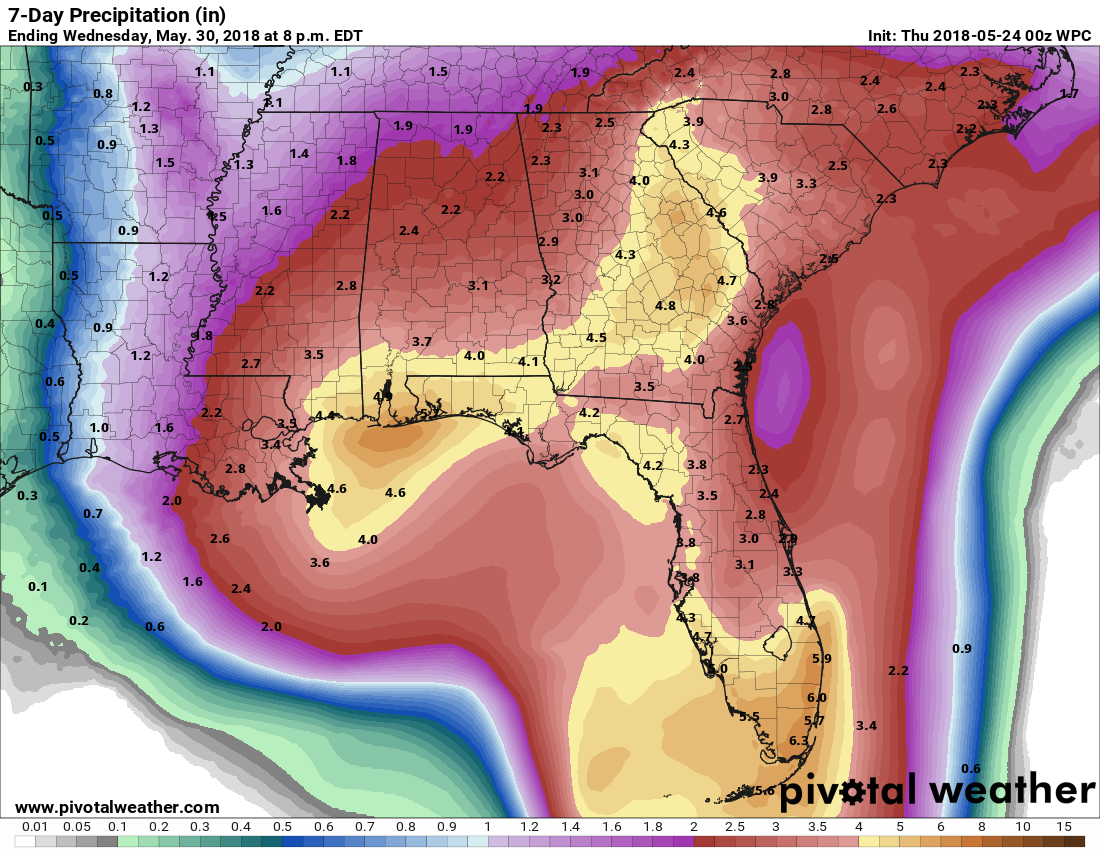
What this means for Central Alabama is that our rain chances will become enhanced starting on Saturday and will persist throughout the weekend and into the beginning of next week. Rainfall totals from now through Wednesday evening could total from just below 2.00″ in the northern parts of the state, to over 4.00″ over the extreme southern parts of the state. Some localized totals could be even higher if the European model solution holds true and the system meanders over the northern Gulf for a couple of days before moving through the western parts of the state when it finally pushes to the north.
If heading to the beach, remember to pay attention to the flags. Dangerous rip currents are expected to occur along the Gulf Coast. If the flags are red, stay out of the water.
With a great amount of uncertainty with where landfall or intensity, it will be difficult to forecast where exactly the heavier rain amounts will occur. We’ll know with better details in a day or two. Also, there should be some decent intervals of sun and dry weather on the coast mixed in as well.
The good news is that the disturbance is not expected to reach tropical storm or hurricane strength. With that being said, a tropical depression can dump copious amounts of rain.
Category: Alabama's Weather, ALL POSTS
About the Author (Author Profile)
Scott Martin is an operational meteorologist, professional graphic artist, musician, husband, and father. Not only is Scott a member of the National Weather Association, but he is also the Central Alabama Chapter of the NWA president. Scott is also the co-founder of Racecast Weather, which provides forecasts for many racing series across the USA. He also supplies forecasts for the BassMaster Elite Series events including the BassMaster Classic.Subscribe
If you enjoyed this article, subscribe to receive more just like it.


