

We Say Hello To Subtropical Storm Alberto

Latest from the National Hurricane Center…
PRE-SEASON SUBTROPICAL STORM ALBERTO FORMS OVER THE NORTHWESTERN CARIBBEAN SEA
HEAVY RAINFALL EXPECTED TO AFFECT THE YUCATAN PENINSULA, WESTERN CUBA, FLORIDA, AND THE NORTHEASTERN GULF COAST THROUGH THE WEEKEND
SUMMARY OF 1000 AM CDT…1500 UTC…INFORMATION
———————————————–
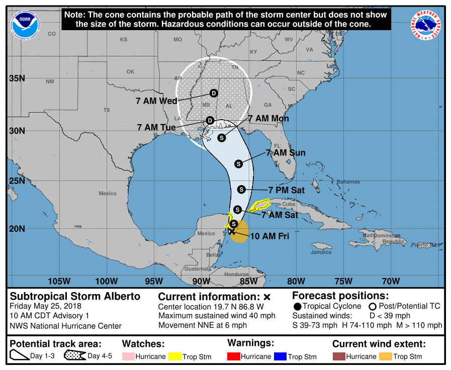
LOCATION…19.7N 86.8W
ABOUT 55 MI…90 KM S OF COZUMEL MEXICO
ABOUT 195 MI…315 KM SW OF THE WESTERN TIP OF CUBA
MAXIMUM SUSTAINED WINDS…40 MPH…65 KM/H
PRESENT MOVEMENT…NNE OR 20 DEGREES AT 6 MPH…9 KM/H
MINIMUM CENTRAL PRESSURE…1005 MB…29.68 INCHES
WATCHES AND WARNINGS
——————–
CHANGES WITH THIS ADVISORY:
The Government of Mexico has issued a Tropical Storm Watch for the east coast of the Yucatan Peninsula from Tulum to Cabo Catoche.
The Government of Cuba has issued a Tropical Storm Watch for the western Cuban province of Pinar del Rio.
SUMMARY OF WATCHES AND WARNINGS IN EFFECT:
A Tropical Storm Watch is in effect for…
* Tulum to Cabo Catoche Mexico
* Cuban province of Pinar del Rio
A Tropical Storm Watch means that tropical storm conditions are possible within the watch area, in this case within the next 24 hours.
Interests along the central and eastern U.S. Gulf Coast should monitor the progress of Alberto. Tropical storm and storm surge watches could be required for portions of this area later today or tonight.
For storm information specific to your area, please monitor products issued by your national meteorological service.
DISCUSSION AND OUTLOOK
———————-
At 1000 AM CDT (1500 UTC), the center of Subtropical Storm Alberto was located near latitude 19.7 North, longitude 86.8 West. The storm is moving toward the north-northeast near 6 mph (9 km/h). A general slow motion toward the north is expected through the weekend, followed by a northwest turn by Monday. On the foreast track, Alberto is expected to pass near the eastern coast of the Yucatan peninsula tonight, be near the western tip of Cuba Saturday morning, emerge over the southeastern Gulf of Mexico by Saturday night, and approach the north-central Gulf Coast on Monday.
Maximum sustained winds are near 40 mph (65 km/h) with higher gusts. Gradual strengthening is forecast for the next 72 hours.
Winds of 40 mph extend outward up to 115 miles (185 km) from the center.
The estimated minimum central pressure is 1005 mb (29.68 inches).
HAZARDS AFFECTING LAND
———————-
RAINFALL: Alberto is expected to produce total rain accumulations of 10 to 15 inches with isolated totals of 25 inches across the northeastern portions of the Yucatan Peninsula and western Cuba. These rains could produce life-threatening flash floods and mudslides. Rainfall accmumulations of 4 to 8 inches with maximum amounts of 12 inches are possible across the Florida Keys and southern and southwestern Florida. Heavy rain will likely begin to affect the central Gulf Coast region and the southeastern Untied States later this weekend and continue into early next week. Flooding potential will increase across this region early next week as Alberto is forecast to slow down after it moves inland.
WIND: Tropical storm conditions are possible within the watch area through Saturday.
SURF: Swells generated by Alberto are affecting portions of the coast of eastern Yucatan Peninsula and western Cuba. These swells are likely to cause life-threatening surf and rip current conditions. Hazardous surf conditions are likely to develop along much of the central and eastern U.S. Gulf Coast this weekend. For more information, consult products from your local weather office.
NEXT ADVISORY
————-
Next intermediate advisory at 100 PM CDT.
Next complete advisory at 400 PM CDT.
Category: Alabama's Weather, ALL POSTS
About the Author (Author Profile)
Scott Martin is an operational meteorologist, professional graphic artist, musician, husband, and father. Not only is Scott a member of the National Weather Association, but he is also the Central Alabama Chapter of the NWA president. Scott is also the co-founder of Racecast Weather, which provides forecasts for many racing series across the USA. He also supplies forecasts for the BassMaster Elite Series events including the BassMaster Classic.Subscribe
If you enjoyed this article, subscribe to receive more just like it.


