

Tropical Storm Warnings Posted for the Alabama and Northwest Florida Coasts
Tropical storm warnings have now been posted for the coasts of Alabama and Northwest Florida in anticipation of Alberto.

The tropical storm warnings are shown in brick red.
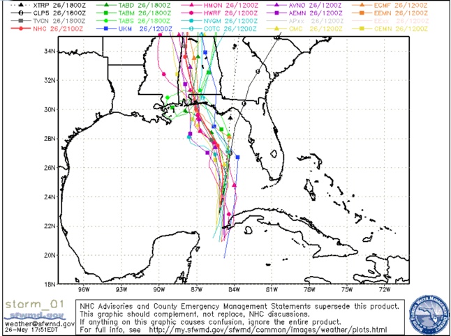
The new NHC track is shifted slightly east again and the models are leading that push.
Here is the latest model guidance:
The official forecast shows a landfall near Navarre/Pensacola on Monday afternoon at 4 p.m.

And carries it up through Southwest Alabama, to a position near Tuscaloosa Tuesday morning at 10 a..m., still barely a tropical storm with a small area of winds at 40 mph.
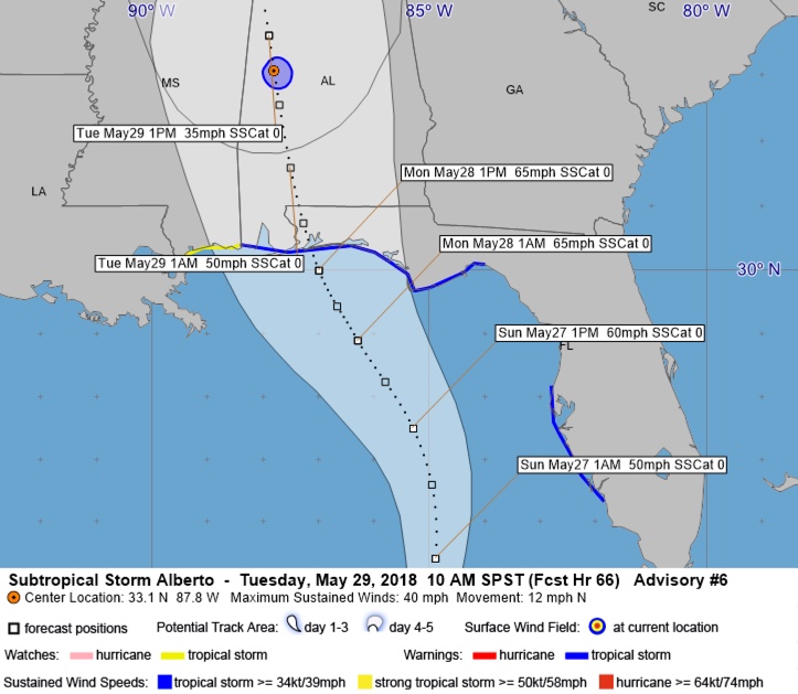
Alberto is expected to acquire tropical characteristics as it hooks up with an upper level low and shear reduces over it. This will allow it to strengthen to a strong tropical storm of 65 mph before landfall.
Conditions will begin to deteriorate by tomorrow morning across the Florida Panhandle, with clouds thickening and rain increasing from the southeast. Winds will increase during the afternoon as well.
The important thing it to focus on the impacts, including strong tropical storm force winds, flooding rains, storm surge, tornadoes and rip currents. Here are coastal impacts expected from Alberto.
ALABAMA COAST
Winds: 30-40 mph with gusts to 55 mph. Tropical storm conditions will begin early Monday afternoon continuing into the overnight. Peak winds should be from 5 p.m. Monday through 1 a.m. Tuesday.
Rainfall: 6-10 inches of rain possible causing flooding. Bands of rain will affect the coast starting early Sunday afternoon, with the most intense rain starting Monday afternoon and diminishing Monday night.
Storm Surge: 2-4 feet above ground level possible.
Tornadoes: A few tornadoes are possible Monday, but the best chance for tornadoes will be northeast of the center
WESTERN FLORIDA PANHANDLE including Pensacola and Navarre
Winds: 35-45 mph with gusts to 65 mph. Tropical storm conditions will begin early Monday afternoon continuing into the overnight. Peak winds should be from 5 p.m. Monday through 1 a.m. Tuesday.
Rainfall: 6-10 inches of rain possible causing flooding. Bands of rain will affect the coast starting early Sunday afternoon, with the most intense rain starting early Monday morning diminishing Monday night.
Storm Surge: 2-4 feet above ground level, especially along the coast near and east of the where the center makes landfall. Main storm surge impacts should be Monday.
Tornadoes: Tornadoes are possible with the circulation around Alberto on Monday into Tuesday.
CENTRAL FLORIDA PANHANDLE including Destin, Fort Walton, 30A
Winds: Winds will reach 45-55 mph with gusts to 75 mph. Tropical storm conditions will begin Monday morning and continue through Monday night. Peak winds will begin Monday afternoon through midnight Monday night.
Rainfall: Additional 4-8 inches causing flooding. Bands of rain will begin in the Destin area late Sunday morning and overspread the area Sunday afternoon but the most intense rainfall will begin early Monday morning and continue into monday night.
Storm Surge: 2-4 feet above ground level along the coast.
Tornadoes: Tornadoes are possible with the circulation around Alberto on Monday into Tuesday.
EASTERN FLORIDA PANHANDLE: Panama City/Rosemary
Winds: 25-35 with gusts above tropical storm force Monday morning, ending late Monday night
Rainfall: Additional 4-8 inches causing flooding. Heavy rain will begin in the Panama City area Sunday morning
Storm Surge: 2-4 feet above ground level along the coast.
Tornadoes: A few tornadoes are possible with the circulation around Alberto starting Sunday and continuing into Monday
Rip Currents: The threat for rip currents will be increasing through the weekend and will be high starting Sunday. Heed beach flags. When red flags are in place, stay out of the water. When double red flags are flying it is illegal to enter the water in many jurisdictions.
Alberto will bring significant impacts to Central Alabama starting Monday afternoon, including rain and wind. There could also be a few tornadoes. Scott Martin is preparing a detailed look at the impacts for Central Alabama.
We will bring you frequent updates throughout the weekend on the progress of Alberto.
Category: ALL POSTS
About the Author (Author Profile)
Bill Murray is the President of The Weather Factory. He is the site's official weather historian and a weekend forecaster. He also anchors the site's severe weather coverage. Bill Murray is the proud holder of National Weather Association Digital Seal #0001 @wxhistorianSubscribe
If you enjoyed this article, subscribe to receive more just like it.


