

Coastal Impacts Right Now Area by Area
Some recent reports from the coast:
…Winds gusted to 44 mph at St. George State Park at 8:27 am CDT.
…Winds gusted to 39 mph at945 am CDT near Apalachicola
…Winds gusted to 43 mph at Port St. Joe in Gulf County at 9:47 am CDT.
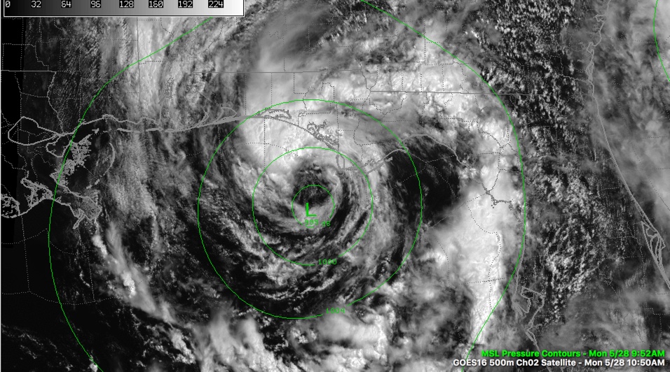
ALABAMA COAST
Cloudy with a little light rain right now. Northerly winds are running 10-15 mph gusting to 20 mph. Tides are running two feet above normal. A high surf advisory continues for Baldwin and Mobile Counties. Waves are running up to 5 feet and there is a high risk of rip currents. Additional rains will average one inch. There is no threat of severe weather.
PENSACOLA/NAVARRE
HIgh tide just occurred at Pensacola. Tides are running two feet above normal. Waves will be as high as 8 feet and the rip current risk is very high. A convective band is moving through Pensacola right now. There is a mix of rain and partly sunny skies in the area. Winds are northerly at 12-16 mph with gusts to 20-30 mph and will increase to 20-30 mph with higher gusts. Additional rainfall amounts will average 1-3 inches. There is no severe weather threat.
FORT WALTON/DESTIN
AN extended period of heavy rain is now moving into Destin. Winds will average 20-30 mph with gusts to 50 mph this afternoon. Additional rains will average 3-6 inches. Surf is running as high as 8 feet and storm surge is running two feet. The rip current risk is very high. There is a small chance for tornadoes.
30A/PANAMA CITY BEACH
Heavy convective bands are moving through Bay County right now. Surf is building to 10-13 feet and tides are running two feet above normal. The next high tide is Tuesday morning. Winds are averaging 15-25 mph out of the N and NE gusting to 30-35 mph. Winds could reach 30-40 mph with gusts to 50 mph this afternoon. An additional 3-6 inches of rain could fall. There is a small threat of tornadoes.
Stand by for a detailed look at Alberto’s impacts for Central Alabama.
Category: ALL POSTS
About the Author (Author Profile)
Bill Murray is the President of The Weather Factory. He is the site's official weather historian and a weekend forecaster. He also anchors the site's severe weather coverage. Bill Murray is the proud holder of National Weather Association Digital Seal #0001 @wxhistorianSubscribe
If you enjoyed this article, subscribe to receive more just like it.


