

Severe Storms Remain Possible Across Central Alabama
**No afternoon Weather Xtreme video due to the active weather in progress over Alabama**
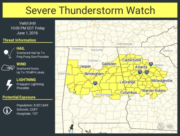
A severe thunderstorm watch remains in effect for much of Central Alabama until 9 p.m. CT…
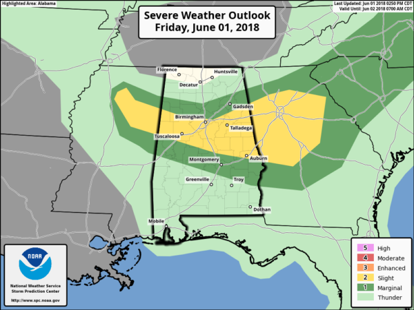
On the positive side, SPC has removed the “enhanced” severe weather risk (level 3 out of 5) for Alabama; we now have a “slight” risk… or level 2 out of 5…
Outflow from morning thunderstorms is pushing slowly southward, and the highest threat of strong to severe storms for the rest of the afternoon and evening hours will be mainly along and south a line from Millport to Warrior to Piedmont…

Storms across Central Alabama are still capable of producing hail, strong winds, frequent lightning, and torrential rain as they move eastward. The weather calms down after sunset.
THE ALABAMA WEEKEND: A few strong storms are possible tomorrow, but they should be pretty widely scattered, and mostly during the afternoon and evening hours. Otherwise, tomorrow will be partly sunny with a high close to 90 degrees. We note SPC has a “marginal” (level 1 out of 5) severe weather risk in place for much of the state… where storms do form tomorrow they could produce hail and gusty winds.

Then, on Sunday, a batch of storms is possible during the early morning hours (3-8 a.m.)… then drier air move into the northern counties of the state during the day; storms Sunday afternoon should be confined to the southern part of the state. The high Sunday will be in the mid to upper 80s.
ROCK THE SOUTH: The good news is that the threat of severe storms is over for Cullman County today, and we expect nothing more than widely scattered light rain showers through tonight. Temperatures will settle into the 70s tonight. Tomorrow, much of the day will be dry, hot, and humid with a high around 90. But, a brief passing storm can’t be ruled out tomorrow afternoon or tomorrow night.
U.S. WOMEN’S OPEN: There was a lightning delay today at Shoal Creek; a passing shower or storm remains possible for the rest of the afternoon. Tomorrow will be partly sunny, hot, and humid with the risk of an afternoon storm. But, much of the day will be dry. The high will be close to 90 degrees. Then, on Sunday, a morning shower is possible, but the afternoon will be dry with a high in the 85-88 degree range.
NEXT WEEK: A nice, dry, continental airmass rolls into the state Sunday night, and much of next week looks dry with sunny days, cool nights, and lower humidity levels. Highs will be in the 80s, lows around 60, and 50s are likely for cooler pockets.

BEACH FORECAST: Click here to see the AlabamaWx Beach Forecast Center page.
WEATHER BRAINS: Don’t forget you can listen to our weekly 90 minute netcast anytime on the web, or on iTunes. This is the show all about weather featuring many familiar voices, including our meteorologists here at ABC 33/40.
CONNECT: You can find me on all of the major social networks…
Facebook
Twitter
Google Plus
Instagram
Pinterest
Snapchat: spannwx
Look for my next Weather Xtreme video here by Monday morning at 7:00… Brian Peters will have the video updates tomorrow and Sunday. Enjoy the weekend!
Category: Alabama's Weather, ALL POSTS
About the Author (Author Profile)
James Spann is one of the most recognized and trusted television meteorologists in the industry. He holds the AMS CCM designation and television seals from the AMS and NWA. He is a past winner of the Broadcast Meteorologist of the Year from both professional organizations.Subscribe
If you enjoyed this article, subscribe to receive more just like it.


