

Storms Already Invading Parts Of The Area At Midday
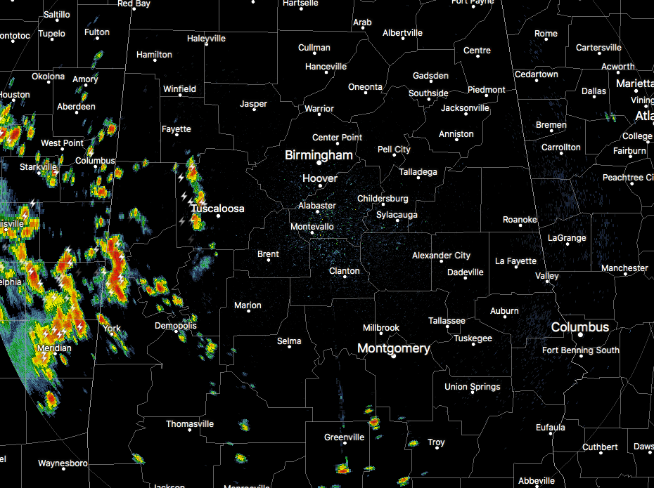
CONDITIONS ACROSS CENTRAL ALABAMA AT 11:55 AM
We have a good bit of scattered shower and thunderstorm activity that has fired up over the western parts of Central Alabama just before we reach the midday hour. Much of that activity was located over parts of Pickens, Sumter, Greene, and Tuscaloosa counties. These are moving just south of due east at xx MPH. At this point, these are good rain producers and pretty noisy with a good bit of lightning. We have a few more isolated showers out there, but we are quiet compared to Mississippi. Temperatures were in the upper 70s to the mid-80s at this point with the lower temperatures occurring in the parts that received heavy amounts of rain last night along with a little extra cloud cover hiding the sun.

The Storm Prediction Center has the northeastern corner of the state defined in a Marginal Risk for severe storms today through tonight, with the main risk being from damaging downburst winds. This is the more likely place where stronger storms will take place for today, but as we have seen with the past few days, we may have a few surprises after the sun sets.
WEATHER FOR THE REST OF YOUR MONDAY
We’ll continue to have scattered showers and storms develop throughout the afternoon and into the evening hours, some of which could be strong with gusty winds and some small hail. Most of these storms will have heavy downpours and dangerous cloud-to-ground lightning. Looks like today will not be much different than yesterday, so we may have one or two storms that could become severe briefly with downburst winds up to 60 MPH being the main threat. Some training of cells could occur as well, meaning that a few areal flood advisories or even a brief flash flood warning may be needed today. Afternoon highs will be in the upper 80s to the lower 90s. Storms should start to diminish somewhat during the evening and into the late night hours, but a few could persist into the overnight. Lows will be down in the upper 60s to the lower 70s. Some fog development is possible especially where heavy rainfall occurs today and tonight.
A CARBON COPY FORECAST FOR TUESDAY
Much of the same for the second day of the work week as we’ll continue to have hot, hazy, and humid conditions across Central Alabama. We’ll start of with some sun early, but convective clouds will start to build towards the end of the morning and into the early afternoon, with showers and thunderstorms developing just after that. Odds for storms at any one location will be higher than today, around 50/50 for the northwestern quarter of Central Alabama, and slightly higher for the rest of the area. Afternoon highs will be up into the upper 80s to the lower 90s, with lows in the upper 60s to the lower 70s. Same story… the main window for showers and storms will be from 12:00 PM to 10:00 PM with a few storms possibly forming earlier or hanging on a little later.

AN UPDATE ON THE TROPICS
At this point, the National Hurricane Center does not expect and tropical cyclone development within the next 5 days for the North Atlantic, Caribbean Sea, and the Gulf of Mexico.
BEACH FORECAST CENTER
Get the latest weather and rip current forecasts for the beaches from Fort Morgan to Panama City on our Beach Forecast Center page. There, you can select the forecast of the region that you are interested in.
WE’RE HAVING A RECORD-BREAKING YEAR… ADVERTISE WITH US TODAY!
Don’t miss out! We have enjoyed over 10.5 MILLION page views on AlabamaWx.com since the start of 2018. We can customize a creative, flexible and affordable package that will suit your organization’s needs. Contact Bill Murray at (205) 687-0782.
E-FORECAST
Get the AlabamaWx Weather Blog’s Seven-Day Forecast delivered directly to your inbox by email twice daily. It is the most detailed weather forecast available in Central Alabama. Subscribe here… It’s free!
WEATHERBRAINS
Don’t forget you can listen to our weekly 90 minute netcast anytime on the web at WeatherBrains.com or on iTunes. This is the show all about weather featuring many familiar voices, including the meteorologists at ABC 33/40.
ON THIS DAY IN WEATHER HISTORY
1989 – Thunderstorms produced severe weather in the south central and southeastern U.S. during the day and night. Thunderstorms spawned eleven tornadoes, including one which tore the roof off a restaurant at Bee Branch, AR, injuring six persons. The tornado tossed one car into the restaurant, and another car over it. Temperatures soared into the 90s across much of Florida. Lakeland reported a record high of 99 degrees for the second day in a row.
Category: Alabama's Weather, ALL POSTS
About the Author (Author Profile)
Scott Martin is an operational meteorologist, professional graphic artist, musician, husband, and father. Not only is Scott a member of the National Weather Association, but he is also the Central Alabama Chapter of the NWA president. Scott is also the co-founder of Racecast Weather, which provides forecasts for many racing series across the USA. He also supplies forecasts for the BassMaster Elite Series events including the BassMaster Classic.Subscribe
If you enjoyed this article, subscribe to receive more just like it.


