

Strong Storms Rolling Through The Northern Parts Of Central Alabama
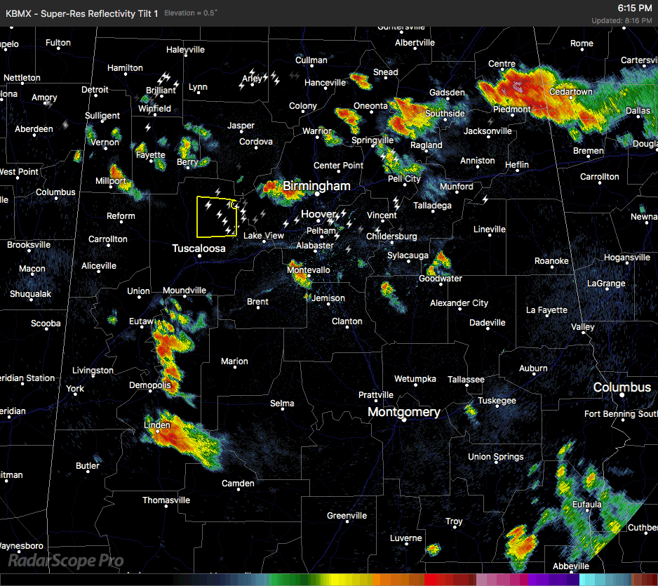
RADAR CHECK AT 8:15 PM: We currently have a Severe Thunderstorm Warning on a cluster of storms about to move into such communities as Bankhead Lock And Dam, Windham Springs, Lake Nicol, Lake Tuscaloosa, Sexton Bend and Lake Nicol Park. The threats with this cluster will be wind gusts up to 60 MPH and dangerous cloud-to-ground lightning. This cluster is moving to the west at 15 MPH.
More strong storms are scattered over the northern parts of the area from Lamar, Fayette, Marion, and Winston counties, along with more found in portions of Cullman, Blount, St. Clair, Shelby, and Clay counties. All of these are moving slowly to the west at approximately 10-15 MPH. Most of these are producing heavy rainfall, some gusty winds, and dangerous cloud-to-ground lightning.
We’ll keep our eyes on these throughout the remainder of the evening, and have the latest warnings and advisories up on the blog as soon as they are issued. Remember that after these storms die off later tonight, we can expect patchy dense fog developing in some parts of the area during the overnight hours. This may cause some difficulty with vision if you have to get out and travel before dawn.
Category: Alabama's Weather, ALL POSTS
About the Author (Author Profile)
Scott Martin is an operational meteorologist, professional graphic artist, musician, husband, and father. Not only is Scott a member of the National Weather Association, but he is also the Central Alabama Chapter of the NWA president. Scott is also the co-founder of Racecast Weather, which provides forecasts for many racing series across the USA. He also supplies forecasts for the BassMaster Elite Series events including the BassMaster Classic.Subscribe
If you enjoyed this article, subscribe to receive more just like it.


