

Storms To Our West, Storms To Our East… Oh My
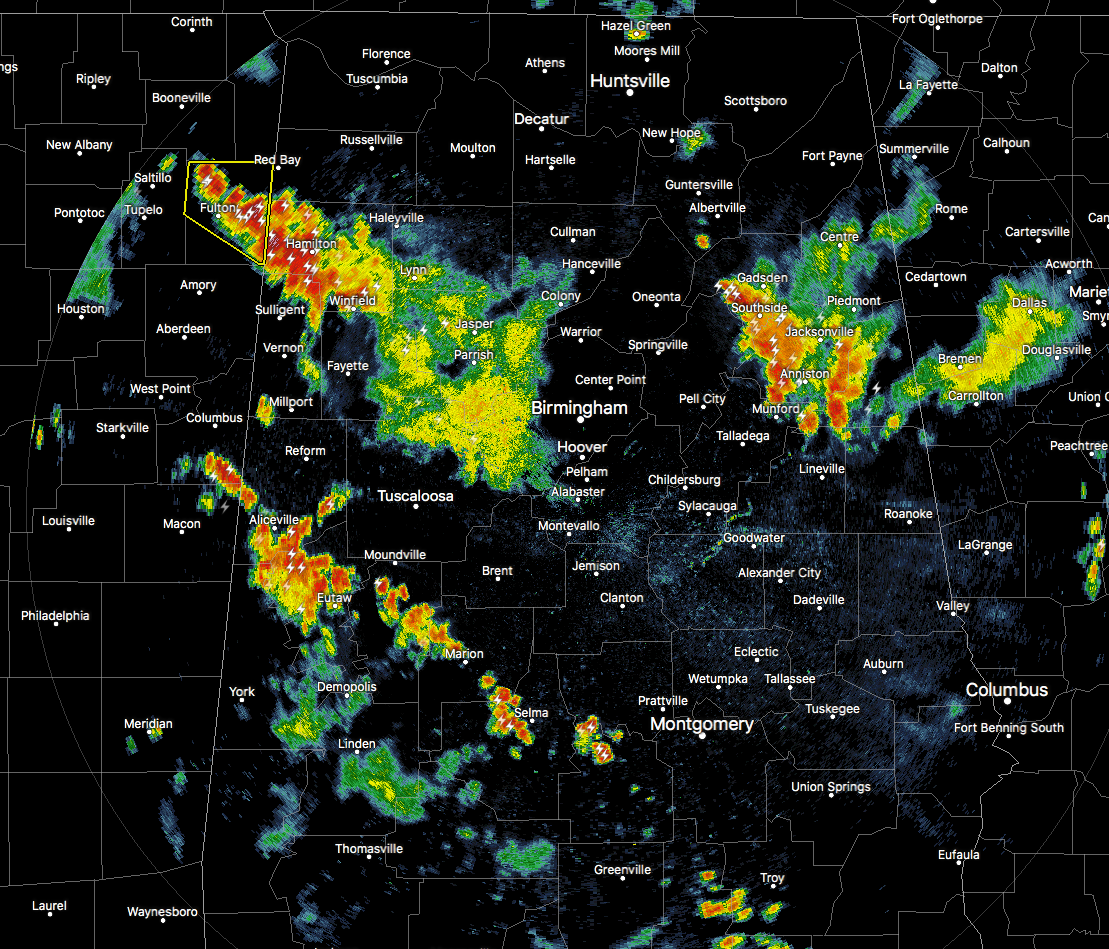
As of 7:00 PM, we continue to have storms moving to the west in the western parts of Central Alabama, but now we have strong storms moving westward in the eastern parts of the area as well. This new batch of storms over portions of Etowah, St. Clair, Calhoun, and Cleburne counties have a history of causing some wind damage.
Trees were reported downed just northwest of the Oxford Exchange in Calhoun County that caused some power outages. More damage in Calhoun County includes power lines down in Blue Mountain, trees down just east of Alexandria, and more trees downed just southeast of Hokes Bluff.
About 90 minutes ago, a damage report came in stating that a roof was blown off of a fertilizer shed near HWY 9 and CR 352 in the Coloma community (Cherokee County).
Along with these damage reports, we also have an Areal Flood Advisory issued for portions Calhoun, Cherokee, and Etowah counties until 9:00 PM. Over 1.50 inches of rain has fallen with this cluster of storms. These locations could see localized flooding for the next couple of hours: Piedmont, Hokes Bluff, Centre, Forney, Tennala, Ballplay, Slackland, Pleasant Gap, Moshat, Ball Flat, Eastern Weiss Lake, Coloma, Spring Garden, Knightens Crossroads and Reaves.
A new Areal Flood Advisory was issued for parts of Calhoun, Etowah, St. Clair, and Talladega counties until 9:15 PM. Heavy rainfall will affect Gadsden, Anniston, Oxford, Rainbow City, Attalla, Hokes Bluff, West End-Cobb Town, Cobb Town, Saks, Lincoln, Glencoe, Weaver, Ashville, Ragland, Munford, Ohatchee, Steele, Altoona, Hobson City and Walnut Grove. Over 2.40 inches of rain has fallen at Rainbow City (Etowah Co.) over the past 2 hours.
Strong storms in the western parts of the area are finally starting to exit the state and moving into eastern Mississippi. Very heavy rainfall and dangerous cloud-to-ground lightning is affecting locations in Lamar and Marion counties, including, Hamilton, Guin, Beaverton, Detroit, and Winfield.
Another broken line of storms is moving northward in the south and southwestern parts of the area stretching from Pickensville (Pickens Co.) to Marion (Perry Co.) to Selma (Dallas Co.) to Goshen (Pike Co.). The good news is that the storms in the northwestern parts of the area will be out of state when the line of storms make it to the I-20 corridor, but there may be interaction in a few hours with the storms in the northeastern parts of the area. We’ll have to watch to see if they will survive long enough for that to happen and if any storm intensification would occur.
Category: Alabama's Weather, ALL POSTS
About the Author (Author Profile)
Scott Martin is an operational meteorologist, professional graphic artist, musician, husband, and father. Not only is Scott a member of the National Weather Association, but he is also the Central Alabama Chapter of the NWA president. Scott is also the co-founder of Racecast Weather, which provides forecasts for many racing series across the USA. He also supplies forecasts for the BassMaster Elite Series events including the BassMaster Classic.Subscribe
If you enjoyed this article, subscribe to receive more just like it.


