

Midday Report: Marginal Risk Of Severe Storms For Parts Of North/Central Alabama
CONDITIONS ACROSS THE AREA AT 11:15 AM
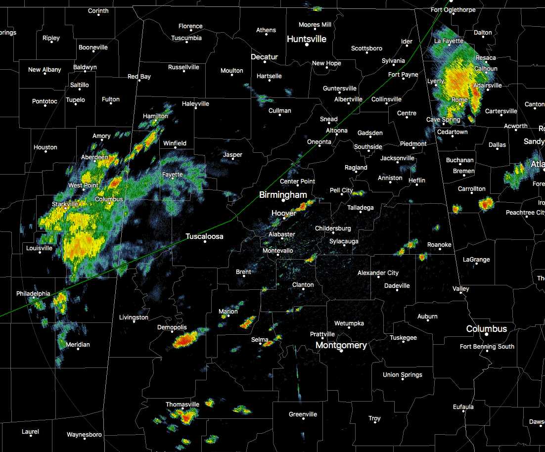
After having a good bit of shower and storm activity move across the northern portions of the state this morning, things have quieted down some. We do have a large batch of showers moving into the western parts of the area from Mississippi, along with several scattered showers over the southern half of Central Alabama. Where there is not rain, we have partly to mostly cloudy skies with temperatures in the mid-70s to the lower 90s. Birmingham was at 82 degrees, while the warm spots are Montgomery and Eufaula at 90 degrees with a good bit of sun. The cool spot is Cullman at 75 degrees due to rain-cooled air from earlier.
SOME STRONG TO SEVERE STORMS POSSIBLE LATER TODAY
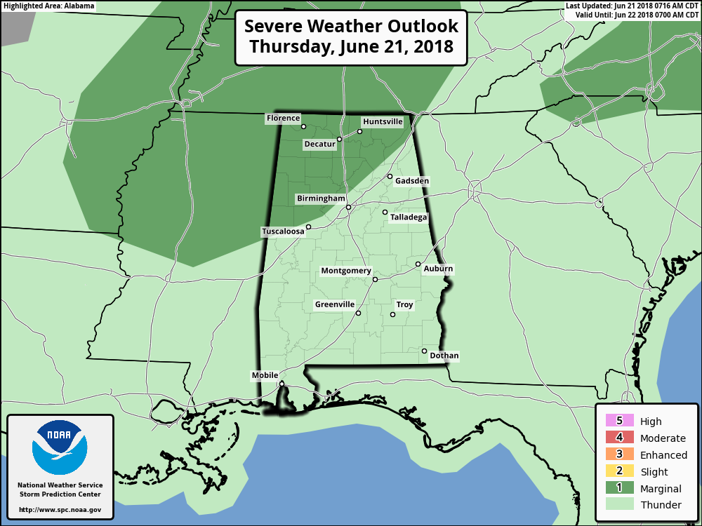
We’ll have a few breaks in the clouds at times today allowing for some sun, but the bad side is that any extra heating will add to the instability which could fire even more storms through the afternoon and into the early evening hours. Showers and storms will be likely through the afternoon and early evening hours, some of which north of a line from roughly Aliceville to Graysville to roughly Fort Payne could reach severe criteria with damaging winds up to 60 MPH. All storms today will have dangerous cloud-to-ground lightning and heavy rainfall, so some localized flooding issues could arise. Afternoon highs will make it up into the mid-80s to the mid-90s from northwest to southeast. Showers and storms will linger into the late night and through the overnight hours, with the higher rain chances north of a line from Demopolis to Alabaster to Anniston. Lows will be in the lower to mid-70s.
MORE STRONG TO SEVERE STORMS POSSIBLE ON FRIDAY
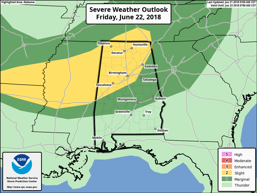
As the trough continues to move southward towards Central Alabama, a few impulses will travel through the trough. This will be the catalyst for more showers and thunderstorms mainly during the afternoon and evening hours. Instability values will be higher, along with precipitable water values, means that more stronger storms are possible. A Slight Risk for severe storms has been defined for all parts of the state north of a line from Cuba to Childersburg to Collinsville, while nearly the rest of Central Alabama has be defined in a Marginal Risk. Strong downdraft thunderstorm winds, very heavy rainfall, and dangerous cloud-to-ground lightning are the main threats. We may have a few severe thunderstorm and flash flood warnings issued during that time frame, so keep checking back on the blog for the latest on updates.
Rain chances will be higher north of a line from Demopolis to Clanton to Wedowee, but all of Central Alabama will have a decent chance. Afternoon highs will be up in the mid-80s to the lower 90s. Shower and thunderstorm chances diminish a little for the late night and overnight hours, but all of Central Alabama could still see a few out there. Lows will be in the lower to mid-70s.
AN UPDATE ON THE TROPICS
The North Atlantic, Caribbean Sea, and the Gulf of Mexico is calm at this time, and no new tropical cyclones are expected throughout the next 5 days.
ON THIS DAY IN WEATHER HISTORY
1919 – Seven heavy coach cars of a moving train were picked up and thrown from the tracks by tornado winds. A baggage car was set down thirty feet away from the rest of the train.
1987 – A tornado destroyed 57 mobile homes at the Chateam Estates trailer park northwest of Detroit, MI, killing one person and injuring six others. Total damage was estimated at 1.7 million dollars. Thunderstorms over Lower Michigan also drenched the Saginaw Valley with up to 4.5 inches of rain in less than six hours.
BEACH FORECAST CENTER
Get the latest weather and rip current forecasts for the beaches from Fort Morgan to Panama City on our Beach Forecast Center page. There, you can select the forecast of the region that you are interested in.
WE’RE HAVING A RECORD-BREAKING YEAR… ADVERTISE WITH US TODAY!
Don’t miss out! We have enjoyed over 10.9 MILLION page views on AlabamaWx.com since the start of 2018. We can customize a creative, flexible and affordable package that will suit your organization’s needs. Contact Bill Murray at (205) 687-0782.
E-FORECAST
Get the AlabamaWx Weather Blog’s Seven-Day Forecast delivered directly to your inbox by email twice daily. It is the most detailed weather forecast available in Central Alabama. Subscribe here… It’s free!
WEATHERBRAINS
Don’t forget you can listen to our weekly 90 minute netcast anytime on the web at WeatherBrains.com or on iTunes. This is the show all about weather featuring many familiar voices, including the meteorologists at ABC 33/40.
Category: Alabama's Weather, ALL POSTS
About the Author (Author Profile)
Scott Martin is an operational meteorologist, professional graphic artist, musician, husband, and father. Not only is Scott a member of the National Weather Association, but he is also the Central Alabama Chapter of the NWA president. Scott is also the co-founder of Racecast Weather, which provides forecasts for many racing series across the USA. He also supplies forecasts for the BassMaster Elite Series events including the BassMaster Classic.Subscribe
If you enjoyed this article, subscribe to receive more just like it.


