

An Update on the Alabama Weather Situation at 6 p.m.
The sun returned after morning convection across North and Central Alabama and heated the atmosphere.
Temperatures warmed to the middle 80s across Northwest Alabama and even to 90F or higher across West Central Alabama where morning convection was limited.
Dewpoints are extremely high, including 77F at Jasper and 75F at Tuscaloosa and at Muscle Shoals.
This has led to high instability values across the northern half of the state. Instability is lowest over Northeast Alabama, which is good, given that the best low-level shear extends from the Huntsville/Decatur areas eastward.
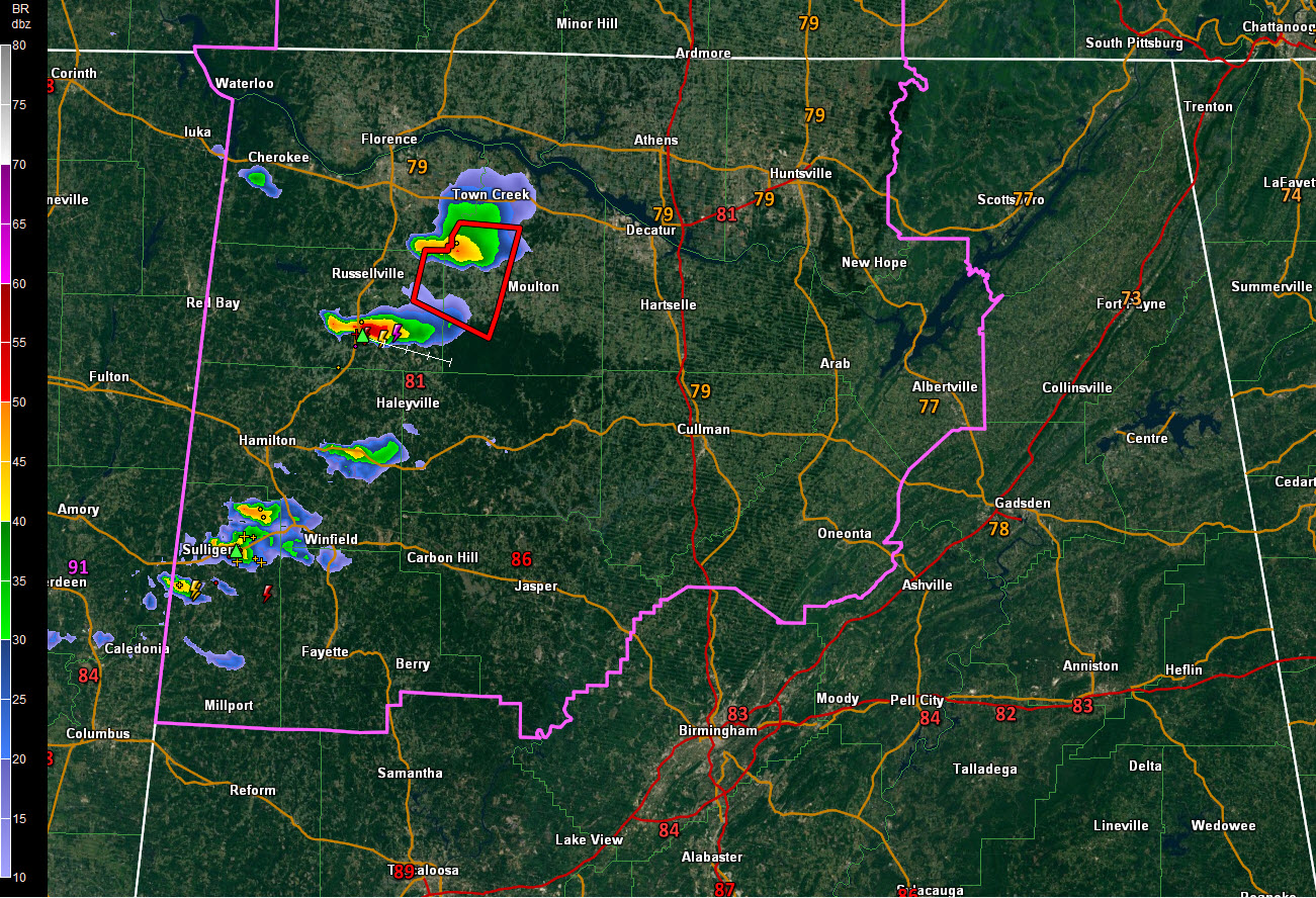
Storms are developing now across parts of Marion and Lamar Counties in West Alabama back into eastern Mississippi. The storm passing south of Guin in Marion County shows strong signs of producing hail. We will be watching these storms carefully. They are forming in an area which has 4,500-5,000 joules of CAPE to work with, which is very high.
The bulk shear is decent across Marion and Walker Counties and increases the further east you go across Cullman, Blount, and parts of Jefferson Counties.
The low-level helicity, key for tornadoes, is highest from Limestone, Madison, and Morgan Counties eastward across the Tennessee Valley. We will have to watch the Northwest Alabama storms as they start approaching Huntsville.
To the south, from Marion and Winston counties, through Walker, Cullman, Blount, northern Jefferson, and points, east, there is sufficient shear for an isolated tornado or two.
The storm that prompted the tornado warning for parts of Colbert, Frankin and Lawrence Counties has weakened a bit. But there is a very strong storm passing near Phil Campbell right now. It is intensifying, showing increasing signs of hail and will have to be watched.
The most recent complete run of the HRRR depicts the storms now forming, edging them southeastward across Winston, Cullman and Blount Counties before weakening them east of I-65. This is a believable solution given than instabilities are lowest there. We are watching the new run to see what it has to say.
Category: Alabama's Weather, ALL POSTS
About the Author (Author Profile)
Bill Murray is the President of The Weather Factory. He is the site's official weather historian and a weekend forecaster. He also anchors the site's severe weather coverage. Bill Murray is the proud holder of National Weather Association Digital Seal #0001 @wxhistorianSubscribe
If you enjoyed this article, subscribe to receive more just like it.


