

Midday Update: Hot & Waiting on Afternoon Storms
We are seeing a mainly sunny sky and it is a hot and humid day with temperatures generally in the upper 80s and lower 90s across Central Alabama this afternoon, while heat index values are over 100° and over 105° in some spots. We are watching the radar, but just after noon, we are seeing no storms develop, but it is only a matter of time before the radar gets very active.
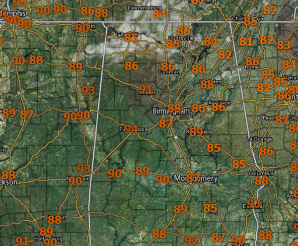
With the very high instability values in place across the state, any storms which can develop will pack a punch with tremendous amounts of lightning, intense tropical downpours, and carry the threat of gusty “microburst” winds as well as hail. These are those randomly scattered pulse thunderstorms we watch everyday dance across the Alabama landscape.
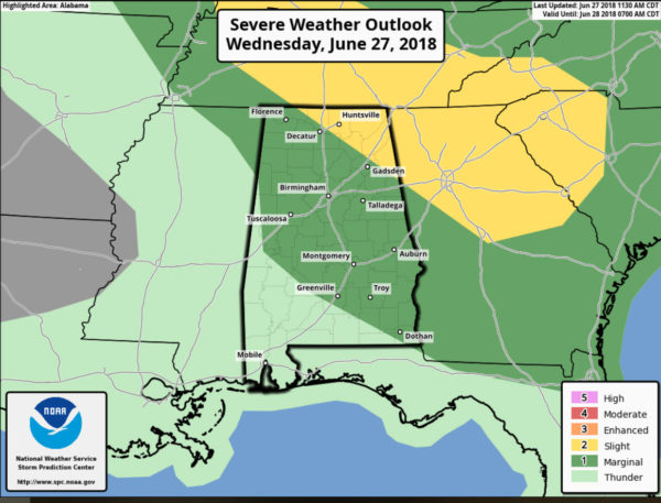
The SPC has a “slight risk” (level 2 out of 5) defined for the northeast portions of Alabama, with a “marginal risk” (level 1 out of 5) for most of the rest of the state as far south Demopolis, Greenville, and Dothan. In addition to the pulse thunderstorms, we are going to be watching for a developing MCS (Mesoscale Convective System) to our northwest and it should dive south and east this afternoon and evening and could enhance storms across these areas. The main threat will come from strong straight line winds, possibly enough in a few spots to knock down trees and power lines. The tornado threat is very low, but not zero. Stay weather aware later today and check the blog frequently.
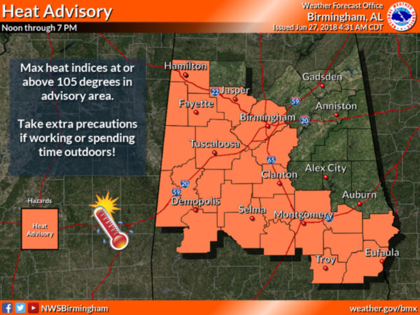
HEAT ADVISORY IN EFFECT: If the storms weren’t enough, it is yet another day with dangerous heat levels as portions of Central and West Alabama are again included in a Heat Advisory this afternoon as temperatures rise into the middle 90s this afternoon and heat indices could reach 105 degrees or above for a few hours. A heat advisory means the combination of hot temperatures and high humidity will combine to create a situation in which heat illnesses are possible. Drink plenty of fluids, stay in an air-conditioned room, stay out of the sun, and check up on relatives and check up on relatives and neighbors.
BRIGHT MOON-SATURN CONJUNCTION: Tonight, Saturn is “at opposition”–bigger, brighter, and closer to Earth than at any other time in 2018. To find the ringed planet, look south at midnight. You’ll see it shining like a golden star right beside the full “Strawberry Moon” in the constellation Sagittarius. This is also the best night of the year to see Saturn’s rings.
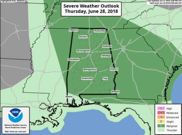
TOMORROW/FRIDAY: Expect hot, humid days with a mix of sun and clouds and the risk of scattered storms, mostly during the afternoon and evening hours. But, you always have the chance of a late night/early morning rogue storm. Afternoon highs will be in the 90-95 degree range and yes heat index values will likely be over 100° during the afternoons, and we are likely to see additional heat advisories issued across portions of Alabama this week. Of course, the models are hinting at the possibility of yet another MCS impacting the state late tomorrow and the SPC has outlined nearly the entire state of Alabama in a “marginal risk” for sever storms tomorrow and into tomorrow night.
GOODBYE JUNE, HELLO JULY: The overall weather pattern won’t change, so there will be little change in the day to day weather around here. Hot, humid days with the threat of a passing thunderstorm, mainly during the afternoon and evening hours. Daily storms will be random and scattered, and no way of knowing in advance exactly when and where they pop up. Of course, storms this time of year produce a lot of lightning, tropical downpours, and gusty winds. Highs will be at or just over 90 degrees on most days. Again, this is just what we almost always get in July around here.
TROPICAL OUTLOOK: A weak, non-tropical low pressure system located offshore of the the southeastern coast of North Carolina continues to produce a small area of disorganized cloudiness and showers. Environmental conditions are not expected to be conducive for development while this system moves northeastward away from the United States during the next couple of days. Formation chance through five days…low…near 0 percent.
THE ALABAMAWX BEACH FORECAST CENTER: Click here to see the AlabamaWx Beach Forecast Center page.
WORLD TEMPERATURE EXTREMES: Over the last 24 hours, the highest observation outside the U.S. was 122.4F at Joba, Oman. The lowest observation was -103.7F at Dome C, Antarctica.
CONTIGUOUS TEMPERATURE EXTREMES: The highest observation was 120F at Death Valley, CA. The lowest observation was 34F at Meacham, OR; Stanley, ID; and Yellowstone Lake, WY.
WEATHER ON THIS DATE IN 1988: The afternoon high of 107 degrees at Bismarck, ND, was a record for the month of June, and Pensacola, FL, equalled their June record with a reading of 101 degrees. Temperatures in the Great Lakes Region and the Ohio Valley dipped into the 40s.
Category: Alabama's Weather, ALL POSTS
About the Author (Author Profile)
Macon, Georgia Television Chief Meteorologist, Birmingham native, and long time Contributor on AlabamaWX. Stormchaser. I did not choose Weather, it chose Me. College Football Fanatic. @Ryan_StinnetSubscribe
If you enjoyed this article, subscribe to receive more just like it.


