

Numerous Storms Across North Central Alabama This Afternoon
Numerous thunderstorms have formed across North Central Alabama this afternoon to the south of an upper-level trough that is passing through the Tennessee Valley. They have plenty of instability to work with, as CAPE values are between 4-5,000 joules/kg. There is 205-25 knots of bulk shear, which isn’t much for extremely organized storms, but it is helping them hold together. There is well over 1,000 joules of downdraft CAPE, which means the strongest storms are candidates to produce damaging winds.
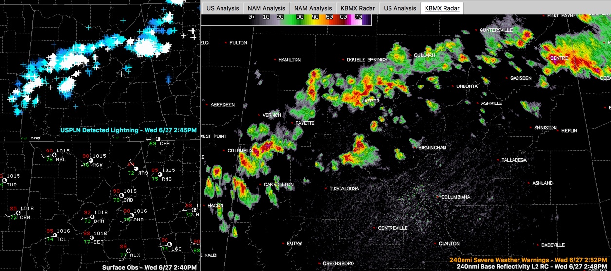
The storms extend from Cherokee in Northeast Alabama back to around Cullman then to between Jasper and Double Springs to Fayette to west of Carrollton in Pickens County.
The strongest storm is over Cherokee County and is centered near Centre. A severe thunderstorm warning was in effect until 2:45 p.m. but is being replaced with a significant weather alert. An areal flood advisory has been issued just within the past few minutes.
An isolated strong storm is over northeast Tuscaloosa County near Bankhead Lock and Dam. It is moving east at about 5-10 mph. It will affect northeastern Tuscaloosa, southern Walker, and southwestern Jefferson Counties.
This storm will move into southwestern parts of the Birmingham Metro and proceed eastward affecting areas from downtown through Hoover. Additional storms are forming near the Jefferson/Walker County line and will affect the rest of Jefferson County.
All of the storms are moving to the east at around 15-25 mph. All of them are capable of very heavy rain and dangerous lightning. The stronger ones could produce pea-sized hail and 40 mph wind gusts. The strongest could briefly become severe and produce damaging winds of 60 mph or greater.
Be inside when storms approach. If you can hear thunder, you are close enough to be struck by the lightning. When thunder roars, go indoors.
A severe thunderstorm watch could be issued if the storms continue to grow in intensity. Much of Northeast Alabama is in an SPC Slight Risk (level 2 of 5) severe weather risk and almost all of the rest of Central Alabama has a Marginal Risk, level 1 of 5, for the rest of the afternoon and evening.
Category: Alabama's Weather, ALL POSTS
About the Author (Author Profile)
Bill Murray is the President of The Weather Factory. He is the site's official weather historian and a weekend forecaster. He also anchors the site's severe weather coverage. Bill Murray is the proud holder of National Weather Association Digital Seal #0001 @wxhistorianSubscribe
If you enjoyed this article, subscribe to receive more just like it.


