

Midday Update: Watching Strong Storms Heading South
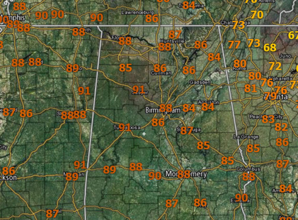
It is another hot and humid day with temperatures generally in the upper 80s and lower 90s late this morning across North/Central Alabama. Heat index values will be over 100° this afternoon and likely over 105° in some spots.
We will be watching the radar for those random scattered afternoon storms. With the very high instability values in place across the state, any storms which can develop will pack a punch with tremendous amounts of lightning, intense tropical downpours, and carry the threat of gusty “microburst” winds as well as hail. These are those randomly scattered pulse thunderstorms we watch everyday dance across the Alabama landscape.
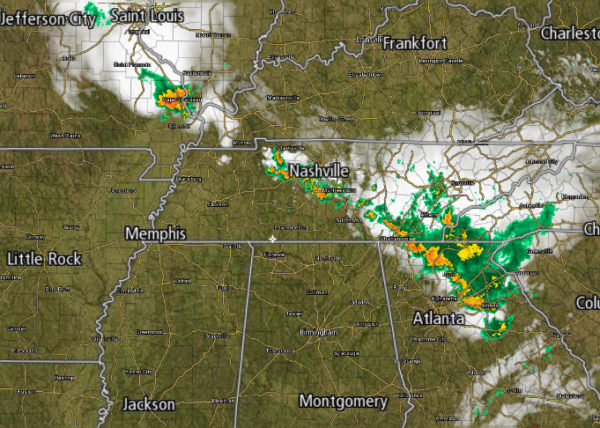
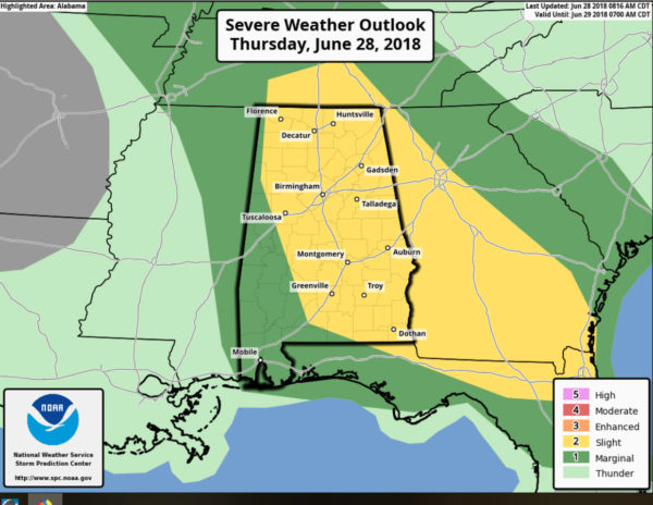
Additionally, SPC has much of the state highlighted in a “slight risk” (level 2 out of 5) for most of of the state today and tonight. In addition to the pulse thunderstorms, we are going to be watching an area of thunderstorms to our north, and likely a developing MCS (Mesoscale Convective System) as it should dive south and east this afternoon and evening which could enhance storms across the area. The main threat will come from strong straight line winds, possibly enough in a few spots to knock down trees and power lines. The tornado threat is very low, but not zero. Stay weather aware later today and check the blog for updates.
The SPC has issued a mesoscale discussion and a severe weather watch is likely forthcoming for portions of North Alabama. A severe threat is expected to continue across parts of the Tennessee Valley and southern Appalachian Mountains late this morning. Wind damage and isolated large hail will be the primary threats. A new weather watch will likely be needed across the region.
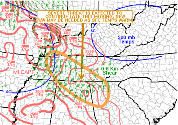
DISCUSSION…The latest surface analysis shows a quasistationary front located from western Kentucky extending southeastward into northern Georgia. Along and south of the boundary, moderate instability is analyzed by the RAP with MLCAPE values estimated in the 1500 to 3000 J/kg range. A line of training strong to severe thunderstorms is ongoing along the instability gradient from middle Tennessee into northern Georgia. The WSR-88D VWP near the AL-TN stateline shows 0-6 km shear near 40 kt. This combined with steepening low-level lapse rates late this morning will be favorable for severe storms capable of producing wind damage and isolated large hail. A new weather watch will be issued shortly.
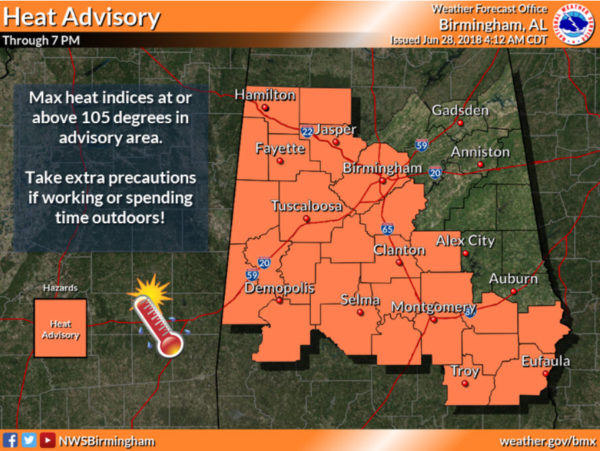
HEAT ADVISORY IN EFFECT: Yet another day with dangerous heat levels as portions of Central and West Alabama are again included in a Heat Advisory this afternoon as temperatures rise into the middle 90s this afternoon and heat indices could reach 105 degrees or above for a few hours. A heat advisory means the combination of hot temperatures and high humidity will combine to create a situation in which heat illnesses are possible. Drink plenty of fluids, stay in an air-conditioned room, stay out of the sun, and check up on relatives and check up on relatives and neighbors.
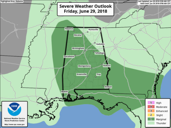
FOR FRIDAY: Expect a hot, humid day with a mix of sun and clouds and the risk of scattered storms, mostly during the afternoon and evening hours. But, you always have the chance of a late night/early morning rogue storm. Afternoon highs will be in the 90-95 degree range and yes heat index values will likely be over 100° during the afternoon, and we are likely to see another heat advisory issued across portions of Alabama. Of course, the models are hinting at the possibility of a MCS impacting the state and the SPC has outlined nearly the entire state of Alabama in a “marginal risk” for severe storms tomorrow.
THE ALABAMA WEEKEND: Both days a mix of sun and clouds with “scattered, mostly afternoon and evening showers and storms”. The storms will be random and there is no way of knowing exactly when and where they form in advance. Rain chances will be in the 40-50% range, so better than average for this time of year, but still not complete washout. Highs will be in the low 90s for most locations.
HELLO JULY: We will continue with a persistence forecast through next week. No signs of any big upper high that will put a lid on convection, so each day we will have lots of sun during the morning hours, and scattered strong storms during the afternoon and evening. Highs will be in the 88-91 degree range on most days.
TROPICAL OUTLOOK: All remains very quiet across the Atlantic basin, and tropical storm formation is not expected through next week. Expect very routine summer weather on the Gulf Coast with lots of sun and just a brief passing storm from time to time.
THE ALABAMAWX BEACH FORECAST CENTER: Click here to see the AlabamaWx Beach Forecast Center page.
WORLD TEMPERATURE EXTREMES: Over the last 24 hours, the highest observation outside the U.S. was 123.1F at Joba, Oman. The lowest observation was -104.4F at Dome C, Antarctica.
CONTIGUOUS TEMPERATURE EXTREMES: The highest observation was 117F at Death Valley, CA. The lowest observation was 34F at Bryce Canyon, UT.
WEATHER ON THIS DATE IN 1923: A massive tornado hit Sandusky, OH, then swept across Lake Erie to strike the town of Lorain. The tornado killed 86 persons and caused twelve million dollars damage. The tornado outbreak that day was the worst of record for the state of Ohio up til that time.
Category: Alabama's Weather, ALL POSTS
About the Author (Author Profile)
Macon, Georgia Television Chief Meteorologist, Birmingham native, and long time Contributor on AlabamaWX. Stormchaser. I did not choose Weather, it chose Me. College Football Fanatic. @Ryan_StinnetSubscribe
If you enjoyed this article, subscribe to receive more just like it.


