

Severe Thunderstorm Watch Posted For Parts of North/Central Alabama Until 7:00 PM
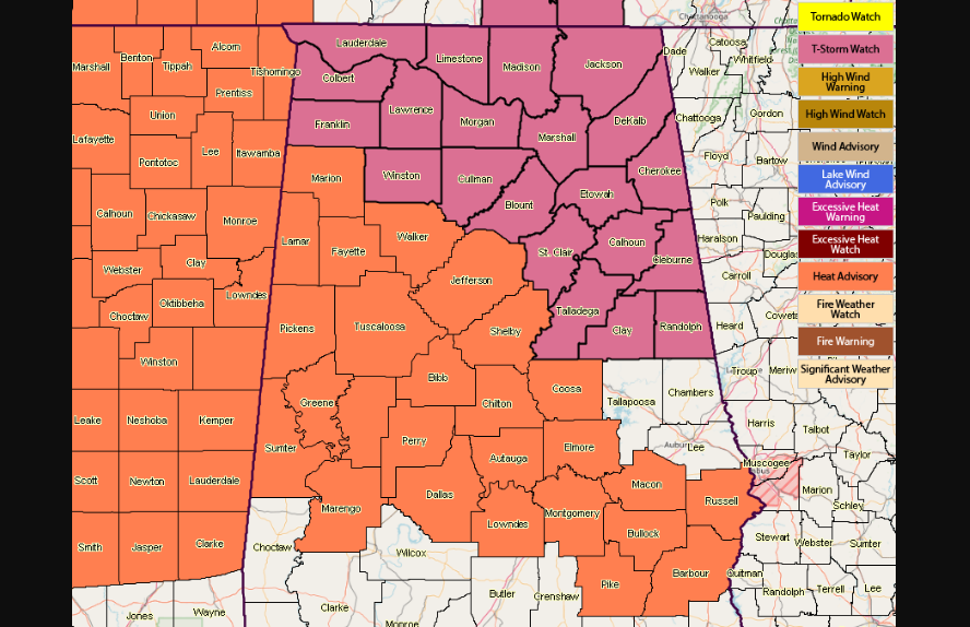
The Storm Prediction Center, in conjunction with NWS Huntsville and NWS Birmingham, has issues a Severe Thunderstorm Watch for parts of the North/Central Alabama area until 7:00 PM this evening.
North Alabama counties in the watch: Colbert, Cullman, DeKalb, Franklin, Jackson, Lauderdale, Lawrence, Limestone, Madison, Marshall, Morgan.
Central Alabama counties in the watch: Blount, Calhoun, Cherokee, Clay, Cleburne, Etowah, Randolph, St. Clair, Talladega, Winston.
SUMMARY: Thunderstorms will continue to develop and spread southeastward across the watch area this afternoon. The strongest cells will be capable of locally damaging wind gusts through the afternoon.
A Severe Thunderstorm Watch means conditions are favorable for severe thunderstorms in and close to the watch area. Persons in these areas should be on the lookout for threatening weather conditions and listen for later statements and possible warnings. Severe thunderstorms can and occasionally do produce tornadoes.
Category: Alabama's Weather, ALL POSTS
About the Author (Author Profile)
Scott Martin is an operational meteorologist, professional graphic artist, musician, husband, and father. Not only is Scott a member of the National Weather Association, but he is also the Central Alabama Chapter of the NWA president. Scott is also the co-founder of Racecast Weather, which provides forecasts for many racing series across the USA. He also supplies forecasts for the BassMaster Elite Series events including the BassMaster Classic.Subscribe
If you enjoyed this article, subscribe to receive more just like it.


