

Flash Flood Watch Issued For Parts of North Alabama Until 7:00 PM
…FLASH FLOOD WATCH IN EFFECT UNTIL 7 PM CDT THIS EVENING…
THE NATIONAL WEATHER SERVICE IN HUNTSVILLE HAS ISSUED A
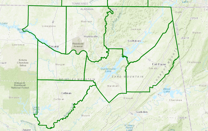
* FLASH FLOOD WATCH FOR PORTIONS OF ALABAMA AND SOUTHERN MIDDLE
TENNESSEE, INCLUDING THE FOLLOWING AREAS, IN ALABAMA, CULLMAN,
DEKALB, JACKSON, LIMESTONE, MADISON, MARSHALL, AND MORGAN. IN
SOUTHERN MIDDLE TENNESSEE, FRANKLIN TN, LINCOLN, AND MOORE.
* UNTIL 7 PM CDT THIS EVENING
* RAINFALL OF 2 TO 4 INCHES IS LIKELY IN SOME AREAS THIS
AFTERNOON. MUCH OF THIS RAINFALL WILL FALL IN A VERY SHORT
PERIOD OF TIME.
* LOW WATER CROSSINGS AND POOR DRAINAGE AREAS WILL LIKELY BE THE
LOCATIONS WITH THE HIGHEST RISK OF FLASH FLOODING. THIS COULD
IMPACT THE RUSH HOUR LATER THIS AFTERNOON AND EARLY THIS
EVENING.
PRECAUTIONARY/PREPAREDNESS ACTIONS…
A FLASH FLOOD WATCH MEANS THAT CONDITIONS MAY DEVELOP THAT LEAD
TO FLASH FLOODING. FLASH FLOODING IS A VERY DANGEROUS SITUATION.
YOU SHOULD MONITOR LATER FORECASTS AND BE PREPARED TO TAKE ACTION
SHOULD FLASH FLOOD WARNINGS BE ISSUED.
Category: Alabama's Weather, ALL POSTS
About the Author (Author Profile)
Scott Martin is an operational meteorologist, professional graphic artist, musician, husband, and father. Not only is Scott a member of the National Weather Association, but he is also the Central Alabama Chapter of the NWA president. Scott is also the co-founder of Racecast Weather, which provides forecasts for many racing series across the USA. He also supplies forecasts for the BassMaster Elite Series events including the BassMaster Classic.Subscribe
If you enjoyed this article, subscribe to receive more just like it.


