

Plenty Of Storms To Go Around As We Near 7:00 PM

As of 6:45 PM, we have some pretty hefty thunderstorms out there across North and Central Alabama that are putting down heavy amounts of rain in a short amount of time, along with some gusty winds and very dangerous cloud-to-ground lightning.
Looking at radar, one of the larger batch of strong storms is lined up along I-59/20 between Brookwood and Tuscaloosa, down to the southwest through Boligee and Epes. This cluster of storm is producing intense rainfall, especially north of the interstate and numerous cloud-to-ground lightning strikes. Go ahead and be ready to move indoors if you are in Gordo to Aliceville to Geiger and to Emelle.
Another large batch of storms is stretching across parts of Blount, Cullman, Jefferson, and Walker counties that is also producing very heavy rainfall and intense cloud-to-ground lightning. I was caught in this storm about 45 minutes ago when it passed through Gardendale and it only took about 3-5 minutes for the roadways to start ponding, especially US-31, Main Street, and Fieldstown Road. If you are in Sipsey, Jasper, Cordova, Parrish, and Oakman, be ready for very heavy rain, plenty of lightning, and a few brief strong wind gusts.
And up in North Alabama, we have a broken line of stronger storms stretching from the Tennessee state line just northeast of New Market to Madison to Hartselle to Falkville. Same deal as the rest… very heavy rainfall, brief gusty winds, and plenty of intense lightning. Be ready to move indoors if you are in Decatur, Athens, Harvest, and Hazel Green.
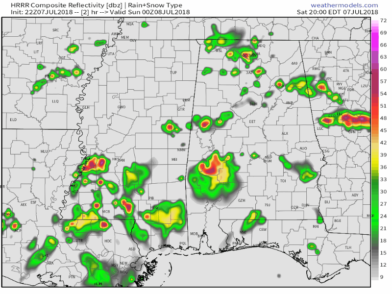
This is the latest run of the HRRR Simulated Radar from 7:00 PM tonight to 2:00 AM Sunday. It shows that activity will start to calm down and diminish throughout the evening and into the late night hours, and staying mainly quiet through the pre-dawn hours, even though I wouldn’t be surprised if we have a stray shower or two move in from Georgia before sunrise.
Category: Alabama's Weather, ALL POSTS
About the Author (Author Profile)
Scott Martin is an operational meteorologist, professional graphic artist, musician, husband, and father. Not only is Scott a member of the National Weather Association, but he is also the Central Alabama Chapter of the NWA president. Scott is also the co-founder of Racecast Weather, which provides forecasts for many racing series across the USA. He also supplies forecasts for the BassMaster Elite Series events including the BassMaster Classic.Subscribe
If you enjoyed this article, subscribe to receive more just like it.


