

Hot At This Point; Strong to Severe Storms Tonight
The big headlines for today’s weather will be the heat to start off with, then followed by a severe threat later this evening and into the overnight hours.
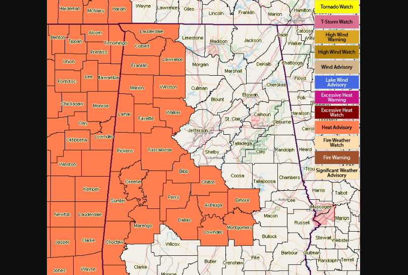
A Heat Advisory for several North Alabama counties will go into effect at noon and last until 6:00 PM. Those counties are Colbert, Franklin, Lauderdale, and Lawrence. Several Central Alabama counties will go under a Heat Advisory from noon until 7:00 PM tonight. Those counties are Autauga, Bibb, Chilton, Dallas, Elmore, Fayette, Greene, Hale, Lamar, Lowndes, Marengo, Marion, Montgomery, Perry, Pickens, Sumter, Tuscaloosa, Walker, and Winston.
With high temperatures forecast to be in the lower to middle 90s this afternoon and early evening will send heat index values up into the 104 to 107 degrees range. Please be sure to drink plenty of fluids and stay as cool as possible if having to be outside for extended periods of time.
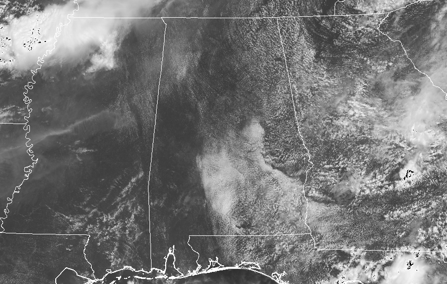
So as of 11:35 AM, radar is free from any shower or storm activity, and with skies remaining mostly clear across much of the area, current temperatures are already up into the lower to mid-80s across Central Alabama. The warm spot is Tuscaloosa at 86 degrees, while the cool spot is Alexander City which has a little cloud cover, keeping the temperature down at 78 degrees at this point.
For this afternoon and into the early evening hours, skies will remain mostly clear to partly cloudy with only a slight chance for isolated to scattered showers and thunderstorms. Rain chances will be around or less than 25% for any one location. Afternoon highs will be in the lower to mid-90s.
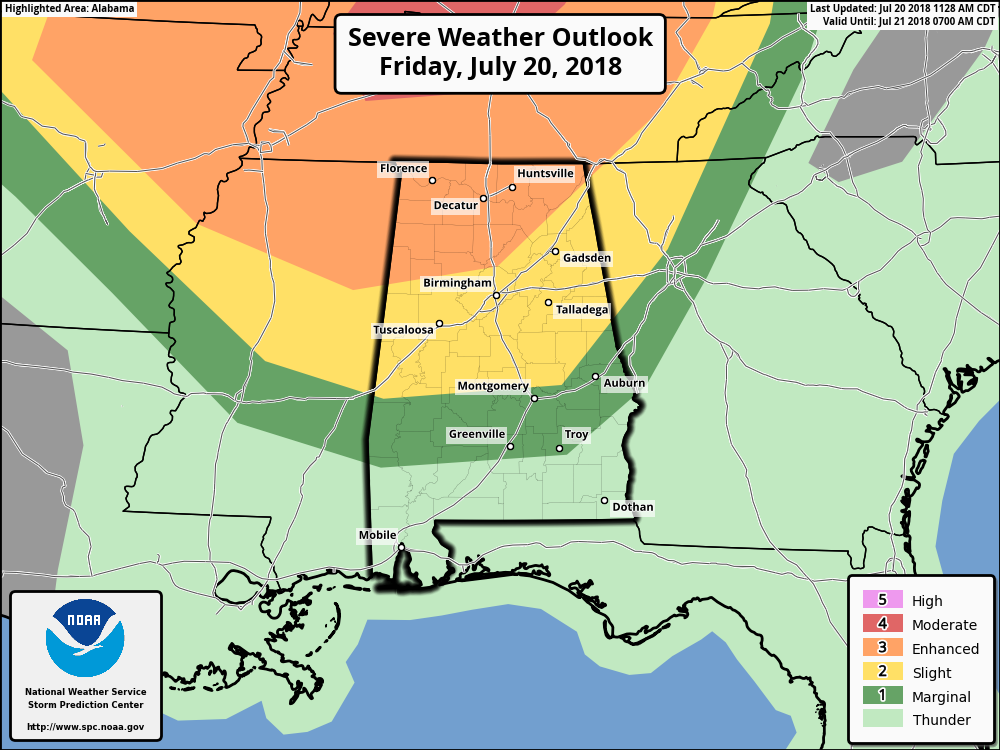
As you can see by the above image, the Storm Prediction Center has several risk levels of severe storms for the evening through the late night and early morning hours. An Enhanced Risk is defined for locations north of a line from Fayette to Warrior to Ider. A Slight Risk is defined for locations north of a line from just south of Cuba to Tallassee to Roanoke up to the enhanced risk. Nearly the rest of Central Alabama is defined in a Marginal Risk with the exception of the southern half of Pike County and nearly all of Barbour County.
The main threats from the storms that will be moving from the northwest to the southeast will be from damaging thunderstorm wind gusts of 60-70 MPH, along with a small threat of a couple of isolated tornadoes and some large hail. The greater chance of widespread damaging wind gusts will be in the Enhanced Risk locations, with a lesser chance of scattered damaging wind gusts in the Slight Risk locations, and a much lesser chance of isolated damaging wind gusts in the Marginal Risk locations.
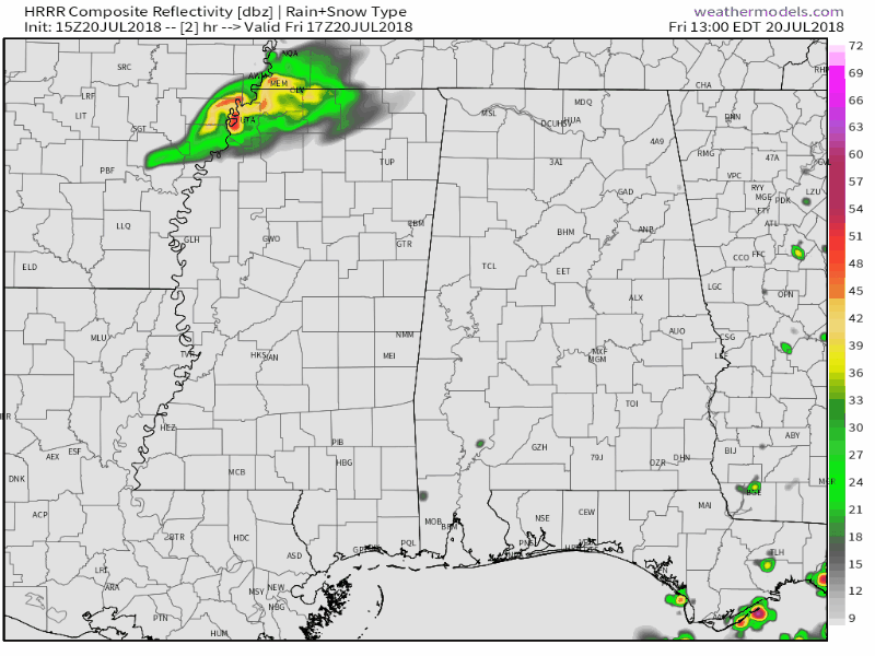
The main window for stronger to severe storms will be from 6:00 PM tonight until at least 6:00 AM Saturday morning. The above animation is for noon today until 4:00 AM Saturday from the latest run of the HRRR showing that there will be several clusters moving through North and Central Alabama.
With much of the area staying dry through the day, this is allowing the surface instability to climb high ranging from 1500 J/kg in the east to at or just over 4500 J/kg in the west. We are also seeing Significant Tornado Parameters off of the HRRR nearing 5-6 in the northwest corner of the state, with values of 2-4 stretching down as far south as Greene and Hale counties. We are even seeing STP values ranging from 2-3.5 in portions of Jefferson, Tuscaloosa, and Walker counties, including the cities of Birmingham, Tuscaloosa, and Jasper.
The best thing to do is to go ahead and have your emergency plans and supplies ready to go just in case your location goes under a warning later tonight or during the overnight hours. I recommend that you either get the MyWarn app or the WDT Weather Radio app for your smart phones. Have those smart phones charged up and make sure you have fresh batteries in your NOAA Weather Radios and flashlights.
We’ll continue to have updates throughout the day and I’ll be up with you throughout the late night and overnight hours with severe coverage on the blog.
Category: Alabama's Weather, ALL POSTS
About the Author (Author Profile)
Scott Martin is an operational meteorologist, professional graphic artist, musician, husband, and father. Not only is Scott a member of the National Weather Association, but he is also the Central Alabama Chapter of the NWA president. Scott is also the co-founder of Racecast Weather, which provides forecasts for many racing series across the USA. He also supplies forecasts for the BassMaster Elite Series events including the BassMaster Classic.Subscribe
If you enjoyed this article, subscribe to receive more just like it.


