

Plenty Of Sun & Really Hot: It’s Your Midday Nowcast For Central Alabama
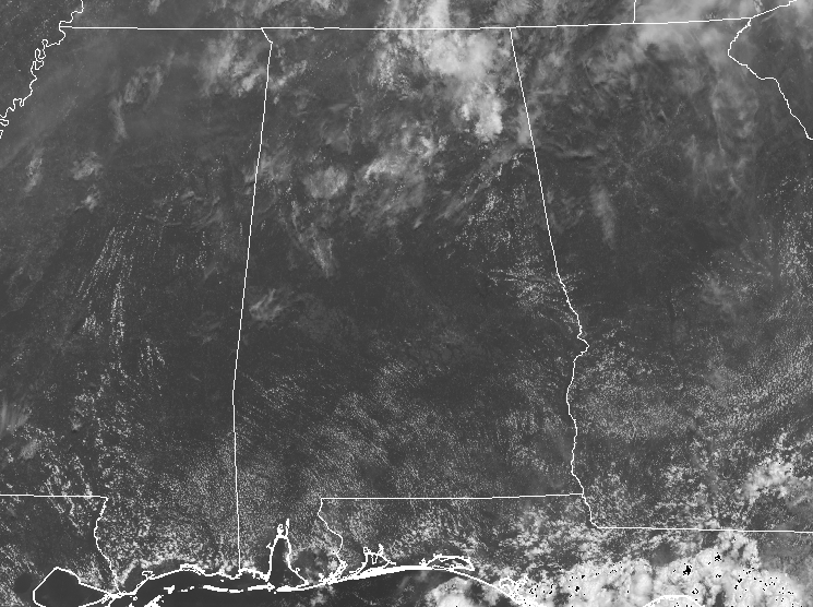
A QUICK CHECK ON OUR WEATHER AT 12:00 PM: We have a good supply of sunshine across Central Alabama with only a few clouds filtering out the sun at times for some locations. Up in the northeastern parts of the state, we do have some heavier cloud cover with a few showers falling over parts of Jackson County. All of Central Alabama is dry and hot with temperatures in the mid-80s to the lower 90s. Birmingham and Jasper are both tied at 91 degrees as the warm spots.
WEATHER FOR THE REST OF YOUR WEDNESDAY: While most of Central Alabama will have a good bit of sunshine with the skies being a little hazy, while there will be a very small chance of isolated showers or storms in the extreme southern parts of the area (south of a line from Demopolis to Montgomery to Phenix City). Most locations will be in the lower to mid-90s, while one or two may touch the upper 90s for a little bit. For tonight and into the overnight hours, any showers and storms in the south will diminish soon after we lose the sunlight and the heating of the day, but some patchy fog may develop in those locations that do receive rainfall today. The remainder of Central Alabama will have mostly clear skies. Lows will be in the lower to mid-70s.
LOOK BEFORE YOU LOCK: Never leave children, disabled or elderly adults, or pets in parked vehicles. Studies have shown that the temperature inside a parked vehicle can rapidly rise to a dangerous level for children, pets, and even adults. Leaving the windows slightly open does not significantly decrease the heating rate. The effects can be more severe on children because their bodies have not developed the ability to efficiently regulate internal temperature. Heat-related deaths are preventable, so look before you lock.
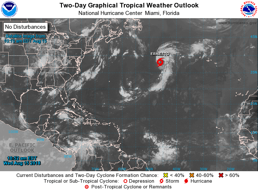
A LOOK AT THE TROPICS: As of 10:00 AM today, the center of Subtropical Storm Ernesto was located near latitude 38.1 North, longitude 46.0 West. The storm is moving toward the north near 8 mph (13 km/h). A turn toward the north-northeast is expected later today, and a faster northeastward motion is expected by late Thursday and should continue through early Saturday. Maximum sustained winds have increased to near 40 MPH with higher gusts. Some additional strengthening is possible during the next 24 hours. The system is expected to become a post-tropical cyclone Thursday night or early Friday. The rest of the Atlantic Basin is quiet.
ON THIS DAY IN WEATHER HISTORY: 1967 – The Sundance fire in northern Idaho was started by lightning. Winds of 50 MPH carried firebrands as much as ten miles in advance to ignite new fires, and as a result, the forest fire spread twenty miles across the Selkirk Mountains in just twelve hours, burning 56,000 acres. The heat of the fire produced whirlwinds of flame with winds up to 300 MPH which flung giant trees about like matchsticks.
BEACH FORECAST CENTER: Looks like we’ll have some sun with a good bit of clouds and a good chance of showers and thunderstorms along the Gulf Coast today through the weekend, with much better conditions for the start of the work week. Get the latest weather and rip current forecasts for the beaches from Fort Morgan to Panama City on our Beach Forecast Center page. There, you can select the forecast of the region that you are interested in.
WE’RE HAVING A RECORD-BREAKING YEAR… ADVERTISE WITH US TODAY!: Don’t miss out! We have enjoyed over 13.2 MILLION page views on AlabamaWx.com since the start of 2018. We can customize a creative, flexible and affordable package that will suit your organization’s needs. Contact Bill Murray at (205) 687-0782.
E-FORECAST: Get the AlabamaWx Weather Blog’s Seven-Day Forecast delivered directly to your inbox by email twice daily. It is the most detailed weather forecast available in Central Alabama. Subscribe here… It’s free!
WEATHERBRAINS: Don’t forget you can listen to our weekly 90 minute netcast anytime on the web at WeatherBrains.com or on iTunes. This is the show all about weather featuring many familiar voices, including the meteorologists at ABC 33/40.
Category: Alabama's Weather, ALL POSTS
About the Author (Author Profile)
Scott Martin is an operational meteorologist, professional graphic artist, musician, husband, and father. Not only is Scott a member of the National Weather Association, but he is also the Central Alabama Chapter of the NWA president. Scott is also the co-founder of Racecast Weather, which provides forecasts for many racing series across the USA. He also supplies forecasts for the BassMaster Elite Series events including the BassMaster Classic.Subscribe
If you enjoyed this article, subscribe to receive more just like it.


