

Sun And Scattered Storms
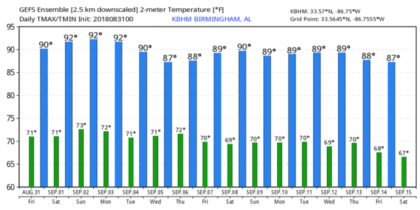
MUGGY DAYS; SCATTERED STORMS: Moist, unstable air will continue to cover Alabama today, and this afternoon showers and storms should fire up in random, scattered places. Models have trended a little drier; odds of any one spot getting wet this afternoon are in the 30/40 percent range. The high will be between 87 and 90 degrees with a mix of sun and clouds.
THE ALABAMA WEEKEND: Tomorrow is the first of meteorological fall, but we all know it doesn’t magically turn cool in Alabama. In fact, some of the hottest weather on record has happened during the first week of September. The high tomorrow will be in the upper 80s tomorrow, and close to 90 on Sunday, so it will certainly feel like summer. Look for a partly sunny sky both days, and we will deal with afternoon showers and storms again in scattered spots. They should thin out Sunday as the air becomes more stable thanks to a strengthening upper ridge.
FOOTBALL WEATHER: For high school games tonight, the weather will be warm and humid with the risk of a shower or thunderstorm, mainly during the first half. Some games could very well be dealing with a lightning delay; temperatures will be mostly in the upper 70s.
Tomorrow, Auburn takes on Washington in Atlanta in Mercedes Benz Stadium (2:30p CT kickoff). Outside the domed stadium, afternoon temperatures will be in the 87-90 degree range with the risk of a shower or thunderstorm.
Then, tomorow evening, Alabama will take on Louisville in Orlando (7:00p CT kickoff). The weather will be humid, and a shower or thunderstorm is possible during the game, mainly during the first half. Kickoff temperature in the low 80s, falling into the upper 70s by the final whistle.
NEXT WEEK: With the ridge holding, we expect partly sunny days, fair nights, and only widely scattered, mostly afternoon and evening showers or thunderstorms for much of the week. Highs will remain in the 87-90 degree range, which is near average for the first part of September in our state. See the Weather Xtreme video for maps, graphics, and more details.
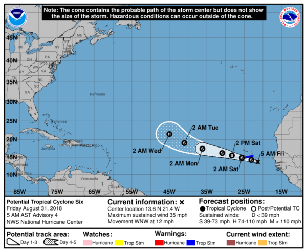
TROPICS: “Potential tropical cyclone six” in the far eastern Atlantic is expected to become Tropical Storm Florence later today or tonight. It will move west/northwest, and NHC expects it to become a hurricane by the middle of next week. As the system gains latitude, that increases the chance that this will recurve over open water with no threat to North America, but that is not totally carved in stone.
A tropical wave is near Hispaniola; this feature will move toward the eastern Gulf of Mexico in coming days, but harsh upper winds should prevent this from developing; NHC gives it only a 10 percent chance of development over the next five days.
BEACH FORECAST: Click here to see the AlabamaWx Beach Forecast Center page.
WEATHER BRAINS: Don’t forget you can listen to our weekly 90 minute netcast anytime on the web, or on iTunes. This is the show all about weather featuring many familiar voices, including our meteorologists here at ABC 33/40.
CONNECT: You can find me on all of the major social networks…
Facebook
Twitter
Instagram
Pinterest
Snapchat: spannwx
I have a weather program this morning at Cherokee Bend Elementary in Mountain Brook… look for the next Weather Xtreme video here by 4:00 this afternoon. Enjoy the day!
Category: Alabama's Weather, ALL POSTS, Weather Xtreme Videos
About the Author (Author Profile)
James Spann is one of the most recognized and trusted television meteorologists in the industry. He holds the AMS CCM designation and television seals from the AMS and NWA. He is a past winner of the Broadcast Meteorologist of the Year from both professional organizations.Subscribe
If you enjoyed this article, subscribe to receive more just like it.


