

It’s Mid-September & It Still Feels Like Mid-July At Midday
CONDITIONS ACROSS CENTRAL ALABAMA AT NOON
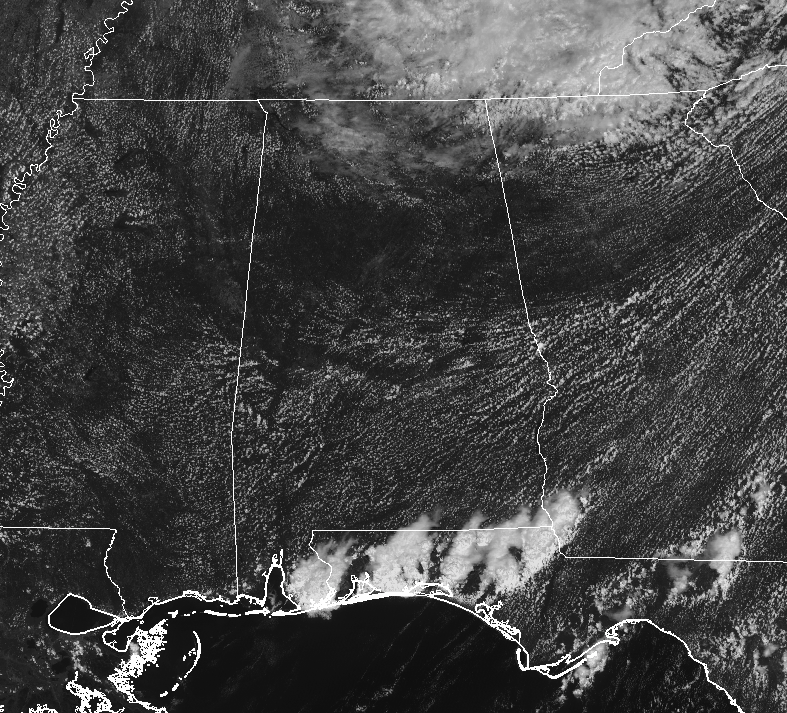
Skies across Central Alabama as we have hit the lunch-time hour on the final Monday of summer are mostly clear allowing plenty of sunshine to reach the surface and offering very little in relief from the heat. And speaking of the heat, temperatures are already up into the mid-80s to the lower 90s. Montgomery is currently the hot spot at 93 degrees, while Birmingham was sitting at 88 degrees.
WEATHER FOR THE REST OF TODAY
We’ll continue to have mostly clear and hot conditions across much of Central Alabama through the remainder of the afternoon and early evening hours, but a few isolated showers may be possible over the extreme southern parts of the area, along with the extreme northeast corner of the area. Rain chances in those areas will be around 20%. Afternoon highs will be up in the lower to mid-90s, with the possibility of one or two spots hitting the upper 90s. For tonight, clouds will decrease and any shower activity will diminish shortly after sunset. Skies will become mainly clear and overnight lows will be in the mid-60s to the lower 70s.
THE TROPICS ARE FINALLY CALMING DOWN FOR A LITTLE BIT
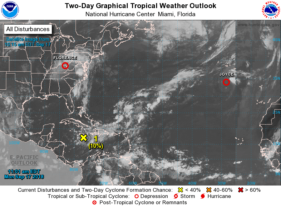
While Florence continues to bring torrential rains to the Carolinas and up into Virginia, the rest of the Atlantic Basin has calmed down a good bit. The remnants of Isaac are still lingering around close to Jamaica, redevelopment is unlikely within the next 5 days. Joyce is a confused depression at this point, but will make a curve back to the southwest within the next couple of days and will become subtropical by Wednesday.
Florence continues to hang on as a depression for the time being as it begins to accelerate to the north and northeast today, before curving more eastward over the southern parts of New England on Tuesday. While losing tropical characteristics and transitioning into an extratropical low, some intensification is expected while moving off over the northern Atlantic Ocean.
Parts of southern North Carolina have seen rainfall totals well over 30 inches, to go along with portions of northern South Carolina and western North Carolina who have seen up to 20 inches. An elevated risk of flooding and landslides can be expected in the next couple of days as rainfall will slowly begin to taper off this week.
STORM TOTALS FROM THE IMPACT OF FLORENCE ON THE ATLANTIC COAST
These are preliminary rainfall (in inches) and wind observations associated with Florence from 2:00 pm ET on Thursday (09/13/18) through this morning at 10:00 am ET.
TOP 10 NC RAINFALL TOTALS
- 35.93 …. ELIZABETHTOWN 6.2 NW
- 33.89 …. SWANSBORO 1.4 N
- 30.38 …. GURGANUS .5 N
- 29.62 …. HOFMANN FOREST RAWS
- 29.52 …. HAMPSTEAD 4.1 WNW
- 27.44 …. SUNNY POINT RAWS
- 27.40 …. NATURE CONSERVANCY RAWS
- 26.98 …. OAK ISLAND .9 ENE
- 26.58 …. WILMINGTON 7.3 NE
- 25.91 …. WHITEVILLE 6.1 NW
TOP 10 SC RAINFALL TOTALS
- 23.63 …. LORIS 2.9 WSW
- 23.18 …. LORIS 1.4 ENE
- 22.58 …. CHERAW WATER PLANT
- 21.18 …. CAROLINA SAND HILLS RAWS
- 19.94 …. CHESTERFIELD (MAIN ST)
- 19.56 …. MARION 3 E RAWS
- 18.38 …. DILLON 3.8 NW
- 15.75 …. PAWLEYS ISLAND 2.6 N
- 15.68 …. BENNETTSVILLE 1.2 SE
- 15.41 …. MYRTLE BEACH 8.4 NNW
TOP 10 VA RAINFALL TOTALS
- 10.56 …. MEADOWS OF DAN 4.5 SW
- 9.86 …. WILLIS 2.7 SE
- 9.54 …. COPPER HILL 6.2 S
- 8.84 …. CALLAWAY 4 WSW
- 8.65 …. STUART
- 8.33 …. CHECK
- 6.60 …. FERRUM
- 6.05 …. HORSE PASTURE 2 E
- 5.86 …. WOOLWINE
- 5.65 …. LAUREL FORK
TOP 10 PEAK WIND GUSTS (IN MPH)
- BUOY 30 SE NEW RIVER INLET …. 112
- FORT MACON …. 105
- WILMINGTON INT’L ARPT (KILM) …. 105
- CAPE LOOKOUT …. 97
- CEDAR ISLAND 1 N …. 89
- CHERRY POINT ASOS …. 87
- JACKSONVILLE ASOS …. 86
- FRISCO WOODS …. 80
- OCRACOKE …. 80
- HARKERS ISLAND …. 77
BEACH FORECAST CENTER
Get the latest weather and rip current forecasts for the beaches from Fort Morgan to Panama City on our Beach Forecast Center page. There, you can select the forecast of the region that you are interested in.
CONNECT ON SOCIAL MEDIA
You can find the AlabamaWx Weather Blog on the major social media networks:
Facebook
Twitter
WE’RE HAVING A RECORD-BREAKING YEAR… ADVERTISE WITH US TODAY!
Don’t miss out! We have enjoyed over 14.7 million page views on AlabamaWx.com since the start of 2018. We can customize a creative, flexible and affordable package that will suit your organization’s needs. Contact Bill Murray at (205) 687-0782.
E-FORECAST
Get the Alabama Wx Weather Blog’s Seven-Day Forecast delivered directly to your inbox by email twice daily. It is the most detailed weather forecast available in Central Alabama. Subscribe here… It’s free!
WEATHERBRAINS:
Don’t forget you can listen to our weekly 90 minute netcast anytime on the web at WeatherBrains.com or on iTunes, Stitcher, or Spotify. This is the show all about weather featuring many familiar voices, including the meteorologists at ABC 33/40.
ON THIS DAY IN WEATHER HISTORY
1989 – Hurricane Hugo hit the Virgin Islands, producing wind gusts to 97 mph at Saint Croix. Hurricane Hugo passed directly over the island of Saint Croix causing complete devastation and essentially cutting off the island from communications. A storm surge of five to seven feet occurred at Saint Croix. The only rain gauge left operating, at Caneel Bay, indicated 9.40 inches in 24 hours. Hurricane Hugo claimed the lives of three persons at Saint Croix and caused more than 500 million dollars damage. A ship, Nightcap, in the harbor of Culebra, measured wind gusts as high as 170 mph. A cold front brought high winds to the Great Basin and the Rocky Mountain Region, and thunderstorms along the cold front produced wind gusts to 66 mph at Yellowstone Park WY.
Category: Alabama's Weather, ALL POSTS
About the Author (Author Profile)
Scott Martin is an operational meteorologist, professional graphic artist, musician, husband, and father. Not only is Scott a member of the National Weather Association, but he is also the Central Alabama Chapter of the NWA president. Scott is also the co-founder of Racecast Weather, which provides forecasts for many racing series across the USA. He also supplies forecasts for the BassMaster Elite Series events including the BassMaster Classic.Subscribe
If you enjoyed this article, subscribe to receive more just like it.


