

Most Areas Hot and Dry for the First Full Day of Fall; Rain Chances Going Up Though
Fall officially arrived last night at 8:54 p.m. CDT. But you can’t tell it by the thermometer. Highs across Central Alabama on Saturday included 91F at Calera, 92F at Anniston, 93F at Tuscaloosa and the winner, 95F at Birmingham.
BAMA SHOWER: A heavy shower developed over Tuscaloosa a couple of hours before gametime Saturday and it cooled things off prior to kickoff of the game with Texas A&M. But the sun came out pretty quickly and it was a hot and steamy afternoon for the SEC Clash. The weather at Auburn was warm and humid under the lights. UAB may have had the best weather. They had a bye this week.
WISTFULLY WISHING FOR SUCH SHOWER: rain showers and a few storms did become pretty numerous during the afternoon and evening hours yesterday over northwestern Alabama. That activity was close to a stationary front that will be hanging around all week. Does that mean better rain chances? Let’s see.
FOR YOUR SUNDAY: A patch of drier air covers much of the southeastern two-thirds of the state today. This means that most of the area will remain dry and warm, with highs near 90F. But over Northwest Alabama, in an area of deeper moisture, close to a stationary surface front, showers and some thunder will be fairly numerous again. The clouds and showers will hold temperatures back into the lower and middle 80s.
WET WEATHER EXPANDS INTO THE NEW WORK WEEK: Our upper flow will become consistently southwesterly and our low-level flow will become southerly by tomorrow. This means showers and some thunder will remain in the forecast across much of the area through Wednesday and perhaps into Thursday. High temperatures will be limited to the lower and middle 80s, which will be a relief in light of our recent heat.
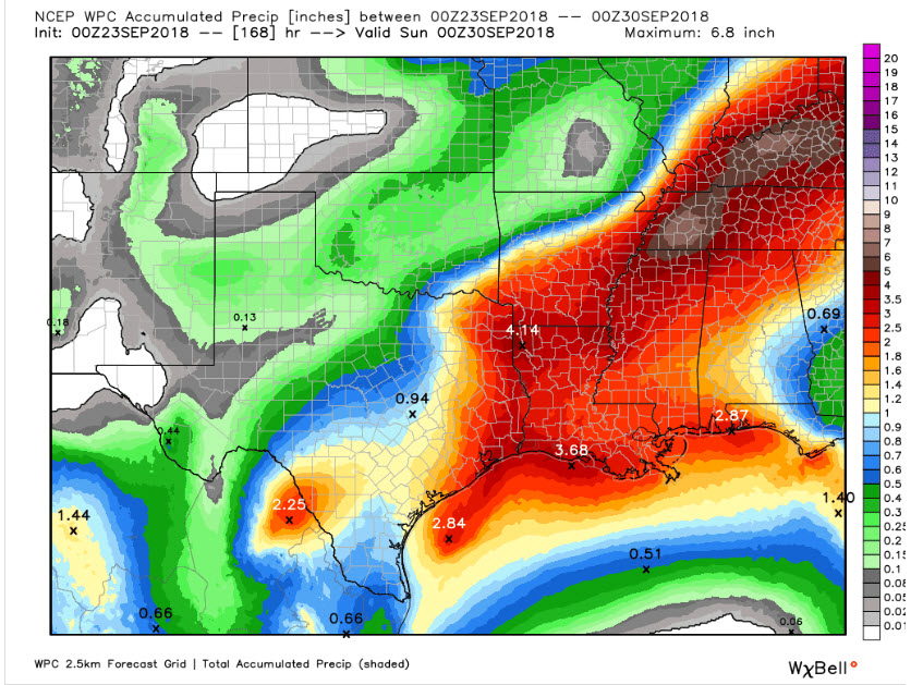
WELCOME RAIN: The northern half of the state is abnormally dry with some full-out drought conditions across areas of Northwest and North Alabama. Most areas in Central Alabama need rain as well, so any rain that does fall this week will be very welcome. While some very heavy rainfall amounts are expected to our northwest over parts of Tennessee and northern Mississippi, Alabama amounts will range from around 3 inches near the Shoals to between 1-2 inches in the I-59 Corridor to around an inch in the I-85 Corridor.
WORKING FOR THE WEEKEND: High pressure will begin to take control of our weather again by the end of the week. Rain chances will drop. Now if the Euro is right, we could see highs in the lower 80s through the weekend, since it forecasts that the front will eventually push through. But the GFS keeps it at bay and warms up back up by the weekend. Highs return to the upper 80s.
WHERE’S OUR COOL DOWN: With an advertised pattern change evolving, we thought that we would see some cooler temperatures in general. The Euro does predict a general cooling trend over the next two weeks, with highs trending back to the 80F range for highs with lows in the 60s the first week of October. That makes sense.
TROPICS: The tropical Atlantic has become quite active. But no major threats across the basin for the short term. Tropical depression 11 will likely dissipate today about 350 miles east of the Windward Islands. Tropical Storm Kirk formed on Saturday. It may threaten the Lesser Antilles by Thursday or Friday as a strong tropical storm. A disturbance in the Atlantic between Bermuda and the Azores may develop into a tropical cyclone over the next few days. It would be no threat to the United States. Another disturbance south of Bermuda will perhaps develop as it moves toward the southeastern Coast of the U.S. (around the Carolinas). But upper-level conditions will not favor additional development.
GULF COAST WEATHER: Rain chances will be in the forecast for the week ahead along the beautiful beaches of Alabama and Northwest Florida. Expect 3-5 hours of sun each day, with scattered to numerous showers and storms. Highs will be in the upper 80s, lows in the middle 70s. Seas will be running 1-2 feet. The rip current threat will be low to moderate.
Click here to see the Beach Forecast Center page.
WEATHERBRAINS: This week, the panel will entertain old friend Jay Prater from Wichita. Check out the show at www.WeatherBrains.com. You can also subscribe on iTunes. You can watch the show live at live.bigbrainsmedia.com You will be able to see the show on the James Spann 24×7 weather channel on cable or directly over the air on the dot 2 feed.
ON THIS DATE IN 1975: Hurricane Eloise makes landfall during the morning hours between Fort Walton Beach and Panama City, Florida. Eloise was the first hurricane to make landfall in that area in this century. A storm surge of 12-16 feet accompanied the storm with a high water mark of 18.2 feet at Dune Allen Beach, Florida. Winds reached 125 mph sustained with gusts to 155 mph. 21 deaths were reported in the United States. Remarkably, none of them occurred in Florida. They occurred in the Northeast because of flooding and traffic accidents Follow my weather history tweets on Twitter. I am @wxhistorian at Twitter.com.
Category: Alabama's Weather, ALL POSTS
About the Author (Author Profile)
Bill Murray is the President of The Weather Factory. He is the site's official weather historian and a weekend forecaster. He also anchors the site's severe weather coverage. Bill Murray is the proud holder of National Weather Association Digital Seal #0001 @wxhistorianSubscribe
If you enjoyed this article, subscribe to receive more just like it.


