

Still Wet Today, Then Dry Through Much Of Next Week
MORE RAIN: Here are some of the rain totals yesterday from team of ABC 33/40 Skywatchers….
Bessemer 4.30″
McCalla 4.26″
RocK Creek 4.25″
Hueytown 4.07″
Black Creek 2.26″
Jemison 1.76″
Mountain Brook 1.44″
Millport 0.85″
Coker 0.82″
Weaver 0.71″
Jacksonville 0.64″
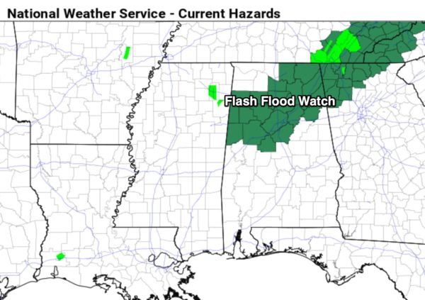
Wet weather continues across Alabama today with the approach of a deep upper trough and surface cold front; a flash flood watch remains in effect for parts of North and Central Alabama…
We will forecast periods of rain today along with potential for some thunder; additional rain amounts of around one inch are likely. Temperatures won’t get out of the 70s because of clouds and rain. The rain will end tonight as drier air begins to drop southward.
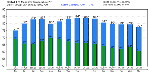
TOMORROW AND THE WEEKEND: Most of Alabama will be dry with mostly sunny warm days and fair pleasant nights. Any showers should be confined to the southern counties of the state, and even there they should be few and far between. Look for highs in the low 80s tomorrow, and mid 80s over the weekend. Morning lows will be well down in the 60s, and many of the cooler spots across North Alabama will enjoy temperatures in the 50s.
FOOTBALL WEATHER: For the high school games tomorrow night, the sky will be mostly fair with temperatures falling through the 70s.
Alabama will host Louisiana-Lafayette Saturday morning at Bryant-Denny Stadium (11:00 a.m. CT kickoff)… the sky will be mostly partly to mostly sunny. Temperatures will rise from near 80 at kickoff, into the mid 80s by the final whistle.
Auburn will host Southern Mississippi Saturday afternoon at Jordan-Hare Stadium (3:00 p.m. CT kickoff); the sky will be partly to mostly sunny with just a small risk of a shower. Temperatures will fall from near 84 at kickoff, into the upper 70s by the final whistle.
UAB will host Charlotte at Legion Field in Birmingham Saturday evening (6:00 p.m. CT kickoff). Temperatures will fall from near 80 degrees at kickoff, into the upper 70s by the second half. The sky will be mostly fair; should be a great evening for football.
NEXT WEEK: An upper ridge begins to rebuild; for now much of the week looks warm and dry with highs in the 80s. See the Weather Xtreme video for maps, graphics, and more details.
TROPICS: TropicaL Storm Kirk, with sustained winds of 50 mph, will move through the Lesser Antilles today. Then, it is expected to dissipate over the Caribbean due to strong shear. A large circulation over the North Atlantic could be designed Subtropical Storm Leslie again today, but it is far from land. The rest of the Atlantic basin is quiet.

We are also watching Hurricane Rosa in the eastern Pacific… moisture from that storm will bring the threat of heavy rain to parts of Arizona this weekend.
BEACH FORECAST: Click here to see the AlabamaWx Beach Forecast Center page.
WEATHER BRAINS: Don’t forget you can listen to our weekly 90 minute netcast anytime on the web, or on iTunes. This is the show all about weather featuring many familiar voices, including our meteorologists here at ABC 33/40.
CONNECT: You can find me on all of the major social networks…
Facebook
Twitter
Instagram
Pinterest
Snapchat: spannwx
Look for the next Weather Xtreme video here by 4:00 this afternoon… enjoy the day!
Category: Alabama's Weather, ALL POSTS, Weather Xtreme Videos
About the Author (Author Profile)
James Spann is one of the most recognized and trusted television meteorologists in the industry. He holds the AMS CCM designation and television seals from the AMS and NWA. He is a past winner of the Broadcast Meteorologist of the Year from both professional organizations.Subscribe
If you enjoyed this article, subscribe to receive more just like it.


