

Plane Enroute to Tropical Depression; A Look at the Latest Model Output
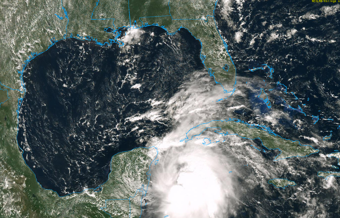
Here is a late morning update on Tropical Depression Number 14, located in the western Caribbean.
The system continues to look better organized on satellite his morning, despite the fact that it is still being impinged upon by 20-30 knots of wind shear. This might normally keep such a system from organizing, but very warm water over the western Caribbean that extends down to a large depth and some upper-level outflow that is helping maintain storms near the center.
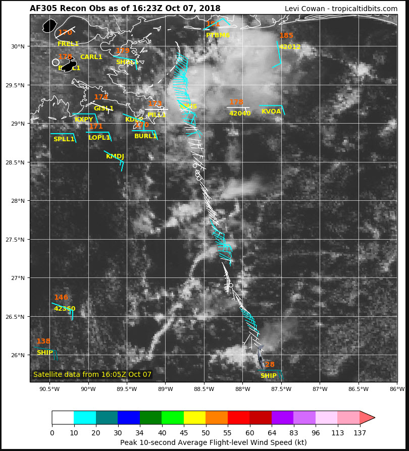
An Air Force Reserve Hurricane Hunter Plane is now en route to the storm from its Home Base at Keesler AFB in Biloxi, Mississippi. We will have data from the plane in the next couple of hours. They may well find that the system is already a tropical storm. If so, it will be named Michael.
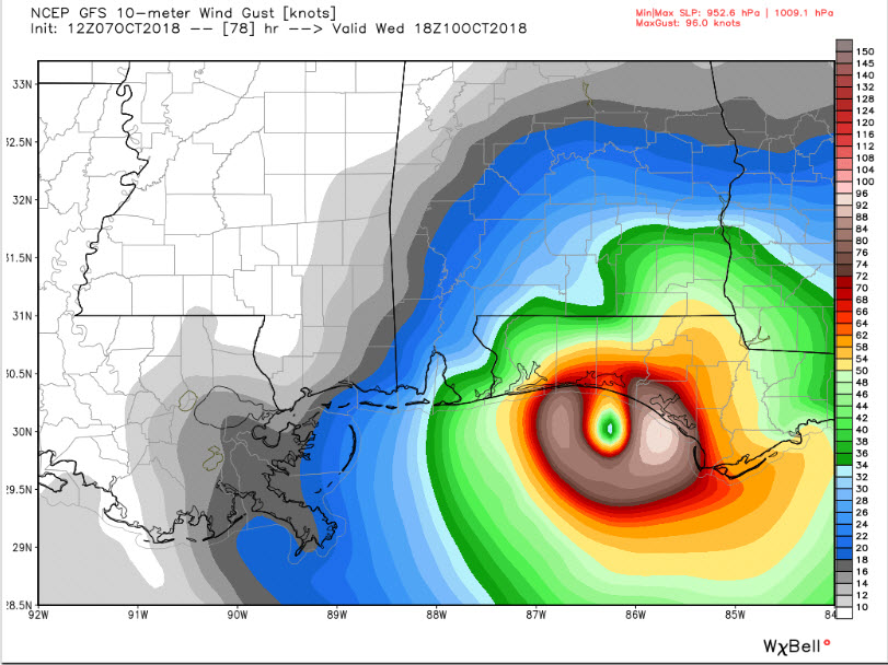
12z GFS valid at 18 Wednesday showing 110-115 mph gusts east of the center
The morning runs of the GFS and 12 km NAM are out to at least 84 hours, which is enough to cover the period to landfall. The GFS is a tiny bit slower than the previous run and a tiny bit to the east, but still showing a landfall around noon on Wednesday near Destin with a central pressure of 953 mb and sustained winds of 95 mph with gusts to 115 mph.
The NAM introduces an interesting wrinkle, slowing the storm Wednesday afternoon and turning it sharply to the right over Apalachee Bay and keeping it offshore through the end of its 84-hour run. It is slightly weaker.
It will be interesting to see the determinisitic run of the European and the ensembles of the GFS and Euro, which have been showing a great deal of difference in forward speed prior to landfall and eventual location of the storm.
Other models from late last night include:
FV3-GFS: Much faster with landfall near Pensacola early Wednesday morning around 3 a.m. as a 954 mb hurricane. This is the new version of the GFS that is still experimental. It shows the system moving up into South Central and East Central Alabama just southeast of Birmingham Wednesday afternoon. This would, of course, have a much bigger impact on Alabama if it were to happen.
HWRF: 945 millibar hurricane near Fort Walton around 4 a.m. Wednesday.
NAVGEM: 976 millibars near Pensacola around noon Wednesday.
EURO: 964 millibars near Panama City around midnight Wednesday night.
So, lots of uncertainty in the specific track so it is too early to nail down impacts. But high wind and rain will impact areas along and near the coast stretching inland along the track. The strongest winds will be on the eastern side of the center and its track. Heavy rains of 5-8 inches will fall along and east of the track. It is too early to tell what surge values will look like, but a landfall of a category two hurricane with top winds of 95-100 mph could produce storm surge of 5-10 feet along the coast with higher wave action. Eloise was a marginal category 3 hurricane in 1975 and produced 12-16 feet of surge between Destin and Panama City. Some of that may have been wave action of top of the surge. Opal in 1995 produced 3-9 feet of surge with higher wave action when it made landfall near Pensacola as a weakening storm.
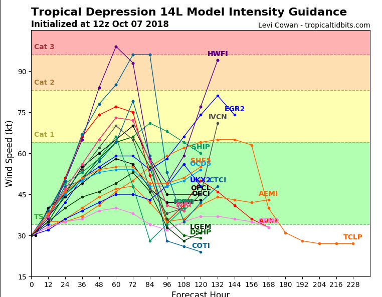
Some of the intensity guidance is showing the storm achieving category three intensity now, with several showing category two.
We will have frequent updates as we work to clarify the forecast and grasp the impacts.
About the Author (Author Profile)
Bill Murray is the President of The Weather Factory. He is the site's official weather historian and a weekend forecaster. He also anchors the site's severe weather coverage. Bill Murray is the proud holder of National Weather Association Digital Seal #0001 @wxhistorianSubscribe
If you enjoyed this article, subscribe to receive more just like it.


