

Great Race Weather, Unsettled Monday/Tuesday, Beautiful Wednesday-Friday, More Rain for the Weekend
It’s hard to believe that it was just a week ago that we were tracking Tropical Depression Fourteen in the western Caribbean, wondering whether it would be a memorable storm. We feared that might be the case, with lots of warm water and lessened shear ahead of it as it moved toward the northern Gulf Coast, but no one could envision that it would become the third strongest landfalling U.S. hurricane by central pressure.
TROPICS: The tropics are quieting down again as we are writing off Leslie this morning after 72 advisories and 22 days of tracking. Leslie moved across Portugal and into Spain yesterday and this morning and is finally dissipating. The tropical Atlantic looks like it will be quiet for the foreseeable future.
SPECIAL WEATHERBRAINS: We will be talking with all sorts of folks that either covered or were involved in Hurricane Michael on Monday evening’s WeatherBrains show. Be sure to tune in to the three-hour marathon.
SUNDAY SHOWERS: A few showers moved across Northwest Alabama Saturday evening, leaving about a tenth of an inch of rain in some areas, including Muscle Shoals. Those showers remained north of I-20 for the most part overnight and are moving out this morning. They are associated with the remnants of Pacific Hurricane Sergio, that moved across Baja and into the southwestern United States late last week. Showers will be possible today for areas north of I-59. But most of Central Alabama will be high and dry with highs in the 82-87F range, including…
TALLADEGA: Great weather for today’s big race at the World’s Fastest Superspeedway. Partly cloudy skies, light winds, and highs in the lower 80s will greet fans.
NEW WORK WEEK: Monday will feature more showers to start the day for areas north of I-59. This activity will sag southeastward during the day ahead of an approaching cold front. rainfall amounts will be generally light, around one-quarter of an inch. Highs will range from the middle 70s over Northwest Alabama to the lower 80s through I-20 and middle 80s over South Central Alabama.
FRONT VISITS ON TUESDAY: The cold front will waver across Central Alabama on Tuesday, with a few showers still possible, but mainly over South Central and South Alabama. Highs on Tuesday will be limited to the 70s.
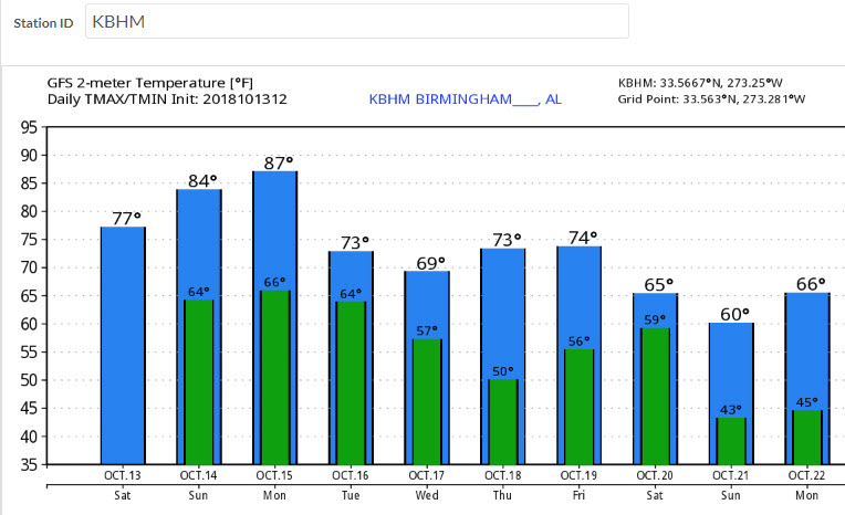
NICE MIDWEEK WEATHER: Wednesday will be cooler, with highs struggling to get out of the 60s. A few folks will wake up to 40s on Wednesday, a lot will on Thursday. Highs Thursday and Friday will be in the lower and middle 70s. Perfect October weather. Here are temperatures for the week ahead off the GFS:
FRIDAY INTO THE WEEKEND: Friday will be a transition day with increasing moisture across the area but the rain should hold off until Saturday. Expect a good chance of a rain and some thunder on Saturday as another cold front moves into the area. This will set the stage for a cool and dry period across Alabama for that following week.
VOODOO TERRITORY: Looking out to the end of the period on October 29th, we find a trough over the East, which sets the stage for more cool and dry weather over Alabama and the Southeast.
GULF COAST WEATHER: Beautiful weather today with rain in the forecast for Monday through Tuesday. Wednesday will feature improving conditions with great weather for Thursday and most of Friday. Rain wil return Friday into the weekend. Highs will be generally in teh 80s. Lows in the 60s and 70s. Click here to see the Beach Forecast Center page.
ON THIS DATE IN 1966: Iowa was struck by devastating late-season tornado outbreak. A total of 12 tornadoes touched down, including an F4 that devastated a large part of Belmond Iowa. It was the day of the homecoming parade in the town, but fortunately, the threatening skies had caused the crowds to break up before the twister’s arrival. 6 people died in this tornado. 75 of the 112 businesses in the town were destroyed. Damage totaled $12 million.
Category: Alabama's Weather, ALL POSTS
About the Author (Author Profile)
Bill Murray is the President of The Weather Factory. He is the site's official weather historian and a weekend forecaster. He also anchors the site's severe weather coverage. Bill Murray is the proud holder of National Weather Association Digital Seal #0001 @wxhistorianSubscribe
If you enjoyed this article, subscribe to receive more just like it.


