

Beautiful Day Today; Rain And Storms By Thursday
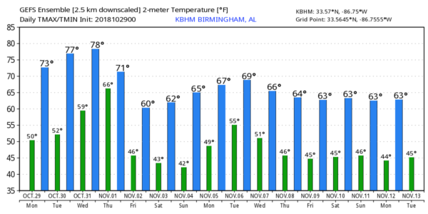
SUNSHINE IN FULL SUPPLY: A new supply of cool, dry air has moved into Alabama overnight, and that will set the stage for a delightful autumn day across Alabama with sunshine in full supply along with a high in the low 70s. Tomorrow will be sunny as well with a warmer afternoon; most communities will reach the mid to upper 70s.
HALLOWEEN: For Wednesday, the sky will be partly sunny, and the day will be mild with a high in the upper 70s. Moisture levels will begin to rise, however, and we will mention some risk of widely scattered showers during the afternoon and evening hours. For the trick or treaters, the rain won’t be widespread, and we don’t expect any thunder. But, a shower can’t be ruled out, especially along and west of I-65 through 9:00 p.m.
RAIN AND STRONG STORMS: A dynamic weather system will bring widespread rain and thunderstorms to Alabama late Wednesday night and Thursday. For now, it looks like the core window for this will come from 12 midnight Wednesday night until 3:00 p.m. Thursday…. rain amounts of around one inch are likely.
There will be certainly enough dynamic support for strong to severe thunderstorms, but the question involves thermodynamics. Models are suggesting that there will be little surface based instability Thursday morning as the storms arrive, which could greatly limit severe potential for the northern half of the state. But, if instability values are greater than forecast, the forecast wind profiles suggest we could see a low end tornado threat.
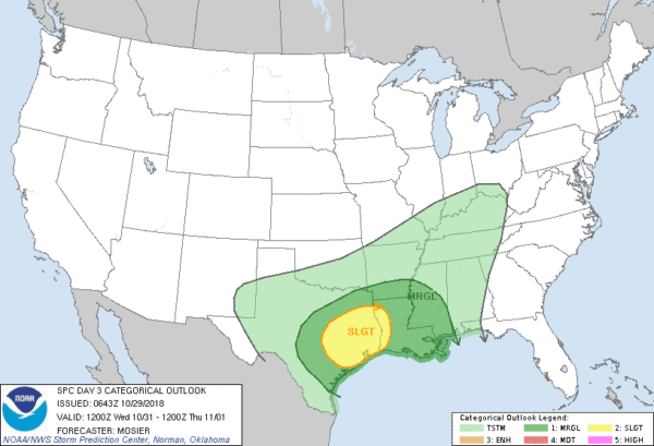
We will have much better clarity on this system within 48 hours of the event… just something to watch for now. SPC has defined a risk of severe storms for areas west of Alabama on Wednesday.
FRIDAY AND THE WEEKEND: Friday will be cooler with a clearing sky; the high will be in the low to mid 60s. Then, we are forecasting a picture perfect fall weekend with sunny days and fair nights Saturday and Sunday. Highs will be in the 60s, and lows mostly in the 40s. Colder pockets will see a low in the 30s.
NEXT WEEK: For now a decent part of the week looks dry with seasonal temperatures… see the Weather Xtreme video for maps, graphics, and more details.
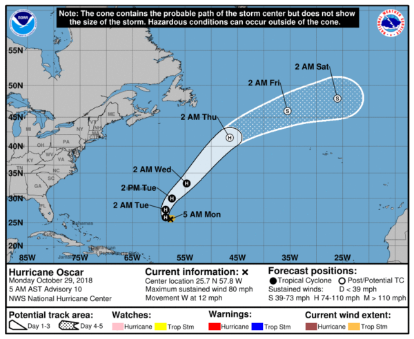
TROPICS: Hurricane Oscar in in the middle of the Atlantic with winds of 80 mph… it will move north, and then northeast this week and will remain far from land. The rest of the Atlantic basin is quiet.
BEACH FORECAST: Click here to see the AlabamaWx Beach Forecast Center page.
WEATHER BRAINS: Don’t forget you can listen to our weekly 90 minute show anytime on your favorite podcast app. This is the show all about weather featuring many familiar voices, including our meteorologists here at ABC 33/40.
CONNECT: You can find me on all of the major social networks…
Facebook
Twitter
Instagram
Pinterest
Snapchat: spannwx
I will be speaking to a senior adult group this morning at Vincent United Methodist Church… look for the next Weather Xtreme video here by 4:00 this afternoon. Enjoy the day!
Category: Alabama's Weather, ALL POSTS, Weather Xtreme Videos
About the Author (Author Profile)
James Spann is one of the most recognized and trusted television meteorologists in the industry. He holds the AMS CCM designation and television seals from the AMS and NWA. He is a past winner of the Broadcast Meteorologist of the Year from both professional organizations.Subscribe
If you enjoyed this article, subscribe to receive more just like it.


