

Cool Friday; Severe Storms Likely Early Next Week
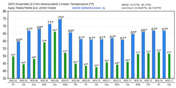
COOL, MOSTLY DRY: Clouds linger across Alabama in the wake of a cold front that passed through the state last night; temperatures are in the upper 40s and low to mid 50s, and those numbers won’t change much all day with a cool north breeze. Clearing will begin this afternoon, and tonight will be clear but chilly. We project lows early tomorrow in the 38-42 degree range for most North/Central Alabama communities… colder pockets could see some light frost.
THE WEEKEND: Very nice fall weather is the story; look for a sunny sky tomorrow and Sunday with a warming trend. We rise into the upper 60s tomorrow, and low 70s Sunday. A few spotty showers could reach West Alabama late Sunday night.
FOOTBALL WEATHER: Great weather for the high school games across the state tonight; look for a clear sky with temperatures falling from the low 50s at kickoff, into the 40s by the second half.
Auburn will host Texas A&M tomorrow (11:00a CT kickoff) at Jordan-Hare Stadium… the sky will be sunny with temperatures rising from near 64 degrees at kickoff, into the upper 60s by the second half.
Alabama is on the road to take on LSU in Baton Rouge tomorrow night (7:00p CT kickoff)… it will be a perfect night for football with a clear sky and temperatures falling through the 60s.
UAB will host UTSA at Legion Field in Birmingham tomorrow evening (6:30 CT kickoff)… the sky will be clear with low 60s at kickoff, and mid 50s by the fourth quarter.
POTENTIALLY DANGEROUS WEATHER EARLY NEXT WEEK: A deep, negative tilt upper trough will develop across the Central U.S. with very strong winds aloft, and a rapidly deepening surface low will move quickly from the Texas Panhandle to near Chicago. This will bring a rather potent severe weather setup to the southern U.S. Monday into Tuesday.
Based on the projected shear and instability values, it sure looks like thunderstorms across Alabama with this system will have the potential for large hail, damaging winds, and tornadoes. For now, the severe weather seems most likely late Monday night into Tuesday… generally in the range from midnight Monday night to noon Tuesday. SPC already has a risk of severe storms defined for most of Alabama during this time frame.
It is still early to be more specific, but with good model consistency, the pattern, and the time of the year, I would recommend everyone review your severe weather plan this weekend.
*Be sure you have multiple, reliable ways of receiving severe weather warnings. Have a NOAA Weather Radio in your home (if you already have one, change the batteries this weekend when you “fall back” and set the clocks tomorrow night). And, have a good app on your phone designed for warnings, like this one. NEVER rely on a siren.
*Know where you are going. In a site built home, that is a small room, on the lowest floor, away from windows, and near the center of the house. If you live in a mobile home, know the locations of nearby shelters and have a quick way of getting there.
*In your safe place, have a readiness kit that includes helmets for everyone (bicycle or batting helmets are great), portable airhorns, and hard soled shoes.
*Like April 27, 2011? That is not a good question; days like that are generational, and tend to happen every 40 years or so. All you need to know is that it takes just one tornado in the entire state, and if that tornado comes down your street, then it is YOUR April 27. We have to be ready for every severe weather threat.
REST OF NEXT WEEK: The weather will be cool and dry Wednesday through Friday with highs in the 60s and lows in the 40s… see the Weather Xtreme video for maps, graphics, and more details.
TROPICS: The Atlantic basin is quiet; tropical storm formation is not expected through next week.
BEACH FORECAST: Click here to see the AlabamaWx Beach Forecast Center page.
WEATHER BRAINS: Don’t forget you can listen to our weekly 90 minute show anytime on your favorite podcast app. This is the show all about weather featuring many familiar voices, including our meteorologists here at ABC 33/40.
CONNECT: You can find me on all of the major social networks…
Facebook
Twitter
Instagram
Pinterest
Snapchat: spannwx
I have a weather program this morning at Opelika Middle School… look for the next Weather Xtreme video here by 4:00 this afternoon. Enjoy the day!
Category: Alabama's Weather, ALL POSTS, Weather Xtreme Videos
About the Author (Author Profile)
James Spann is one of the most recognized and trusted television meteorologists in the industry. He holds the AMS CCM designation and television seals from the AMS and NWA. He is a past winner of the Broadcast Meteorologist of the Year from both professional organizations.Subscribe
If you enjoyed this article, subscribe to receive more just like it.


