


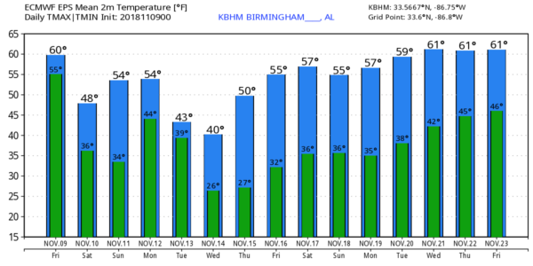
WET START: Rain is fairly widespread across Alabama early this morning ahead of a cold front about to enter the northwest corner of the state. Temperatures are between 55 and 60 degrees across the northern and central counties of the state, and this will be pretty much the high of the day. The rain will end during the midday hours, northwesters winds will increase, and temperatures will fall into the 40s by mid to late afternoon.
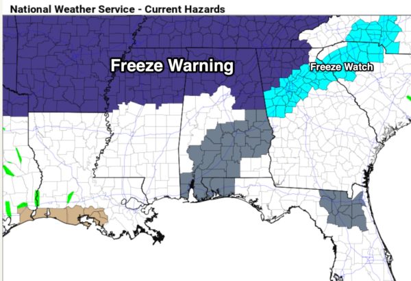
FREEZE WARNING: The sky will clear tonight, and we project lows in the 28-34 degree range for most places early tomorrow morning. A freeze warning is in effect for roughly the northern third of the state…
THE WEEKEND: Tomorrow will be sunny but cold for mid-November with a high between 47 and 50 degrees. Sunday morning will feature a low between 26 an 32 for most North/Central Alabama communities with freezing temperatures extending deeper into the state along with a widespread frost. Clouds will increase during the day Sunday with a high between 55 and 60 degrees.
FOOTBALL WEATHER: For the high school games tonight, we expect a clearing sky with temperatures falling through the 40s.
Tomorrow, Alabama hosts Mississippi State Saturday afternoon at Bryant-Denny Stadium (2:30p CT kickoff)… the sky will be sunny a kickoff temperatures near 50 degrees… then falling into the 40s by the fourth quarter.
Auburn is at Georgia tomorrow (6:00p CT kickoff)… the sky will be clear with temperatures falling from near 47 at kickoff, to near 40 by the final whistle.
UAB will host Southern Miss at Legion Field tomorrow evening (6:30p CT kickoff)… the sky will be clear with temperatures falling through the 40s, possibly reaching the 30s by the end of the game.
NEXT WEEK: A low moving through the northern Gulf of Mexico will bring widespread rain to the state Monday… it will be a cold rain with temperatures in the 40s all day. The rain will end Tuesday morning, but the day Tuesday will be cloudy, windy, cold, and raw with a high only in the low 40s. A north wind of 12-25 mph will make it feel colder. The sky will clear Tuesday night, and we drop into the mid 20s by daybreak Wednesday, with potential for a freeze deep into South Alabama.
The rest of the week will be dry with a slow warming trend… see the Weather Xtreme video for maps, graphics, and more details.
ON THIS DATE IN 2002: An EF-2 tornado moved from near Osceola, Arkansas to Covington, TN, and was the beginning of a multiple day severe weather event for “Dixie Alley”. On the following day, November 10, 2002, nine tornadoes touched down in Alabama killing 12 people and injuring many more. Some of the more signifiant damage was at Carbon Hill, in Walker County from an EF-3 tornado.
BEACH FORECAST: Click here to see the AlabamaWx Beach Forecast Center page.
WEATHER BRAINS: Don’t forget you can listen to our weekly 90 minute show anytime on your favorite podcast app. This is the show all about weather featuring many familiar voices, including our meteorologists here at ABC 33/40.
CONNECT: You can find me on all of the major social networks…
Facebook
Twitter
Instagram
Pinterest
Snapchat: spannwx
I have a weather program this morning at Tuggle Elementary in Birmingham… look for the next Weather Xtreme video here by 4:00 this afternoon. Enjoy the day!


