


HERE COMES THE COLD AIR: As forecast, temperatures have been falling across much of North Alabama this afternoon in the wake of a cold front that passed through earlier today; rain continues south and east of the front. The rain will continue to end over the next few hours, and the sky will clear from the northwest. By daybreak tomorrow, much of North Alabama will be at or below 32 degrees, and a freeze warning remains in effect…
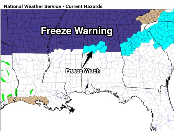
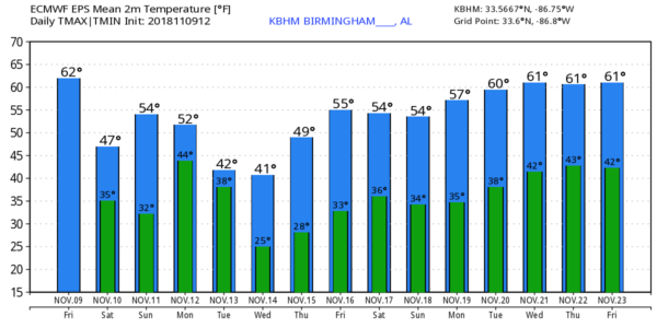
THE ALABAMA WEEKEND: Tomorrow will be a sunny, but cold and breezy day with a high between 45 and 50 degrees. We note the average high for November 10 at Birmingham is 66. Sunday morning will feature another freeze with lows in the upper 20s and low 30s for most places; the freeze will extend deeper into the central counties of the state. And, frost should be widespread with a clear sky and light wind. The day Sunday will be dry, but clouds will increase with a high in the mid to upper 50s. Some rain could reach the state after midnight Sunday night.
FOOTBALL WEATHER: For the high school games tonight, we expect a clearing sky with temperatures falling from the 40s into the upper 30s by the fourth quarter of the games.
Tomorrow, Alabama hosts Mississippi State Saturday afternoon at Bryant-Denny Stadium (2:30p CT kickoff)… the sky will be sunny a kickoff temperatures near 50 degrees… then falling into the 40s by the fourth quarter.
Auburn is at Georgia tomorrow (6:00p CT kickoff)… the sky will be clear with temperatures falling from near 47 at kickoff, to near 40 by the final whistle.
UAB will host Southern Miss at Legion Field tomorrow evening (6:30p CT kickoff)… the sky will be clear with temperatures falling through the 40s, possibly reaching the 30s by the end of the game.
NEXT WEEK: Monday will be cold and wet with rain much of the day; temperatures will have a very hard time getting out of the 40s. Then, on Tuesday, the rain ends early in the day, otherwise it will be windy and much cold with a high only in the low 40s… a north wind of 12-25 mph will make it feel colder. The sky will clear Tuesday night, and by daybreak Wednesday we expect a low in the mid 20s, very close to record levels. The record low at Birmingham on November 14 is 24, set in 1986.
Thursday morning will be cold as well with a clear sky and a low in the 20s for most places… then a slow warming trend begins Thursday afternoon. The latter half of the week will be dry… see the Weather Xtreme video for maps, graphics, and more details.
ON THIS DATE IN 2002: An EF-2 tornado moved from near Osceola, Arkansas to Covington, TN, and was the beginning of a multiple day severe weather event for “Dixie Alley”. On the following day, November 10, 2002, nine tornadoes touched down in Alabama killing 12 people and injuring many more. Some of the more signifiant damage was at Carbon Hill, in Walker County from an EF-3 tornado.
BEACH FORECAST: Click here to see the AlabamaWx Beach Forecast Center page.
WEATHER BRAINS: Don’t forget you can listen to our weekly 90 minute show anytime on your favorite podcast app. This is the show all about weather featuring many familiar voices, including our meteorologists here at ABC 33/40.
CONNECT: You can find me on all of the major social networks…
Facebook
Twitter
Instagram
Pinterest
Snapchat: spannwx
I had a great time today visiting with the first graders at Tuggle Elementary in Birmingham… be looking for them on the Pepsi KIDCAM today at 5:00 on ABC 33/40 News! My next Weather Xtreme video will be posted here Monday morning by 7:00… enjoy the weekend!


