

Cold, Wet Weather Through Thursday
COLD, DAMP, SOGGY: An upper trough is hanging back to the west of Alabama, and we remain in a broad southwest flow aloft with a moist airmass below. Cloudy and cold weather continues today with light rain/drizzle at times. A warm front is over the extreme southern part of the state, and we have some 60s near the Florida state line early this morning, but cold air will eventually push southward later today and tonight. For North/Central Alabama, most communities will hold in the 45-50 degree range all day.
TONIGHT/TOMORROW: No real change tonight… the weather will be cloudy and cold with a low around 40 degrees along with the chance of some scattered light rain and drizzle. Then, tomorrow, rain will increase again as the upper trough to the west lifts out. Rain should be fairly widespread tomorrow afternoon and tomorrow night, with additional rain amounts of around one inch likely.
To the west, a touch of freezing rain or sleet is possible over North Mississippi and West Tennessee tomorrow morning, where cold air is deeper, but no significant impact is expected there.
THURSDAY: Rain will end early in the day, otherwise this will be a cloudy and cold day with some drizzle possible. Parts of North Alabama won’t get out of the 30s… keep in mind our average high is in the mid 60s in mid-November. Some light wintry precipitation is possible over parts of Tennessee and Kentucky, but no major impact is expected there. The sky will finally clear Thursday night as dry air returns to the state.
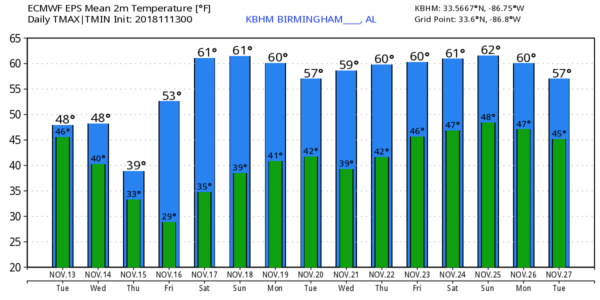
FRIDAY AND THE WEEKEND: The weather will be much brighter, with sunny cool days and clear cold nights. The high Friday will be in the mid 50s, followed by highs between 59 and 63 over the weekend. Coldest morning will come early Friday with most North/Central Alabama communities seeing a low between 28 and 32. South Alabama will be mostly in the mid to upper 30s early Friday morning.
THANKSGIVING WEEK: For now the weather looks cool and dry Monday through Wednesday with highs in the 55-60 degree range… the GFS then shows a surface low in the Gulf that will bring potential for rain on Thanksgiving Day Thursday. See the Weather Xtreme video for maps, graphics, and more details.
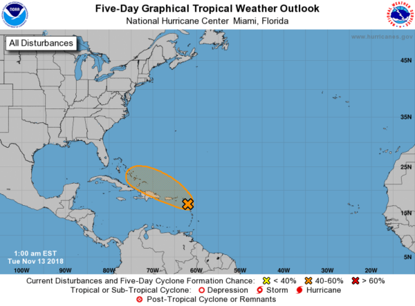
TROPICS: A disturbance near the Leeward Islands now has only a medium chance of development over the next five days; if anything does happen to form there it will be swept out into the open Atlantic late this week by the upper trough over the eastern third of the U.S. The rest of the Atlantic basin is quiet.
RAIN TOTALS: Here are some Monday rain totals from our team of Skywatchers…
Nances Creek 5.08″
Weaver 3.86″
Jemison 3.28″
Jacksonville 3.26″
Arley 3.23″
Moody 3.12″
Heflin 2.81″
Rainbow City 2.54″
Mountain Brook 2.53″
Bessemer 2.14″
Coker 2.12″
Concord 2.05″
Remlap 1.96″
Trussville 1.82″
Northport 1.73″
BEACH FORECAST: Click here to see the AlabamaWx Beach Forecast Center page.
WEATHER BRAINS: Don’t forget you can listen to our weekly 90 minute show anytime on your favorite podcast app. This is the show all about weather featuring many familiar voices, including our meteorologists here at ABC 33/40.
CONNECT: You can find me on all of the major social networks…
Facebook
Twitter
Instagram
Pinterest
Snapchat: spannwx
I have a weather program for the HeadStart program in Pickens County this morning in Carrollton… look for the next Weather Xtreme video here by 4:00 this afternoon. Enjoy the day!
Category: Alabama's Weather, ALL POSTS, Weather Xtreme Videos
About the Author (Author Profile)
James Spann is one of the most recognized and trusted television meteorologists in the industry. He holds the AMS CCM designation and television seals from the AMS and NWA. He is a past winner of the Broadcast Meteorologist of the Year from both professional organizations.Subscribe
If you enjoyed this article, subscribe to receive more just like it.


